Laser scanner - メーカー・企業93社の製品一覧とランキング | イプロス

更新日: 集計期間:Feb 18, 2026~Mar 17, 2026
※当サイトの各ページの閲覧回数を元に算出したランキングです。

Laser scannerのメーカー・企業ランキング

更新日: 集計期間:Feb 18, 2026~Mar 17, 2026
※当サイトの各ページの閲覧回数を元に算出したランキングです。

  1. null/null
  2. 横浜測器 本社 Kanagawa//Trading company/Wholesale
  3. あれとこれ Saitama//Service Industry
  4. 4 大浦工測 [東京本社・横浜支店・九州支店・関西支店・仙台営業所・ベトナム国ホーチミン事務所] Tokyo//General contractors and subcontractors
  5. 5 きんそく 本社・和歌山支店・名古屋営業所・北陸営業所・東京営業所・大阪営業所 Kyoto//Construction Consultant

Laser scannerの製品ランキング

更新日: 集計期間:Feb 18, 2026~Mar 17, 2026
※当サイトの各ページの閲覧回数を元に算出したランキングです。

  1. Restore drawings with 3D scanning too! First-time service campaign ongoing! あれとこれ
  2. 3D laser scanner 'BLK360 G2' acquires data in 20 seconds!
  3. High-speed, high-precision 3D laser scanner 'Leica RTC360'
  4. 4 Mobile handheld laser scanner "Leica BLK2GO"
  5. 5 How to Smartly Purchase Surveying Equipment Using Subsidies? 横浜測器 本社

Laser scannerの製品一覧

241~270 件を表示 / 全 292 件

表示件数

Utilizing a 3D laser scanner for on-site surveys of renovation work and current documentation!

By utilizing 3D laser scanners and point clouds for on-site surveys and current condition mapping, we can solve the labor shortage problem and achieve shorter construction periods and cost reductions!

【Project Methodology and Procedures】 1. 3D measurement using a 3D laser scanner 2. Synthesis and verification of the acquired point cloud 3. Noise removal of floating objects and moving objects within the point cloud 4. Creation of as-built data 5. Modeling from the point cloud to create 3D drawings 【Deliverables】 ■ As-built data (point cloud and 360° panoramic photos) ■ Drawing data modeled from the point cloud (compatible with 3D CAD/BIM) 【Details of Deliverables】 ■ As-built data (point cloud) - A collection of points with X, Y, Z coordinates and RGB coordinates obtained from the camera - Allows 3D display on a computer, enabling viewpoint changes and cross-section creation for viewing, with high-precision dimension measurement possible ■ As-built data (360° panoramic photos) - 360° panoramic photos taken from the position where the laser scanner was installed - Can be referenced overlaid on the point cloud, allowing for dimension measurement on the photos ■ 3D CAD drawings - CAD drawings that accurately reflect the current state of the building's structure, finishes, and equipment - High-precision piping modeling using automated piping modeling software - Created as BIM-compatible CAD data (using Revit, Rebro, Tfas, AutoCAD, Navisworks, etc.)

  • Drawing, tracing, CAD
  • Architectural design office
  • CG Perspective
  • Laser scanner

ブックマークに追加いたしました

ブックマーク一覧

ブックマークを削除いたしました

ブックマーク一覧

これ以上ブックマークできません

会員登録すると、ブックマークできる件数が増えて、ラベルをつけて整理することもできます

無料会員登録

We support i-Construction with the latest technology!

Full support for 【i-Construction】 with a community-based approach!

Leave your i-Construction needs to Kusano Measuring Instruments! We have numerous achievements within Fukushima Prefecture and will contribute to solving your challenges from consideration of implementation to support! ■ 3D Measurement Services... We support everything from 3D data design to creation using UAVs and 3D laser scanners. ■ ICT Construction for Heavy Machinery... We offer proposals for the introduction of bulldozer MC (Machine Control) and hydraulic excavator MG (Machine Guidance), among others. *For more details, please download the PDF or contact us.

  • Bulldozers and scrapers
  • Motor graders, roadbed machines, compaction machines
  • Laser scanner

ブックマークに追加いたしました

ブックマーク一覧

ブックマークを削除いたしました

ブックマーク一覧

これ以上ブックマークできません

会員登録すると、ブックマークできる件数が増えて、ラベルをつけて整理することもできます

無料会員登録

Laser Scanner J LZR-J

A compact laser sensor that detects three-dimensional objects with a 4-column laser curtain can be easily adjusted and set up using a dedicated remote control.

■Wide Detection Area The maximum detection distance is 9.9m x 9.9m. Distances can be specified in 10cm increments both vertically and horizontally. ■Three-Dimensional Detection Area (4-Column Laser Curtain) It has a curtain-like detection area with 4 columns (C1 to C4), enhancing detection capability. Depending on the installation location, you can choose to detect with 3 columns, 2 columns, etc., as desired. ■Automatic Setup Function It recognizes objects (such as floors, walls, structures, etc.) within the detection area and can limit the detection area to only the space visible from the sensor. You can set a non-detection zone between 5cm and 25cm in 5cm increments from the object, reducing false triggers. ■Supports Horizontal and Vertical Installation It can be installed horizontally or vertically, and can be mounted at angles of -45°, 0°, or 45° on either the right or left side. It is suitable for vertical detection at openings or walls, as well as horizontal detection near the floor or ceiling. ■Easy Setup with Remote Control The settings for this device are made using an adjustment remote control (RC-240). The settings can be confirmed through remote control operations and the indicator light on the sensor body.

  • Entrance/exit management and personal identification system
  • Laser scanner

ブックマークに追加いたしました

ブックマーク一覧

ブックマークを削除いたしました

ブックマーク一覧

これ以上ブックマークできません

会員登録すると、ブックマークできる件数が増えて、ラベルをつけて整理することもできます

無料会員登録

UAV 3D (three-dimensional) laser measurement (ICT) service

Please leave the 3D i-con construction support services to us.

Our ICT team conducts i-con construction support services using 3D technology, ranging from measurement to the creation of design data for ICT-equipped construction machinery and shape measurement. We offer services such as "UAV-mounted green laser measurement," which uses a laser scanner (green light) mounted on a UAV to measure underwater surfaces that cannot be captured by laser scanners (red light) or photographs, and "ground-based laser scanners," which can safely and quickly 3D model extensive terrains that include water. 【Service Details】 ■ UAV-mounted green laser measurement ■ Ground-based laser scanner (3D measurement) ■ UAV surveying (photogrammetry) *For more details, please download the PDF or feel free to contact us. SGS Co., Ltd. 8-1 Higashiyama-cho, Yonago City, Tottori Prefecture (0859) 32-3308

ブックマークに追加いたしました

ブックマーク一覧

ブックマークを削除いたしました

ブックマーク一覧

これ以上ブックマークできません

会員登録すると、ブックマークできる件数が増えて、ラベルをつけて整理することもできます

無料会員登録

[Laser Scanner and Point Cloud Utilization Case] Shoot Renovation Work

From drawing creation to sheet metal unfolding! It can be used in the process of measuring complex shapes on-site.

We utilized "laser scanners and point clouds" for the shoot modification work. We can handle everything from creating drawings to developing sheet metal layouts. By measuring from both ground and aerial perspectives, we can achieve seamless measurements. This can be used as an alternative to measuring tools like tape measures, and for measuring complex shapes on-site, so please feel free to contact us when needed. 【Features】 ■ Seamless measurements by measuring from both ground and aerial perspectives ■ Can measure anywhere, including high installations, hazardous areas, and dark places ■ Backpack type ■ Time-saving and cost-reducing ■ Easily grasp the overall picture at about 1/4 the cost of fixed scanners *For more details, please refer to the PDF materials or feel free to contact us.

  • Distance measuring device/length measuring device
  • Laser scanner

ブックマークに追加いたしました

ブックマーク一覧

ブックマークを削除いたしました

ブックマーク一覧

これ以上ブックマークできません

会員登録すると、ブックマークできる件数が増えて、ラベルをつけて整理することもできます

無料会員登録

3D laser scanner surveying services

Quickly acquire point cloud data that meets the required accuracy using suitable equipment according to the situation!

Our company offers surveying services using a "3D laser scanner" that can acquire 3D data of terrain and structures without contact. "3D laser scanner surveying" differs from traditional point-based surveying by rapidly and accurately capturing millions of point data per second, allowing for surface measurements of the target object. Additionally, the measurement data can be utilized as foundational data for various purposes, such as creating plans and cross-sectional diagrams, 3D modeling, and providing materials for the consideration of new construction, renovations, and maintenance of various facilities. 【Advantages】 ■ High safety ■ Visually easy to understand *For more details, please contact us.

  • Surveying
  • Structural Survey
  • Other analytical equipment
  • Laser scanner

ブックマークに追加いたしました

ブックマーク一覧

ブックマークを削除いたしました

ブックマーク一覧

これ以上ブックマークできません

会員登録すると、ブックマークできる件数が増えて、ラベルをつけて整理することもできます

無料会員登録

3D Laser Scanner 【Trimble SX12】

New genre of surveying equipment for measurement and civil engineering/i-Construction: scanning total station.

The Trimble SX12 has successfully expanded its role in public surveying by integrating a total station with a terrestrial laser scanner, significantly broadening the use of point clouds. Additionally, by adding new features, it enhances convenience and is expected to expand the scope of work for scanning total stations. The Trimble SX12 demonstrates its power in various fields such as civil engineering, construction, and surveying. The Trimble SX12 is a new genre of surveying instrument. It perfectly combines a high-precision, high-performance servo total station with a long-range 3D laser scanner and a high-resolution imager. With this single device, not only will your work efficiency increase, but it will also expand the possibilities of your surveying operations infinitely.

  • Other measuring instruments
  • others
  • Laser scanner

ブックマークに追加いたしました

ブックマーク一覧

ブックマークを削除いたしました

ブックマーク一覧

これ以上ブックマークできません

会員登録すると、ブックマークできる件数が増えて、ラベルをつけて整理することもできます

無料会員登録

Point cloud processing software [Elizion Infipoints]

Measure the current situation with a 3D laser scanner and create a CAD model with Infipoints!

InfiPoints is point cloud data utilization software that merges the real conditions of the field with virtual spaces on a computer. It offers stress-free operability even with billions of points and tens of gigabytes of point cloud data measured by 3D scanners. InfiPoints automatically extracts cylinders and planes from point clouds, enabling modeling of pipes, ducts, and steel materials. It also features the ability to automatically extract shapes such as planes and cylinders from point cloud data measured by mobile 3D laser scanners, including MMS, push-type, handheld, and backpack types, and is compatible with point cloud data created from images captured by drones using SfM (Structure from Motion) technology.

  • others
  • Laser scanner

ブックマークに追加いたしました

ブックマーク一覧

ブックマークを削除いたしました

ブックマーク一覧

これ以上ブックマークできません

会員登録すると、ブックマークできる件数が増えて、ラベルをつけて整理することもできます

無料会員登録

[Discontinued] 3D Laser Scanner Trimble TX8/TX6

[Discontinued] i-Construction, surveying, construction, building equipment, structural measurement, plant. 3D laser scanners providing the highest quality in the world.

[Discontinued] The Trimble TX8 is a laser scanner capable of managing the shapes of facilities and equipment that require high-density measurements, as well as understanding the current state of plants and factory equipment. It can be used in various applications such as as-built measurements, current surveys, and structural measurements. With the latest distance measurement technology, Trimble Lightning Technology, it offers ultra-fast scanning at a rate of up to 1 million points per second, a wide measurement range of up to 340 meters, and a very high precision with point cloud distance noise of just 2mm. It is a laser scanner that combines "speed," "density," and "accuracy."

  • others
  • Laser scanner

ブックマークに追加いたしました

ブックマーク一覧

ブックマークを削除いたしました

ブックマーク一覧

これ以上ブックマークできません

会員登録すると、ブックマークできる件数が増えて、ラベルをつけて整理することもできます

無料会員登録

3D Laser Scanner Trimble X9 FieldLink

A next-generation 3D laser scanner that breaks common sense for architecture, equipment, and BIM.

The Trimble X9 (for construction and facilities) is a site-completion type 3D laser scanner that quickly captures point clouds at construction sites for structures and facilities, allowing for consistency checks with data created in BIM. ■ Its lightweight and compact design, along with a lightweight and robust carbon tripod, makes it easy to take to the site. ■ Setting up for point cloud measurement is simple, enabling even beginners to easily capture and synthesize point clouds on-site. The synthesized point cloud data can be compared with various 2D/3D design data on a dedicated controller, allowing for on-site completion of progress management and quality verification. ■ When bringing it to the site for observation, it can measure point clouds according to pre-prepared design data, and even from a blank state, point clouds can be synthesized simply by observing from multiple arbitrary points, with data output available on-site. We offer various automated features to ensure that even those without specialized surveying knowledge can obtain high-quality point cloud data.

  • others
  • Laser scanner

ブックマークに追加いたしました

ブックマーク一覧

ブックマークを削除いたしました

ブックマーク一覧

これ以上ブックマークできません

会員登録すると、ブックマークできる件数が増えて、ラベルをつけて整理することもできます

無料会員登録

Spatial measurement business that conducts everything from point cloud data measurement to data processing.

From building exteriors and interiors to civil engineering, from acquiring to processing 3D data!

We would like to introduce our "Spatial Measurement Business." For point cloud data measurement, we use ground-based 3D laser scanners. We can accommodate measurements throughout Japan and can capture 3D data in a short time. You can request services from any process, and it is also possible to request just one specific process. 【List of Services】 ■ Point Cloud Data Measurement ■ Data Synthesis ■ Noise Processing ■ Data Classification ■ 3D Modeling *For more details, please refer to the PDF document or feel free to contact us.

  • Other construction services
  • Laser scanner

ブックマークに追加いたしました

ブックマーク一覧

ブックマークを削除いたしました

ブックマーク一覧

これ以上ブックマークできません

会員登録すると、ブックマークできる件数が増えて、ラベルをつけて整理することもできます

無料会員登録

Laser Data Trace Software "BSTrace"

Software that performs various processes without filtering laser data!

"BSTrace" is a laser data tracing software that allows for tasks such as "tracing work," "longitudinal and cross-sectional work," and "analysis of frame data." It is possible to recognize the outline of a building through slice cross-section processing. Linear data can be registered, and after calculating measurement points including plus stakes, longitudinal and cross-sectional data can be recognized. Additionally, while it is not fully automatic, it has a simple filtering function. 【Features】 ■ Basically displays in three screens: "2D display," "3D display," and "cross-section display" ■ Allows for location identification while checking wires connected to utility poles ■ Capable of creating longitudinal and cross-sectional diagrams ■ Can analyze frame data ■ Recognized CAD data is saved as 3D CAD data *For more details, please refer to the PDF materials or feel free to contact us.

ブックマークに追加いたしました

ブックマーク一覧

ブックマークを削除いたしました

ブックマーク一覧

これ以上ブックマークできません

会員登録すると、ブックマークできる件数が増えて、ラベルをつけて整理することもできます

無料会員登録

Watershed Analysis System "D-Bas"

Automatic access to the Geospatial Information Authority of Japan tiles! Automatically create triangular mesh surfaces.

"D-Bas" is a watershed analysis system that can automatically create triangular mesh surfaces by reading mesh data from the Geospatial Information Authority of Japan. It can also generate contour lines and recognize specified locations. If you are in an environment that can connect to the internet, you can download tile data from the Geospatial Information Authority's website and display it on our software. If you do not have a connection, it is also possible to download it in advance. 【Features】 ■ Automatic generation of contour line data ■ Automatic access to Geospatial Information Authority tiles ■ Export to PDF (3D) ■ Export to CAD data ■ Confirmation of flow cross-sections ■ Display of arbitrary cross-sections *For more details, please refer to the PDF materials or feel free to contact us.

ブックマークに追加いたしました

ブックマーク一覧

ブックマークを削除いたしました

ブックマーク一覧

これ以上ブックマークできません

会員登録すると、ブックマークできる件数が増えて、ラベルをつけて整理することもできます

無料会員登録

3D Output Management System 'MSF Ticalc'

Supports heat maps for the thickness of structures! Can be exported to 3DPDF files.

"MSF Ticalc" is a 3D volume management system that measures and calculates before and after construction work. It supports not only height heat maps for surface formation but also heat maps for the thickness of structures. Additionally, using our PDF3D converter, you can export these results to a 3DPDF file. 【Supported Structures】 ■ Pier: Oval/Rectangular (can be either sloped or vertical walls) ■ Abutment: Rectangular (can be either sloped or vertical walls) ■ Sewer: Large diameter circular pipes/Box culverts *For more details, please refer to the PDF materials or feel free to contact us.

ブックマークに追加いたしました

ブックマーク一覧

ブックマークを削除いたしました

ブックマーク一覧

これ以上ブックマークできません

会員登録すると、ブックマークできる件数が増えて、ラベルをつけて整理することもできます

無料会員登録

Promotion Bureau Response: Subsurface Drainage System

Corresponding to rice fields, farmland, and grasslands! Capable of creating area reports, capability calculation reports, and quantity reports.

The "Promotion Bureau Response: Subsurface Drainage System" is a system equipped with various functions, including automatic installation in artificially sloped areas. When planning, it is possible to implement the steepest and gentlest slopes, as well as the minimum burial depth and maximum excavation depth, with slope setting methods available for each type. For connecting different types of pipes, you can choose whether to connect the inner diameter or outer diameter when the connecting channel is a VU pipe. (Typically, inner diameter connection is used.) 【Functions (partial)】 ■ Hydraulic calculation function (automatic setting of pipe diameter and slope) ■ Pipe diameter interruption function for long subsurface drains ■ Creation of longitudinal and plan views ■ Recognition function for longitudinal diagrams of outlet sections (connecting channels) ■ Support for area division diagrams *For more details, please refer to the PDF materials or feel free to contact us.

  • Architectural Design Software
  • Laser scanner

ブックマークに追加いたしました

ブックマーク一覧

ブックマークを削除いたしました

ブックマーク一覧

これ以上ブックマークできません

会員登録すると、ブックマークできる件数が増えて、ラベルをつけて整理することもできます

無料会員登録

3D Modeling of Factories - Layout Consideration on PC!

A factory that frequently changes its layout. By modeling it in 3D, you can check the optimal arrangement in advance.

This time, we will introduce the modeling of a factory that has been actually converted into 3D. It is a factory that frequently changes its layout. If you are feeling that "it interferes with the columns," "I want to improve production efficiency," or "I want to secure the optimal flow," creating a 3D model allows you to check the optimal arrangement in advance. Of course, all the modeling we do is done to scale. Please be sure to watch until the end. 【Table of Contents】 00:04 Case Study 00:28 Layout 00:44 Modeling from Measurement Data (Point Cloud) We provide detailed information about 3D on our website. *For more details, please refer to the PDF document or feel free to contact us.

  • Other measuring instruments
  • Laser scanner

ブックマークに追加いたしました

ブックマーク一覧

ブックマークを削除いたしました

ブックマーク一覧

これ以上ブックマークできません

会員登録すると、ブックマークできる件数が増えて、ラベルをつけて整理することもできます

無料会員登録

3D-ifying the interior! We compared it with actual photos.

Measurement, drawing creation, and modeling using a 3D laser scanner.

This time, I modeled an indoor space. This is one room from an actual location, and there is a scene in the video where it is compared to a photo taken in reality. Please be sure to watch until the end! *For more details, please refer to the PDF document or feel free to contact us.

  • Other measuring instruments
  • Laser scanner

ブックマークに追加いたしました

ブックマーク一覧

ブックマークを削除いたしました

ブックマーク一覧

これ以上ブックマークできません

会員登録すると、ブックマークできる件数が増えて、ラベルをつけて整理することもできます

無料会員登録

3D measurement (simulation)

Our company conducts measurements using a 3D laser scanner.

Our company conducts measurements using a 3D laser scanner. After measuring with the 3D scanner, we created a model and performed simulations. Please be sure to watch until the end! *For more details, please refer to the PDF document or feel free to contact us.

  • Other measuring instruments
  • Laser scanner

ブックマークに追加いたしました

ブックマーク一覧

ブックマークを削除いたしました

ブックマーク一覧

これ以上ブックマークできません

会員登録すると、ブックマークできる件数が増えて、ラベルをつけて整理することもできます

無料会員登録

3D laser scanner 'Leica RTC360'

Solving the challenges of laser scanners on-site: "heavy" and "takes time to observe."

The "Leica RTC360" is a high-precision 3D reality capture solution that excels in speed and mobility. It digitizes the surrounding environment into 3D data, providing fast, user-friendly, and high-precision portable hardware and software, thereby improving the efficiency and productivity of operations in both the field and the office. Additionally, using the CycloneFIELD360 software, which allows for automatic registration, on-site provides excellent accuracy data that can be verified immediately. 【Features】 ■ Speedy ■ Mobility ■ High precision ■ On-site pre-processing *For more details, please download the PDF or feel free to contact us.

ブックマークに追加いたしました

ブックマーク一覧

ブックマークを削除いたしました

ブックマーク一覧

これ以上ブックマークできません

会員登録すると、ブックマークできる件数が増えて、ラベルをつけて整理することもできます

無料会員登録

Restoring drawings with 3D scanning! A collection of case studies is available!

The distance error is ±1mm with high precision! It emits 2 million laser points per second! No drawings are needed! There are many cases of restoring drawings with a 3D scanner!

We are offering a free collection of case studies filled with examples of utilizing "3D laser scanners" in various settings such as factories with height and complex equipment and piping, civil engineering sites, fields, and cultural heritage sites! You can view numerous proposals for implementation sites. Our company provides high-value-added products such as digital twin creation, renovation planning, digital archiving, and differential analysis. The equipment emits 2 million laser points per second. It can capture the shape of equipment and facilities in a wide range of 50 meters, with 300 degrees in the vertical direction and 360 degrees in the horizontal direction, as three-dimensional coordinate data (digital data) all at once. We excel in handling 3D CAD data, and by modeling, we can create visually understandable data even for those who are unfamiliar with the current state of construction sites or have limited construction knowledge. 【Featured Examples】 ■ Factories ■ Civil Engineering and Fields ■ Cultural Heritage ■ Concert Halls ■ Narrow Sites *For more details, please download the PDF or feel free to contact us. *We listen carefully to each customer's concerns and requests through phone calls, emails, and meetings, providing careful proposals and prompt responses to deliver peace of mind and trust.

ブックマークに追加いたしました

ブックマーク一覧

ブックマークを削除いたしました

ブックマーク一覧

これ以上ブックマークできません

会員登録すると、ブックマークできる件数が増えて、ラベルをつけて整理することもできます

無料会員登録

3D scanning measurement service

The man-hours for data acquisition have been significantly reduced! Tasks such as working at heights are no longer necessary, improving safety on site.

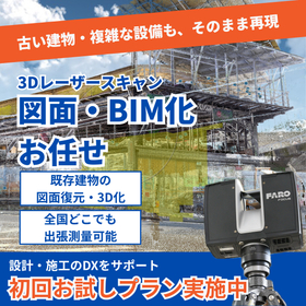
Our company offers a "3D Scanning Measurement Service" using 3D laser scanners to meet the diverse needs of our customers. We can obtain 3D data of building exteriors, complex structures, manufacturing lines, supply facilities, and large components, which are difficult to measure by hand, both indoors and outdoors. Unlike traditional surveying equipment that measures at "single points," our service features non-contact, rapid three-dimensional shape measurement. 【Benefits of Implementation (Partial)】 ■ Significantly reduces on-site work time ■ High safety ■ 3D data management of factories, plants, and equipment ■ Effective for considering factory line relocations, etc. ■ Interference checks *For more details, please download the PDF or feel free to contact us.

  • Surveying
  • Laser scanner

ブックマークに追加いたしました

ブックマーク一覧

ブックマークを削除いたしました

ブックマーク一覧

これ以上ブックマークできません

会員登録すると、ブックマークできる件数が増えて、ラベルをつけて整理することもできます

無料会員登録

Antibacterial body & high-performance laser scanner OPL-6845S

A barcode laser scanner with a wealth of implementation experience in a wide range of fields, including healthcare and distribution. It features a white and JIS-compliant antibacterial body, ensuring cleanliness and peace of mind at all times.

■ The latest model of the OPL-6845 series, which boasts long-selling success in the medical and distribution industries. ■ It features a white body made from JIS-compliant antibacterial and yellowing-resistant materials, ensuring it is always clean and safe to use. ■ Achieves high-speed reading from wide barcode touch scanning to distance reading. It also excels at reading barcodes printed on curved surfaces. ■ By pressing and holding the trigger button, you can switch between vibration mode and silent mode, allowing for reading confirmation without sounding a buzzer in medical settings. ■ By using a separately sold dedicated stand, you can read barcodes instantly with automatic detection without having to hold the barcode reader. ■ The data editing programming function allows for the output of certain parts of barcode data. It can also easily accommodate some outputs in formats like GS1 with simple settings.

  • Cash register peripherals and printers
  • Warehouse Management System (WMS)
  • Other store equipment and supplies
  • Laser scanner

ブックマークに追加いたしました

ブックマーク一覧

ブックマークを削除いたしました

ブックマーク一覧

これ以上ブックマークできません

会員登録すると、ブックマークできる件数が増えて、ラベルをつけて整理することもできます

無料会員登録

Be cautious of the weather when using the 3D scanner.

Support for the practical application of icon construction through rentals! Be mindful of the weather when using 3D scanners.

In some industries, I believe there are many situations where 3D scanners are utilized, but when using them, it is necessary to pay attention to the surrounding environment, especially the "weather." This is because the information obtained from a 3D scanner can be greatly affected by the weather. For example, measurements taken in areas with strong sunlight can be difficult because the light from the 3D scanner can be overwhelmed by the sunlight, making data collection challenging. During rainy weather, raindrops or snow can be scanned as point clouds, preventing data collection. When using a 3D scanner, by thoroughly understanding the weather conditions on the day of measurement and planning accordingly, smooth measurements can be achieved. 【Features】 ■ The information obtained from a 3D scanner can be greatly influenced by the weather. ■ Measurements in areas with strong sunlight can make data collection difficult. ■ Measurements during rainy weather can result in raindrops or snow being scanned as point clouds. ■ Similarly, measurements can also be difficult if it has just stopped raining or if the object is wet. *For more details, please refer to the PDF document or feel free to contact us.

  • Other measuring instruments
  • Laser scanner

ブックマークに追加いたしました

ブックマーク一覧

ブックマークを削除いたしました

ブックマーク一覧

これ以上ブックマークできません

会員登録すると、ブックマークできる件数が増えて、ラベルをつけて整理することもできます

無料会員登録

Presentation of materials! A document that explains the basics of 3D measurement and 3D scanners, along with practical examples.

Active in the manufacturing industry, such as creating maps within factories! Featuring the main types of 3D surveying and the industries that utilize them! We also introduce the basics of 3D surveying and practical examples.

We are offering a free document titled "Understanding 3D Measurement and 3D Scanners" from SGS Co., Ltd., which provides measurement services, data processing, rental, and sales using 3D laser scanners. The document includes detailed explanations with photos on topics such as "Main Types of 3D Measurement," "Industries Utilizing 3D Measurement," and "Concerns You May Have Consulted Us About." We encourage you to take a look. 【Contents (Excerpt)】 ■ Main Types of 3D Measurement ■ Industries Utilizing 3D Measurement ■ Be Cautious of Weather When Using 3D Scanners! ■ Why is Data from Laser Scanners Necessary to Process? ■ Outsourcing 3D Scanner Measurements is Recommended! *For more details, please refer to the PDF document or feel free to contact us.

  • Surveying
  • Laser scanner

ブックマークに追加いたしました

ブックマーク一覧

ブックマークを削除いたしました

ブックマーク一覧

これ以上ブックマークできません

会員登録すると、ブックマークできる件数が増えて、ラベルをつけて整理することもできます

無料会員登録