Laser scanner Product List and Ranking from 93 Manufacturers, Suppliers and Companies | IPROS

Last Updated: Aggregation Period:Feb 18, 2026~Mar 17, 2026
This ranking is based on the number of page views on our site.

Laser scanner Manufacturer, Suppliers and Company Rankings

Last Updated: Aggregation Period:Feb 18, 2026~Mar 17, 2026
This ranking is based on the number of page views on our site.

  1. null/null
  2. 横浜測器 本社 Kanagawa//Trading company/Wholesale
  3. あれとこれ Saitama//Service Industry
  4. 4 大浦工測 [東京本社・横浜支店・九州支店・関西支店・仙台営業所・ベトナム国ホーチミン事務所] Tokyo//General contractors and subcontractors
  5. 5 きんそく 本社・和歌山支店・名古屋営業所・北陸営業所・東京営業所・大阪営業所 Kyoto//Construction Consultant

Laser scanner Product ranking

Last Updated: Aggregation Period:Feb 18, 2026~Mar 17, 2026
This ranking is based on the number of page views on our site.

  1. Restore drawings with 3D scanning too! First-time service campaign ongoing! あれとこれ
  2. 3D laser scanner 'BLK360 G2' acquires data in 20 seconds!
  3. High-speed, high-precision 3D laser scanner 'Leica RTC360'
  4. 4 Mobile handheld laser scanner "Leica BLK2GO"
  5. 5 How to Smartly Purchase Surveying Equipment Using Subsidies? 横浜測器 本社

Laser scanner Product List

211~240 item / All 292 items

Displayed results

Leica Geosystems' 3D Laser Scanner 'BLK360'

Lightweight and compact for easy portability! High-speed scanning of up to 360,000 points per second with simple operation.

The BLK360 is a 3D laser scanner manufactured by Leica Geosystems that allows you to start scanning immediately by simply pressing a button on the device. Weighing just 1 kg, it is very lightweight and compact, making it easy to transport to job sites. With a scanning speed of up to 360,000 points per second, it can measure distances of up to 60 meters. The acquisition of HDR images, thermal images, and point cloud data, as well as streaming to an iPad Pro, is completed in just 3 minutes, significantly improving the efficiency of measurement tasks. For more details, please refer to the product catalog. 【Features】 - Lightweight, compact, and affordable 3D laser scanner - Easy operation with just a button press - Standard thermal camera included. Uses Class 1 invisible laser ★ We provide comprehensive support for the application process for manufacturing subsidies in collaboration with specialized consultants. Please feel free to contact us for more details. ★ Our company offers a variety of surveying instruments and systems, allowing us to make proposals tailored to your needs. For examples of products we handle, please refer to the basic information section.

  • Surveying
  • Other measuring instruments
  • Laser scanner

Added to bookmarks

Bookmarks list

Bookmark has been removed

Bookmarks list

You can't add any more bookmarks

By registering as a member, you can increase the number of bookmarks you can save and organize them with labels.

Free membership registration

Leica ScanStation P30/40

Introducing a 3D laser scanner that operates in harsh temperature environments from -20℃ to +50℃!

The "Leica ScanStation P30/40" is an ideal laser scanner that ensures accurate measurement time, measurement range, precision, and durability while reliably capturing details. It has a maximum measurement distance of 270 meters and generates high-quality 3D data and HDR images at a speed of 1 million points per second. With excellent measurement range and angular accuracy, as well as low range noise and two-axis compensation suitable for surveying, it produces high-quality, realistic 3D color point cloud data. 【Features】 ■ Reliable detail measurement ■ The right choice ■ High performance even in harsh environments ■ Reduced downtime ■ Total scanning system *For more details, please refer to the PDF document or feel free to contact us.

  • Other measuring instruments
  • Laser scanner

Added to bookmarks

Bookmarks list

Bookmark has been removed

Bookmarks list

You can't add any more bookmarks

By registering as a member, you can increase the number of bookmarks you can save and organize them with labels.

Free membership registration

[Subsidy-eligible product] Laser scanner Leica RTC360

Speedy, portable, and high precision! Equipped with seamless automatic data transfer functionality from the field to the office.

The "Leica RTC360 Laser Scanner" features a measurement speed of up to 2 million points per second and an advanced HDR imaging system, allowing for the acquisition of color 3D point cloud data in just 2 minutes. With its target-free automatic registration function powered by VIS technology and seamless automatic data transfer from the field to the office, it significantly reduces field measurement time and greatly enhances productivity. 【Features】 ■ Achieves 3D reality capture in a short time ■ Portable design and foldable dedicated tripod can be stored in a backpack ■ Can be carried anywhere ■ Simply go to the site and perform a quick and easy scan with a single button operation ★ This product qualifies as surveying equipment eligible for "subsidy utilization" upon purchase. It may be available for purchase at 1/2 to 1/3 of the regular price! If you are interested, please feel free to contact us. * For more details, please refer to the PDF materials or feel free to reach out to us.

  • Other measuring instruments
  • Laser scanner

Added to bookmarks

Bookmarks list

Bookmark has been removed

Bookmarks list

You can't add any more bookmarks

By registering as a member, you can increase the number of bookmarks you can save and organize them with labels.

Free membership registration

Introduction to the TLS (Terrestrial Laser Scanner) Product Lineup

Accessory options are also available! We offer products like the "RTC360," which can perform targetless point cloud synthesis.

We would like to introduce the 'TLS (Terrestrial Laser Scanner)' that we handle. Our lineup includes high-end models such as Leica's "Scan Station P Series" and PENTAX's "S-3180V," as well as the "RTC360," which allows for targetless point cloud synthesis, and the market's smallest and lightweight "BLK360." We also offer accessory options, so please use them according to your needs. 【Lineup】 ■Scan Station P Series ■RTC360 ■BLK360 ■Multi Station MS60 ■Z+F IMAGER5016 ■PENTAX S Series *For more details, please refer to the catalog or PDF materials, or feel free to contact us.

  • 2-2.png
  • 2-3.png
  • 2-4.png
  • 2-5.png
  • 25f5a4a954f507b021e194ccffec11ea.jpg
  • 3d_laser_scanner_02_822d8f8fca-300x362.jpg
  • Scanner
  • Other measuring instruments
  • Laser scanner

Added to bookmarks

Bookmarks list

Bookmark has been removed

Bookmarks list

You can't add any more bookmarks

By registering as a member, you can increase the number of bookmarks you can save and organize them with labels.

Free membership registration

Latest Case Studies of Point Clouds

Introducing point cloud data obtained from a laser scanner that measures various objects with excellent productivity, versatility, and operability!

Introducing point cloud data obtained from the latest laser scanner product lineup provided by Yokohama Measuring Instruments Co., Ltd.! The selection of the appropriate model is crucial depending on the intended use of the laser scanner. We offer the most suitable laser scanner for our customers from a wide range of models. The point cloud data acquired by leveraging the characteristics and features of each model has the potential to significantly impact our customers' future business development. 【Point Cloud Data by Characteristics】 ■ UAV Laser Scanner Point Cloud Data ■ Long-range Ground Laser Scanner Point Cloud Data ■ Mid-range Ground Laser Scanner Point Cloud Data ■ Compact and Lightweight Ground Laser Scanner Point Cloud Data *For more details, please refer to the catalog or PDF materials, or feel free to contact us.

  • 2.jpeg
  • 3.png
  • 4.png
  • 5.png
  • 6.png
  • Surveying
  • Other measuring instruments
  • Laser scanner

Added to bookmarks

Bookmarks list

Bookmark has been removed

Bookmarks list

You can't add any more bookmarks

By registering as a member, you can increase the number of bookmarks you can save and organize them with labels.

Free membership registration

Acquisition of realistic point cloud data is possible with Z+F IMAGER 5016.

[Subsidy-eligible products] Achieve 3D modeling at low cost with ultra-fast and ultra-high precision scanning! Providing new solutions that were previously difficult to realize!

The "PENTAX Z+F IMAGER 5016 Laser Scanner" achieves a compact and lightweight design while incorporating advanced HDR camera capabilities, built-in navigation system, and high-speed Wi-Fi functionality without compromising on the advantages of high precision, high scan rate, and low range noise provided by the phase difference method! It comes standard with an LED light for color photography in dark environments (capable of illuminating up to 10m). Equipped with high-speed Wi-Fi, it enables real-time high-speed data transfer of measurement data to a Tablet PC using the included IMAGER5016 dedicated software "LC SCOUT"! It allows for simultaneous verification of 3D point cloud data during measurement, significantly improving productivity. 【Features】 ■ Achieves 3D reality capture in a short time ■ Portable design that can be stored in a backpack *For more details, please refer to the PDF document or feel free to contact us. ★ This product is a surveying instrument eligible for "subsidy utilization" upon purchase. It may be available for purchase at 1/2 to 1/3 of the regular price! If you are interested, please do not hesitate to contact us.

  • Other measuring instruments
  • Laser scanner

Added to bookmarks

Bookmarks list

Bookmark has been removed

Bookmarks list

You can't add any more bookmarks

By registering as a member, you can increase the number of bookmarks you can save and organize them with labels.

Free membership registration

Providing surveying equipment for land, air, and sea. *3D data examples are currently being distributed.

Special introduction of surveying equipment compatible with land, air, and sea. We are currently offering some of the data obtained with the surveying equipment as materials!

Our company provides comprehensive support from the application for manufacturing subsidies and business restructuring subsidies to the introduction of surveying equipment. Many companies are utilizing subsidies to introduce surveying equipment and laser scanners, and this time we are presenting actual 3D data examples obtained from surveying equipment. [Overview of the Materials] *The relevant document is "Collection of Case Studies on Laser Scanners Introduced Using Subsidies." ■ Recent adoption status of Yokohama Measuring Instruments ■ Breakdown of adopted subsidies ■ Past subsidy introduction achievements and models ■ Actual 3D data examples obtained from surveying equipment [Adoption Rate Achievements (as of May 16, 2022)] ■ Manufacturing Subsidy: 97% (32 out of 33 companies adopted) ■ Business Restructuring Subsidy: 75% (6 out of 8 companies adopted) *Please view the materials from the "Download" link below. *We also conduct meetings and online meetings regarding subsidy application support, so please feel free to let us know if you wish to do so. *For any other inquiries, please do not hesitate to contact us.

  • イプロス用事業再構築補助金表紙?.jpg
  • イプロス用ものづくり補助金表紙?.jpg
  • Development permit application
  • Laser scanner

Added to bookmarks

Bookmarks list

Bookmark has been removed

Bookmarks list

You can't add any more bookmarks

By registering as a member, you can increase the number of bookmarks you can save and organize them with labels.

Free membership registration

HERON WEARABLE LASER SCANNER

Equipped with two laser scanners oriented horizontally and vertically, stable 360-degree point cloud data can be obtained just by walking!

【Subsidy-Eligible Product】The 'HERON PORTABLE 3D MAPPING SYSTEM (Backpack-type Laser Scanner)' is equipped with two laser scanners directed horizontally and vertically, allowing for the acquisition of 360-degree point cloud data simply by walking. It simultaneously captures Full HD video (1920×1080 pixels / 15fps) while scanning, and for areas requiring high-resolution images, it can stop to take 5K still images (5640×2820 pixels). The real-time 3D data is displayed on a tablet device, enabling measurements while confirming that data is being accurately captured, making it a backpack-type 3D laser scanner. 【Features】 ■ Lightweight ■ Time and cost-saving ■ Usable indoors and outdoors ■ Real-time 3D measurement ■ Easy setup ■ Capable of walking measurements ■ Easy tablet verification ■ Simple software processing *For more details, please refer to the PDF document or contact us directly. ★ This product is a surveying instrument eligible for "subsidy utilization" upon purchase. It may be available for purchase at 1/2 to 1/3 of the regular price! If you are interested, please feel free to contact us.

  • Other measuring instruments
  • Laser scanner

Added to bookmarks

Bookmarks list

Bookmark has been removed

Bookmarks list

You can't add any more bookmarks

By registering as a member, you can increase the number of bookmarks you can save and organize them with labels.

Free membership registration

Compact ground-based laser scanner 'Leica BLK360 G2'

Lightweight and compact for easy portability! High-speed scanning of up to 680,000 points per second with simple operation.

The "BLK360 G2" can perform a full scan, including spherical images, in just 20 seconds, which is more than five times faster than the conventional BLK360, with just the push of a button. The data from the BLK360 G2 is useful for a wide range of applications, from traditional architecture and construction to innovative VFX (visual effects) and VR (virtual reality). With a scanning speed of up to 680,000 points per second, it can measure up to 45 meters away. Additionally, the data from the BLK360 G2 is beneficial for many applications, from traditional architecture and construction to innovative VFX (visual effects) and VR (virtual reality). For more details, please refer to the product catalog. 【Features】 ■ Lightweight, compact, and affordable 3D laser scanner ■ Easy operation with just the push of a button ★ We provide comprehensive support for the application process for manufacturing subsidies in collaboration with specialized consultants. Please feel free to contact us for more details. ★ Our company offers a variety of surveying equipment and systems, and we can provide proposals tailored to your needs. Please refer to the basic information section for examples of our products.

  • Surveying
  • Other measuring instruments
  • Laser scanner

Added to bookmarks

Bookmarks list

Bookmark has been removed

Bookmarks list

You can't add any more bookmarks

By registering as a member, you can increase the number of bookmarks you can save and organize them with labels.

Free membership registration

TS measurement and scanner model TOPCON GTL-1200

Solve the challenges of 3D point cloud measurement with an on-site completion workflow!

【Features】 ■ Total station surveying and laser scanning measurements can be performed with one device ■ Point cloud density is twice that of conventional machines ■ Ideal for construction management using BIM ■ Effective for civil engineering, surveying, and maintenance management ■ Equipped with the onboard program MAGNET Field ■ Includes a Wi-Fi module ■ Remote operation via Collage Site is also possible *For more details, please refer to the PDF document or feel free to contact us.

  • Other civil engineering services
  • Surveying
  • Laser scanner

Added to bookmarks

Bookmarks list

Bookmark has been removed

Bookmarks list

You can't add any more bookmarks

By registering as a member, you can increase the number of bookmarks you can save and organize them with labels.

Free membership registration

Fully autonomous flying laser scanner "Leica BLK2FLY"

Orders will start in Japan from March 1, 2024! Fully autonomous flying laser scanner Leica BLK2FLY.

The "Leica BLK2FLY" can perform 3D scanning in hard-to-reach places such as ceilings and roofs, both indoors and outdoors. It captures the exterior of buildings, structures, and environments, creating 3D point clouds while in flight. It can be activated with just a few taps on a tablet, allowing for aerial scanning of structures and environments. Aerial scanning is beneficial for accurately capturing the features and dimensions of a structure's exterior, especially in cases where access is difficult or where it is hard to reach. 【Features】 ■ One-button operation ■ No calibration required for flight ■ Safe and stress-free flight enabled by obstacle detection features ■ Easy creation of automated flight plans from the operating application

  • Other civil engineering services
  • Surveying
  • Laser scanner

Added to bookmarks

Bookmarks list

Bookmark has been removed

Bookmarks list

You can't add any more bookmarks

By registering as a member, you can increase the number of bookmarks you can save and organize them with labels.

Free membership registration

Mobile Mapping SLAM Laser Scanner

A mobile measurement system equipped with the Z+F IMAGER5016 in a "backpack"!

A mobile measurement system with the Z+F IMAGER5016 attached to a backpack. - Just by wearing it and walking, you can measure the structure of surrounding buildings! - Equipped with a 360° camera to capture RGB color point cloud data. - The Z+F IMAGER5016 can be attached with a single touch.

  • Surveying Office
  • Laser scanner

Added to bookmarks

Bookmarks list

Bookmark has been removed

Bookmarks list

You can't add any more bookmarks

By registering as a member, you can increase the number of bookmarks you can save and organize them with labels.

Free membership registration

Subsidy application service

Recommended for surveyors, land and house investigators, and those in construction and civil engineering! Support is available nationwide.

Yokohama Measuring Instruments Co., Ltd. offers document preparation services for subsidy applications. We operate on a complete success fee basis, with an acceptance rate of over 85%. We provide support nationwide from the application for subsidies to the grant decision, order delivery, and receipt of subsidy funds. Are you considering introducing new equipment using subsidies? Please feel free to contact us for details and applications. 【Features】 ■ Complete success fee system ■ Acceptance rate of over 85% ■ Nationwide support available *For more details, please download the PDF or feel free to contact us.

  • ?補助金の申請サービス 画像2.png
  • ?補助金の申請サービス 画像3.png
  • ?補助金の申請サービス 画像4.png
  • ?補助金の申請サービス 画像5.png
  • ?補助金の申請サービス 画像6.png
  • Customer Support
  • Laser scanner

Added to bookmarks

Bookmarks list

Bookmark has been removed

Bookmarks list

You can't add any more bookmarks

By registering as a member, you can increase the number of bookmarks you can save and organize them with labels.

Free membership registration

High-Quality 3D Laser Scanner Z+F IMAGER Series

Incredible measurement accuracy and speed. Utilize subsidies to realize DX for point cloud data right now! Z+F IMAGER 5024 series.

The Z+F IMAGER 5024 series is a top-of-the-line phase-based ground-mounted 3D laser scanner developed by the German company Z+F. It maintains ultra-high precision at the millimeter level while achieving an overwhelming high-speed scan of up to 2.2 million points per second. Combined with a maximum measurement range of 365 meters, it enables efficient data acquisition even on large-scale sites. Its greatest feature is its robustness, thanks to a fanless completely sealed structure. Compliant with protection class IP54, it can be safely used in dusty construction sites and adverse weather conditions. Additionally, the built-in HDR camera and powerful LED lights allow for the generation of clear color point cloud data even in dark environments. Packed with practical features such as real-time data synthesis and verification functions on-site, as well as options for model upgrades later, it is the highest quality solution that meets the needs of professionals in architecture, civil engineering, plants, and cultural heritage. We encourage you to consider it as a strong partner for improving operational efficiency and promoting digital transformation by utilizing national subsidy programs.

  • Other measuring instruments
  • Laser scanner

Added to bookmarks

Bookmarks list

Bookmark has been removed

Bookmarks list

You can't add any more bookmarks

By registering as a member, you can increase the number of bookmarks you can save and organize them with labels.

Free membership registration

Information on "ICT Services"

Support for creating data for TS output management and surveying operations on-site.

Our company conducts surveying operations for ICY construction (i-Construction), such as 3D current condition surveys using laser scanners and photogrammetry using drones. We also support the creation of design data for machine control. We accept requests for construction surveying (setting up benchmarks, measuring construction positions), boundary surveying, GNSS surveying (GPS), and building surveys. Please feel free to consult us if you have any requests. 【Features】 ■ The cost for 3D current condition surveys and data creation is low due to direct orders from heavy machinery leasing companies. ■ Simultaneous establishment of reference points and control points makes it easier to ensure consistency with public coordinates and elevations. ■ We can respond quickly even if sudden surveying locations arise due to design changes. *For more details, please download the PDF or feel free to contact us.

  • Surveying Office
  • Surveying Consulting
  • photograph
  • Laser scanner

Added to bookmarks

Bookmarks list

Bookmark has been removed

Bookmarks list

You can't add any more bookmarks

By registering as a member, you can increase the number of bookmarks you can save and organize them with labels.

Free membership registration

Technical Introduction to Liquefaction Analysis Using Two-Dimensional Nonlinear Sequential Integration Method

By utilizing numerical analysis techniques, it is possible to make quantitative and objective judgments!

The 'Two-Dimensional Nonlinear Sequential Integration Method for Liquefaction Analysis' is a numerical analysis technique that allows for the reproduction of site conditions by creating an analysis model and setting parameters. This technique is used to predict the behavior of slopes that are likely to liquefy and collapse under Level 2 seismic motion, with the aim of considering appropriate countermeasure methods. [Technical Details] - Reproduces site conditions by creating an analysis model and setting parameters - Reproduces the stress spectrum and input seismic waveforms of the input seismic motion based on assumed seismic motion - Visually reproduces the response of the foundation and the analysis target - Visually reproduces areas of reduced safety factor due to liquefaction and sliding blocks *For more details, please download the PDF or feel free to contact us.

  • Site and ground investigation
  • Geological Survey
  • Environmental Survey
  • Laser scanner

Added to bookmarks

Bookmarks list

Bookmark has been removed

Bookmarks list

You can't add any more bookmarks

By registering as a member, you can increase the number of bookmarks you can save and organize them with labels.

Free membership registration

Information on "3D Laser Scanner Measurement"

3D laser scanner technology capable of high-speed, efficient, and highly accurate measurements over a wide range!

At NAO Planning Co., Ltd., all data is digital data, allowing us to significantly reduce the effort required for creating as-built data through our "3D Laser Scanning Measurement." Three-dimensional coordinates can be obtained safely and in a short time. This technology is utilized in various tasks such as cultural heritage measurement and disaster recovery. Additionally, we can perform extensive measurements that were not possible with traditional total stations, achieving high-speed, efficient, and high-precision results at 50,000 points per second with 360° x 270° full dome measurement. 【Features】 ■ Significantly reduces the effort required for creating as-built data since everything is digital data. ■ More cost-effective CG creation compared to traditional methods, enabling various applications. ■ Makes a significant contribution to the restoration and preservation planning of cultural heritage sites such as castles. *Please feel free to contact us for more details.

  • Surveying
  • Surveying Office
  • Laser scanner

Added to bookmarks

Bookmarks list

Bookmark has been removed

Bookmarks list

You can't add any more bookmarks

By registering as a member, you can increase the number of bookmarks you can save and organize them with labels.

Free membership registration

Introduction to the Surveying Business of Kindaigiken Co., Ltd.

We are conducting surveys using a ground laser scanner (3D Laser Scanner)!

Our company conducts general land surveying, crack investigations, general GNSS surveying, and three-dimensional measurements using ground laser scanners. For three-dimensional measurements, we have introduced the "3D Laser Scanner GLS-2000" for high-speed and high-precision multi-range scanning. Please feel free to contact us if you have any requests. 【Business Activities】 ■ General land surveying ■ General depth and shallow surveying ■ General GNSS surveying ■ Three-dimensional measurements using ground laser scanners ■ Crack investigations ■ Erosion control foundation surveys *For more details, please download the PDF or contact us.

  • Surveying Office
  • Surveying Consulting
  • Surveying
  • Laser scanner

Added to bookmarks

Bookmarks list

Bookmark has been removed

Bookmarks list

You can't add any more bookmarks

By registering as a member, you can increase the number of bookmarks you can save and organize them with labels.

Free membership registration

Laser scanner "ZEB-HORAIZON"

Introducing a three-dimensional laser mobile mapping system capable of creating floor plans and more.

The "ZEB-HORIZON" is a handheld laser scanner that enables three-dimensional mobile mapping without GPS location information using the SLAM method. The acquired mobile mapping data can be used not only for outputting three-dimensional point clouds but also for creating floor plans and other documents with dedicated software. By leveraging the advantages of the SLAM method and the handheld design, it can be utilized for creating three-dimensional data in fields such as indoor surveys, forest surveys, equipment inspections, and slope investigations. 【Features】 ■ Enables three-dimensional mobile mapping without GPS location information ■ Incorporates the benefits of the SLAM method and handheld design *For more details, please refer to the PDF document or feel free to contact us.

  • Other analytical equipment
  • Laser scanner

Added to bookmarks

Bookmarks list

Bookmark has been removed

Bookmarks list

You can't add any more bookmarks

By registering as a member, you can increase the number of bookmarks you can save and organize them with labels.

Free membership registration

In the retail industry! Laser scanner 'MS7120 Orbit(R)'

Reads symbols at a speed of 1,120 scans per second! Significantly improves on-site work efficiency! Omni-directional laser scanner suitable for the retail industry.

The "MS7120 Orbit" is an omnidirectional laser scanner that provides innovative and comfortable solutions for retail stores with limited counter space. This compact, lightweight, and sturdy product emits 20 lasers (patented) and has a very clear reading range center. Additionally, it reads symbols at a speed of 1,120 scans per second, significantly improving on-site work efficiency. 【Features】 ■ 20 omnidirectional lasers ■ Optimized reading ■ Adjustable scanner head angle ■ Flash ROM ■ Automatic reading *For more details, please download the PDF or feel free to contact us.

  • Other office supplies
  • Laser scanner

Added to bookmarks

Bookmarks list

Bookmark has been removed

Bookmarks list

You can't add any more bookmarks

By registering as a member, you can increase the number of bookmarks you can save and organize them with labels.

Free membership registration

Measurement system

New MR technology for surveying support! Significant reduction in time and costs!

With our surveying system, using scanners and GNSS, it is possible to grasp the current situation in about two weeks, instead of the usual one month. While viewing the created 3D model with MR (Mixed Reality) technology, we efficiently support the positioning of the current situation. Additionally, we offer this service at a low cost, which typically ranges from 5 to 10 million yen. 【Features】 ■ Reduces the number of construction projects and cuts construction and labor costs ■ Enables in-house surveying in a short period with an easy-to-use surveying system ■ Significantly reduces personnel, time, and costs with a surveying system that does not require outsourcing, etc. *For more details, please download the PDF or feel free to contact us.

  • Surveying Office
  • Surveying Consulting
  • Surveying
  • Laser scanner

Added to bookmarks

Bookmarks list

Bookmark has been removed

Bookmarks list

You can't add any more bookmarks

By registering as a member, you can increase the number of bookmarks you can save and organize them with labels.

Free membership registration

Az Build Modeling Services 3D Laser Scanner Measurement

No drawings! Unable to understand the current situation due to modifications! A 3D laser scanner to solve the design for factories, ruins, and ballast water treatment systems [Catalog available].

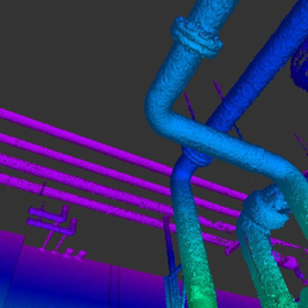
3D laser measurement is a pioneering technology for the upcoming era of 3D information. The data obtained using a 3D laser scanner, known as "point cloud," improves various operations for our customers. We propose low-cost, high-performance measurements tailored to your needs. Through point cloud synthesis and alignment, we provide high-quality point cloud data. Case Study: Plant When there are no 2D drawings or the current conditions are unclear due to modifications, creating drawings using 3D measurement data is effective. Modeling and drawing through 3D measurement significantly reduces the costs of repair work. *For more details, please download the catalog or feel free to contact us.

  • Surveying
  • Measurement and analysis equipment leasing and rental
  • Analysis and prediction system
  • Laser scanner

Added to bookmarks

Bookmarks list

Bookmark has been removed

Bookmarks list

You can't add any more bookmarks

By registering as a member, you can increase the number of bookmarks you can save and organize them with labels.

Free membership registration

[Case Study Collection] GS-1

Introducing a case study interview on the implementation of GS-1!

You can download the interview article with customers who have introduced GS-1. Case Study 1 【From point cloud acquisition to data processing shortened from 1 week to 1 day! Improvement in productivity】 ▶ Challenges before introduction All processes from point cloud acquisition to design data creation were outsourced, leading to high time and costs. ▶ Effects of introduction - The time from point cloud acquisition to data processing was shortened from about 1 week to about 1 day. - Awareness of point clouds increased within the company, promoting in-house production. Case Study 2 【Expanding possibilities! Aiming for further development of surveying technology】 ▶ Challenges before introduction - UAV laser had areas where the point cloud density was low, making it difficult to create current condition plans using only UAV laser. ▶ Effects of introduction - GS-1 was able to supplement areas that could not be measured by UAV laser. - Efficient measurement of detailed areas of vast sites was achieved by using GS-1 in conjunction. - The options for surveying methods expanded.

  • Surveying
  • Laser scanner

Added to bookmarks

Bookmarks list

Bookmark has been removed

Bookmarks list

You can't add any more bookmarks

By registering as a member, you can increase the number of bookmarks you can save and organize them with labels.

Free membership registration

CHCNAV RS10

A handheld 3D laser scanner that enables precise measurements in real-time, both indoors and outdoors.

The RS10 is a high-precision handheld laser scanner that combines RTK, laser, and visual fusion technologies. It enables high-precision surveying in various environments, both indoors and outdoors. 【Fusion of RTK and SLAM】 - Real-time SLAM calculations with 5cm accuracy - Post-processing SLAM calculations with relative accuracy within 1cm RTK positioning accuracy is within 3cm, serving as a benchmark for SLAM mapping, ensuring 5cm accuracy in all environmental scenarios. 【Efficient workflow with loop-free operation】 Real-time calibration and loop-free route planning using high-precision RTK positioning data. 【Adaptability to dynamic environments】 【Same coordinate system from outdoors to indoors】 【Vi-LiDAR technology】

  • Surveying
  • Laser scanner

Added to bookmarks

Bookmarks list

Bookmark has been removed

Bookmarks list

You can't add any more bookmarks

By registering as a member, you can increase the number of bookmarks you can save and organize them with labels.

Free membership registration

FLIGHTS SCAN 100

100 degrees 1 million points UAV-mounted laser scanner

The highly anticipated high-end model of the FLIGHTS SCAN series, the "FLIGHTS SCAN 100," has been introduced as a UAV-mounted laser scanner (LiDAR) featuring a single-line sensor with a 100-degree FOV and a maximum point cloud emission rate of 1 million points per second. It achieves even more efficient acquisition of high-density point clouds with reduced thickness compared to previous models. Additionally, by utilizing it as a total solution alongside software services, it greatly contributes to further efficiency and precision in operations. We invite you to experience the unique usability of the FLIGHTS SCAN series.

  • Surveying Office
  • Civil Engineering Design Office
  • Laser scanner

Added to bookmarks

Bookmarks list

Bookmark has been removed

Bookmarks list

You can't add any more bookmarks

By registering as a member, you can increase the number of bookmarks you can save and organize them with labels.

Free membership registration

Suitable for data acquisition in the maintenance management field for various subjects!

Safely and efficiently with a 3D laser scanner! 3D measurement of various locations!

The "Fixed 3D Laser Scanner" is a surveying instrument that can instantly acquire 3D coordinate (point cloud) data of objects such as terrain and structures using lasers, without touching the measurement target. Unlike traditional "single point" measurements, it enables 3D surveying in a "surface" manner through high-precision and continuous high-speed acquisition of point cloud data. It allows for safe, efficient, and effective work in measuring the volume of structures, measuring the displacement of tunnel cross-sections, and recording measurements at archaeological sites, disaster areas, and accident scenes. 【Features】 ■ Instantly acquires 3D coordinate (point cloud) data ■ Enables 3D surveying in a "surface" manner ■ Applicable in various fields ■ Allows for safe, efficient, and effective work ■ Data is in a simple XYZ text format *For more details, please refer to the PDF document or feel free to contact us.

  • Measurement and Inspection
  • Measurement and Analysis Equipment
  • Laser scanner

Added to bookmarks

Bookmarks list

Bookmark has been removed

Bookmarks list

You can't add any more bookmarks

By registering as a member, you can increase the number of bookmarks you can save and organize them with labels.

Free membership registration

[Reference Case] Layout Plan for Safety Measures within the Plant

A case where 3D laser scanning was focused on areas planned for safety fence installation, and point cloud data was obtained!

We would like to introduce a case where we focused on 3D laser scanning the planned locations for safety fences throughout the entire factory and obtained point cloud data. The client's request was to safely and accurately grasp the current situation on a desktop, supporting the decision-making of the client and facilitating information sharing with construction stakeholders. By utilizing the point cloud data measured this time, it has become possible to share intuitive images that cannot be conveyed through work instructions or construction plans for the replacement and installation simulation of safety fences. 【Benefits】 ■ Ability to understand the situation of a vast area ■ Accurately grasping interfering parts in advance, reducing installation issues and rework ■ Sharing images among construction stakeholders *For more details, please refer to the PDF document or feel free to contact us.

  • Measurement and analysis equipment leasing and rental
  • Laser scanner

Added to bookmarks

Bookmarks list

Bookmark has been removed

Bookmarks list

You can't add any more bookmarks

By registering as a member, you can increase the number of bookmarks you can save and organize them with labels.

Free membership registration

I want to know how it works! About 3D laser scanners.

An explanation of what a "3D laser scanner" is and what it can do!

We have briefly introduced it on our website and blog articles, but this time we will explain what a "3D laser scanner" is, what it can do, and details about its mechanism and accuracy. It may be content that seems obvious now, but we will delve a little deeper than before. *You can view the detailed content of the blog through the related links. For more information, please refer to the PDF materials or feel free to contact us.*

  • Scanner
  • Laser scanner

Added to bookmarks

Bookmarks list

Bookmark has been removed

Bookmarks list

You can't add any more bookmarks

By registering as a member, you can increase the number of bookmarks you can save and organize them with labels.

Free membership registration

Huh? Can't this be measured? "Weaknesses of 3D Laser Scanners"

A representative example of what laser scanners struggle with! Introducing a technology blog.

A 3D laser scanner obtains positional coordinates by emitting laser light and receiving the reflected laser light from objects, allowing for the measurement of three-dimensional shapes. One weakness of 3D laser scanners is related to the "reflected light" used to acquire data. Both "light" and "laser" can experience phenomena such as reflection and refraction. Even though it may seem high-tech, not everything can be measured as intended. Here, we will introduce some typical challenges that laser scanners face. *For more detailed information, please refer to the related links. For further details, please check the PDF materials or feel free to contact us.*

  • Measurement and analysis equipment leasing and rental
  • Laser scanner

Added to bookmarks

Bookmarks list

Bookmark has been removed

Bookmarks list

You can't add any more bookmarks

By registering as a member, you can increase the number of bookmarks you can save and organize them with labels.

Free membership registration

Area Imaging Scanner 'Xenon 1900h'

Color barcode reading! Made with medical-grade plastic that excels in chemical resistance.

The "Xenon 1900h" is a healthcare-oriented area imaging scanner that employs a color-compatible CMOS sensor. Thanks to Color Fusion technology, it is capable of capturing color images and reading color symbols such as red/orange/yellow, which were impossible with traditional monochrome scanners. We also offer a wireless model, the "Xenon 1902h," equipped with Bluetooth Class2 ver2.1. 【Features】 ■ Made of medical-grade plastic with excellent chemical resistance ■ High-performance 2D scanner capable of capturing color images and reading color symbols ■ Resistant to degradation from chemicals, allowing direct cleaning with disinfectant ethanol ■ Capable of reading 1D and 2D symbols in red/orange/yellow ■ Clearly captures red text that traditional monochrome scanners could not recognize *For more details, please refer to the PDF document or feel free to contact us.

  • Scanner
  • Laser scanner

Added to bookmarks

Bookmarks list

Bookmark has been removed

Bookmarks list

You can't add any more bookmarks

By registering as a member, you can increase the number of bookmarks you can save and organize them with labels.

Free membership registration