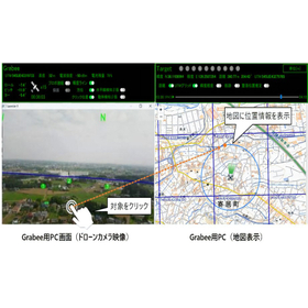
Positioning and displaying the location information of the target object on a map from footage captured by a drone!
By integrating with the small aerial photography drone "SOTEN," it is possible to estimate the position of objects in real-time from the footage captured by the drone and display and record it on a map. Additionally, starting from the latest version 4.0, it supports offline maps, enabling high-precision monitoring and control using map data even in environments with unstable network connections, such as mountainous areas, remote islands, and during disasters. This drone solution is expected to be utilized in the search for victims and missing persons in the field of disaster prevention. 【Features】 ■ Advanced image analysis technology using an image analysis engine ■ Position estimation of objects by combining GPS information and image analysis technology ■ Automatic detection of moving objects from the footage *For more details, please download the PDF or feel free to contact us.

Inquire About This Product
basic information
【Basic Configuration】 ■ ACSL SOTEN ■ Controller for Pilots ■ Controller for Observers ■ Notebook PC for Guardian Operation *For more details, please download the PDF or feel free to contact us.
Price information
*Please inquire about the price.*
Delivery Time
Applications/Examples of results
[Usage Examples] ▪ Disaster and Security (Patrol Monitoring, Post-Disaster Investigation, Search)
catalog(2)
Download All Catalogs

News about this product(2)

Company information

At TENQ SYSTEMS, our philosophy is to "contribute to the development and growth of society through advanced technology and ideas." We provide not only hardware such as drones and related equipment but also high-value-added services through a wide range of solutions, including consulting for implementation and operation.


![[NETIS Products Featured] Field Lloyd Comprehensive Catalog 2025 Edition](https://image.www.ipros.com/public/product/image/7cf/2000958658/IPROS5794486334260890705.jpg?w=280&h=280)

![Cloud Camera "Milmott 360" [NETIS Registered]](https://image.www.ipros.com/public/product/image/2110087/IPROS10748825610804198190.jpg?w=280&h=280)
