iPROS Urban Planning
  • Search for products by classification category

    • Building Materials
      Building Materials
      36699items
    • Facilities
      Facilities
      57502items
    • Lighting and Interior
      Lighting and Interior
      17483items
    • Common materials
      Common materials
      37153items
    • Civil Engineering Materials
      Civil Engineering Materials
      10047items
    • Construction, work and methods
      Construction, work and methods
      28721items
    • Surveys, Measurements, and Services
      Surveys, Measurements, and Services
      29733items
    • IT/Software
      IT/Software
      33257items
    • others
      others
      81099items
    • Store and facility supplies
      Store and facility supplies
      4581items
    • Office and commercial supplies
      Office and commercial supplies
      11685items
    • Hospital and welfare facility supplies
      Hospital and welfare facility supplies
      1025items
    • Logistics Equipment
      Logistics Equipment
      7301items
    • Energy and Resources
      Energy and Resources
      12092items
  • Search for companies by industry

    • Information and Communications
      7309
    • others
      7205
    • Building materials, supplies and fixtures manufacturers
      6584
    • Service Industry
      4711
    • Trading company/Wholesale
      3034
    • Other construction industries
      2431
    • Electrical equipment construction business
      665
    • Interior Design
      519
    • Construction Consultant
      512
    • Facility Design Office
      491
    • retail
      361
    • Architectural design office
      357
    • General contractors and subcontractors
      353
    • Warehousing and transport related industries
      324
    • Electricity, Gas and Water Industry
      287
    • Interior construction business
      279
    • Medical and Welfare
      275
    • Building Management
      266
    • Educational and Research Institutions
      253
    • Renovation and home construction industry
      221
    • Housing manufacturers and construction companies
      220
    • Water supply and drainage construction business
      202
    • Transportation
      166
    • Real Estate Developers
      158
    • Fisheries, Agriculture and Forestry
      129
    • Structural Design Office
      65
    • Finance, securities and insurance
      41
    • self-employed
      31
    • Restaurants and accommodations
      30
    • Mining
      26
    • Public interest/special/independent administrative agency
      20
    • Police, Fire Department, Self-Defense Forces
      17
    • Store and building owners
      9
    • Government
      9
    • Individual
      9
    • Property Owner
      8
  • Special Features
  • Ranking

    • Overall Products Ranking
    • Overall Company Ranking
Search for Products
  • Search for products by classification category

  • Building Materials
  • Facilities
  • Lighting and Interior
  • Common materials
  • Civil Engineering Materials
  • Construction, work and methods
  • Surveys, Measurements, and Services
  • IT/Software
  • others
  • Store and facility supplies
  • Office and commercial supplies
  • Hospital and welfare facility supplies
  • Logistics Equipment
  • Energy and Resources
Search for Companies
  • Search for companies by industry

  • Information and Communications
  • others
  • Building materials, supplies and fixtures manufacturers
  • Service Industry
  • Trading company/Wholesale
  • Other construction industries
  • Electrical equipment construction business
  • Interior Design
  • Construction Consultant
  • Facility Design Office
  • retail
  • Architectural design office
  • General contractors and subcontractors
  • Warehousing and transport related industries
  • Electricity, Gas and Water Industry
  • Interior construction business
  • Medical and Welfare
  • Building Management
  • Educational and Research Institutions
  • Renovation and home construction industry
  • Housing manufacturers and construction companies
  • Water supply and drainage construction business
  • Transportation
  • Real Estate Developers
  • Fisheries, Agriculture and Forestry
  • Structural Design Office
  • Finance, securities and insurance
  • self-employed
  • Restaurants and accommodations
  • Mining
  • Public interest/special/independent administrative agency
  • Police, Fire Department, Self-Defense Forces
  • Store and building owners
  • Government
  • Individual
  • Property Owner
Special Features
Ranking
  • Overall Products Ranking
  • Overall Company Ranking
  • privacy policy
  • terms of service
  • About Us
  • Careers
  • Advertising
  1. Home
  2. Trading company/Wholesale
  3. TENQ SYSTEMS
  4. Product/Service List
Trading company/Wholesale
  • Added to bookmarks

    Bookmarks list

    Bookmark has been removed

    Bookmarks list

    You can't add any more bookmarks

    By registering as a member, you can increase the number of bookmarks you can save and organize them with labels.

    Free membership registration

TENQ SYSTEMS

addressKyoto/Kamigyo-ku, Kyoto-shi/Room 102, Vine Oak Wisdom, 203 Ogawacho
phone075-600-0286
  • Official site
last updated:Mar 11, 2026
TENQ SYSTEMSlogo
  • Contact this company

    Contact Us Online
  • Company information
  • Products/Services(17)
  • catalog(19)
  • news(14)

TENQ SYSTEMS List of Products and Services

  • category

1~17 item / All 17 items

Displayed results

class="retina-image"

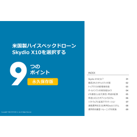
Nine Reasons to Choose the U.S.-Made Drone Skydio X10

Why choose the American-made drone Skydio X10? Here are the key points.

The Skydio X10 is a compact drone equipped with the latest high-performance sensors and cutting-edge AI. It adapts to complex environments and operates safely and securely even in non-GPS conditions, enabling reliable flight and data acquisition. Why choose the Skydio X10? This document summarizes the strengths and features of the aircraft. <Contents> 01 What is the Skydio X10? 02 Thorough security measures 03 Top-class environmental durability 04 All-in-one high-performance camera 05 Redundancy and application expansion through LTE communication 06 Custom options tailored to specific applications 07 Software and extended applications 08 Dedicated Dock system supporting remote operations 09 Training and instruction during operations

  • Non-destructive testing

Added to bookmarks

Bookmarks list

Bookmark has been removed

Bookmarks list

You can't add any more bookmarks

By registering as a member, you can increase the number of bookmarks you can save and organize them with labels.

Free membership registration

Next-generation airspace monitoring system "Sky Sentinel" powered by AI.

Detect small drones and aircraft several kilometers away! Next-generation airspace monitoring using domestic AI and imaging technology.

Sky Sentinel is a next-generation airspace monitoring system that enables real-time surveillance of airspace around airports, maritime areas, and critical facilities. It addresses challenges that were difficult to manage with traditional visual or radar methods by combining AI and imaging technology. It is capable of accurately detecting, identifying, and tracking moving objects such as small drones, birds, and aircraft several kilometers away. It supports a wide range of applications, including bird strike prevention at airports, drone detection at sea, and monitoring of critical facilities like power plants and ports. 【Features】  ■ High-precision detection using domestically developed AI  ■ Compatible with various camera configurations (infrared, visible light, zoom), allowing flexible choices based on purpose and site  ■ Motion detection using CNN*, measurement of distance, direction, and elevation angle, and estimation of the detected object's position  ■ Ability to simultaneously track multiple detected objects according to the PC environment  ■ Display of the detected object's position on a map and immediate issuance of alerts *CNN: Convolutional Neural Network

  • Security cameras and surveillance systems
  • Video Monitoring System
  • Other security systems

Added to bookmarks

Bookmarks list

Bookmark has been removed

Bookmarks list

You can't add any more bookmarks

By registering as a member, you can increase the number of bookmarks you can save and organize them with labels.

Free membership registration

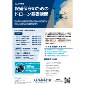
Basic Training for Drone Operations for Equipment Maintenance

From case studies of utilization in the domestic market to the latest legal revisions, professionals in the drone field provide a thorough explanation!

Inputting essential knowledge for operating drones" The operation of drones is no longer limited to specialized operators; many companies are now managing their own drone operations in-house. In this context, training personnel to understand the necessary information for business operations, from legal regulations to operational aspects, has become crucial. This training is designed for companies that utilize drones in their operations, with the aim of "reconfirming operational rules and expanding the scope of utilization.

  • others

Added to bookmarks

Bookmarks list

Bookmark has been removed

Bookmarks list

You can't add any more bookmarks

By registering as a member, you can increase the number of bookmarks you can save and organize them with labels.

Free membership registration

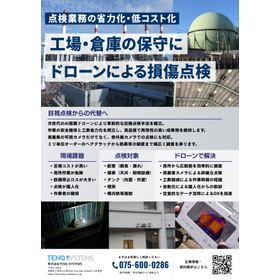
Maintenance of factories and warehouses. Damage inspection using drones.

Streamlining and cost reduction of inspection operations.

**From Visual Inspections to Alternatives** Establishing an innovative close-range inspection method with next-generation AI-equipped drones. We ensure both safety in operations and labor-saving efficiency, providing high-quality and highly reproducible results. We support inspections not only with high-resolution visible cameras but also with infrared cameras. We accept a wide range of investigations, from hairline cracks on the millimeter scale to thermal anomalies. **Challenges on Site** - High scaffolding costs - Dangerous high-altitude work - Significant losses due to equipment downtime - Inspections becoming reliant on specific individuals - Shortage of workers **Inspection Targets** - Piping (corrosion, leaks) - Roofs (ceiling areas, lighting) - Chimneys - On-site tower facilities **Solutions with Drones** - Efficiently surveying large areas from high altitudes - Detailed inspections using high-resolution cameras - Reducing labor hours to shorten work time - Breaking free from reliance on specific individuals through automation - Accelerating digital transformation (DX) through the use of quantitative data

  • maintenance

Added to bookmarks

Bookmarks list

Bookmark has been removed

Bookmarks list

You can't add any more bookmarks

By registering as a member, you can increase the number of bookmarks you can save and organize them with labels.

Free membership registration

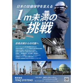
Challenges Under 1 Meter Supporting Japan's Equipment Maintenance

Proposal for innovative inspection and survey operations using cutting-edge AI-equipped drones!

From Visual Inspection to Replacement How far can drones go in inspection and survey operations? Establishing innovative close-range inspection methods with next-generation AI-equipped drones. We achieve both the safety of operators and the reduction of labor hours, providing high-quality and highly reproducible deliverables. Close-range flight, indoor confined spaces, non-GPS environments, dark spaces... It is precisely in the fields where drones have previously faced challenges that we create new value with cutting-edge technology and ideas. That is the mission of our company, TENQ SYSTEMS.

  • Other measuring instruments

Added to bookmarks

Bookmarks list

Bookmark has been removed

Bookmarks list

You can't add any more bookmarks

By registering as a member, you can increase the number of bookmarks you can save and organize them with labels.

Free membership registration

Proximity inspection service using AI-equipped drones

The new standard for inspection and survey operations using cutting-edge AI-equipped drones!

Our company offers inspection and survey services using the latest AI-equipped drone, the "Skydio X10." We can accommodate a wide range of facilities from factories and premises to infrastructure such as bridges and dams. We can perform detailed inspections with high-resolution data within 1 meter of the inspection target. Additionally, we can operate in non-GPS environments such as indoors and enclosed spaces, as well as in dark areas. The acquired data can also be delivered as a three-dimensional model or orthophoto. 【Expected Benefits】 - Replacing work at heights or hazardous locations with drones to reduce the risk of worker accidents. - Minimizing the need for scaffolding and equipment shutdowns, leading to cost reduction through decreased labor hours. - Promoting digital transformation (DX) by utilizing the acquired data for digitization.

  • Non-destructive testing

Added to bookmarks

Bookmarks list

Bookmark has been removed

Bookmarks list

You can't add any more bookmarks

By registering as a member, you can increase the number of bookmarks you can save and organize them with labels.

Free membership registration

Ultimate indoor inspection drone "ELIOS 3"

From 'seeing' to 'measuring.' Accessing people in all places and converting to 3D data in real-time.

The "ELIOS 3" contributes not only to ensuring safety in inspection operations but also to the efficiency of facility operation and management, preventive maintenance, and the realization of digital transformation (DX). The spatial information scanned by the LiDAR sensor is displayed in real-time as a high-precision 3D map, allowing for instant awareness of the position of the inspection and surveying drone "ELIOS 3" and its surrounding environment. With the stable flight algorithm generated by the SLAM engine, pilots can accomplish complex missions with minimal training. 【Optional Payloads】  ■ UT Inspection Payload  ■ Surveying Payload  ■ RAD Payload  ■ Flammable Gas Sensor *For more details, please download the PDF or feel free to contact us.

  • Other measuring instruments
  • Other analytical equipment

Added to bookmarks

Bookmarks list

Bookmark has been removed

Bookmarks list

You can't add any more bookmarks

By registering as a member, you can increase the number of bookmarks you can save and organize them with labels.

Free membership registration

Next-generation AI surveillance drone system "Grabee"

AI image analysis and location estimation solution specialized for forest fire and wildlife damage prevention!

This is a next-generation monitoring solution equipped with new features specialized for forest fire and wildlife damage countermeasures, based on the AI video analysis and position estimation technology developed at Guardian. It is capable of estimating the position of targets in real-time from footage captured by drones and displaying and recording this information on a map. 【Features】 - Position estimation of objects by combining GPS information and video analysis technology - Detection of flames, animals, and wildlife damage from drone footage - Map display of fire areas and calculation of their size *For more details, please download the PDF or feel free to contact us.

  • Analysis and prediction system

Added to bookmarks

Bookmarks list

Bookmark has been removed

Bookmarks list

You can't add any more bookmarks

By registering as a member, you can increase the number of bookmarks you can save and organize them with labels.

Free membership registration

Nine Points to Choose the Domestic Compact Aerial Photography Drone SOTEN (Blue Sky)

Why choose the domestic drone SOTEN? Here are the key points.

SOTEN (Blue Sky) is a domestically produced small aerial photography drone developed under the NEDO project "Development of Safe and Secure Drone Infrastructure Technology," designed for high-security applications. Why choose SOTEN now? This document summarizes the strengths and features of the aircraft. <Contents> 01 What is the small aerial photography drone SOTEN (Blue Sky)? 02 Security measures for domestically produced drones 03 High wind resistance, waterproof and dustproof performance 04 Interchangeable attachment-type camera 05 Expansion of usage applications through LTE communication support 06 A wide range of optional line-up 07 Ground station software "TAKEOFF" 08 Third-party software 09 Implementation of training and instruction during operation

  • Other measuring instruments

Added to bookmarks

Bookmarks list

Bookmark has been removed

Bookmarks list

You can't add any more bookmarks

By registering as a member, you can increase the number of bookmarks you can save and organize them with labels.

Free membership registration

LiDAR-equipped surveying specialized drone "PF2-AE Survey"

A surveying-specific model equipped with Yellow Scan's LiDAR on a domestically produced and secure PF2-AE.

The "PF2-AE Survey" is a surveying-specific drone equipped with a Yellow Scan LiDAR, based on the secure PF2-AE. You can choose from two types of LiDAR according to your needs: - mapper+ - Surveyor Ultra It comes standard with an RGB camera, allowing for point cloud coloring. 【Product Features】 - Follows data security measures developed by SOTEN (Aoten) - Compatible with Yellow Scan LiDAR - Comes standard with two standard transmitters and an ACSL remote ID module - User-friendly interface with excellent operability via a dedicated app - Outstanding flight performance with a maximum airspeed of 20 m/s *For more details, please download the PDF or feel free to contact us.

  • Surveying

Added to bookmarks

Bookmarks list

Bookmark has been removed

Bookmarks list

You can't add any more bookmarks

By registering as a member, you can increase the number of bookmarks you can save and organize them with labels.

Free membership registration

Level 4 flight-capable aircraft "PF2-CAT3"

A Level 4 flight-capable aircraft designed for "safety and security."

The "PF2-CAT3" is an aircraft capable of Level 4 flight by obtaining Type 1 aircraft certification and operating under the rules set forth by a first-class unmanned aircraft pilot. It comes standard with LTE communication, enabling forward and downward video transmission via LTE, and telemetry transmission to monitor the aircraft's status and surrounding environment, allowing for beyond visual line of sight (BVLOS) flight. 【Product Features】  ■ Two-way simultaneous monitoring camera system (forward and downward)  ■ Standard LTE communication for long-distance flight and flight in beyond visual line of sight areas  ■ Network RTK system  ■ Auxiliary safety device (parachute)  ■ User-friendly interface with excellent operability through a dedicated app *For more details, please download the PDF or feel free to contact us.

  • Other elevators and transport systems

Added to bookmarks

Bookmarks list

Bookmark has been removed

Bookmarks list

You can't add any more bookmarks

By registering as a member, you can increase the number of bookmarks you can save and organize them with labels.

Free membership registration

Disaster and Security Drone "PF2-AE"

Equipped with a secure system, a more advanced domestically produced disaster and security drone.

The "PF2-AE Disaster Relief / Patrol" is an advanced disaster and security drone based on the proven PF2, equipped with a secure system developed by SOTEN (Aoten). It features a dedicated multi-gimbal that allows for easy camera replacement. Depending on the application, you can choose from four types of optional cameras. With video transmission and telemetry transmission using LTE communication, connectivity can be secured even in areas with poor visibility. 【Product Features】  ■ Follows data security measures developed by SOTEN (Aoten)  ■ Supports LTE communication for long-distance flight and flight in areas beyond visual line of sight  ■ Enables safe monitoring during beyond visual line of sight flights in mountainous areas and over long distances  ■ User-friendly interface with excellent operability through a dedicated app  ■ Outstanding flight performance with a maximum airspeed of 20m/s *For more details, please download the PDF or feel free to contact us.

  • Other measuring instruments

Added to bookmarks

Bookmarks list

Bookmark has been removed

Bookmarks list

You can't add any more bookmarks

By registering as a member, you can increase the number of bookmarks you can save and organize them with labels.

Free membership registration

Infrastructure inspection drone "PF2-AE"

A domestically developed infrastructure inspection drone equipped with a secure system and advanced features.

The "PF2-AE Inspection" is an advanced infrastructure inspection drone based on the highly proven PF2, equipped with a secure system developed by SOTEN (Sōten). It features a dedicated multi-gimbal that allows for easy camera replacement. You can choose from four types of optional cameras depending on your needs. As a safety measure, it comes standard with a 360° horizontal LiDAR, enabling collision avoidance during inspections of nearby structures. 【Product Features】 - Follows the data security measures developed by SOTEN (Sōten) - Enhanced safety with long-range 360° horizontal LiDAR - Safe monitoring during visual flight beyond visual line of sight in mountainous areas and over long distances - User-friendly interface with excellent operability via a dedicated app - Outstanding flight performance with a maximum airspeed of 20 m/s *For more details, please download the PDF or feel free to contact us.

  • Other measuring instruments

Added to bookmarks

Bookmarks list

Bookmark has been removed

Bookmarks list

You can't add any more bookmarks

By registering as a member, you can increase the number of bookmarks you can save and organize them with labels.

Free membership registration

Infrastructure logistics drone "PF2-AE"

A domestically produced infrastructure logistics drone equipped with a secure system and more advanced features.

The "PF2-AE Delivery" is an advanced infrastructure logistics drone equipped with a secure system developed by SOTEN (Sōten), based on the highly proven PF2. It comes standard with a dedicated logistics mechanism and a transport box, capable of carrying and transporting items weighing up to 1.5 kg. Two transmitters are included as standard, allowing for safe monitoring at two locations (takeoff and landing points). 【Product Features】 - Follows data security measures developed by SOTEN (Sōten) - Supports LTE communication for long-distance flights and flights beyond visual line of sight - Enables safe monitoring during flights beyond visual line of sight in mountainous areas and over long distances - User-friendly interface with excellent operability through a dedicated app - Outstanding flight performance with a maximum airspeed of 18 m/s and an IP55 equivalent protection rating *For more details, please download the PDF or feel free to contact us.

  • Material handling systems and equipment

Added to bookmarks

Bookmarks list

Bookmark has been removed

Bookmarks list

You can't add any more bookmarks

By registering as a member, you can increase the number of bookmarks you can save and organize them with labels.

Free membership registration

Drone detection system "Drone ID Tracker"

Detecting the remote ID of a drone in flight! Displaying aircraft information and location on a map in real time.

The "Drone ID Tracker" can detect 99.9% of drones within Japan. It is capable of detecting the remote ID of flying drones and displaying aircraft information and location on a map. It is expected to be utilized for monitoring the illegal use of drones and unauthorized intrusions into properties in the field of security. Please feel free to contact us if you have any inquiries. 【Features】  ■ Start detecting remote IDs simply by connecting to the internet  ■ Display flying drones from a management PC and monitor flight status  ■ Receive notifications on a smartphone app, allowing for immediate response *For more details, please download the PDF or feel free to contact us.

  • Analysis and prediction system

Added to bookmarks

Bookmarks list

Bookmark has been removed

Bookmarks list

You can't add any more bookmarks

By registering as a member, you can increase the number of bookmarks you can save and organize them with labels.

Free membership registration

Domestic compact aerial photography drone "SOTEN (Blue Sky)"

A secure domestic drone supporting the future! An easy-to-use user interface.

"SOTEN" is a domestically produced small aerial photography drone developed under the NEDO project "Development of Safe and Secure Drone Infrastructure Technology," featuring high-security capabilities. In addition to security measures for flight data, imaging data, and communications, it allows for long-distance and beyond-visual-line-of-sight control using LTE communication. Furthermore, it offers a wide range of expandability, including a one-touch switchable camera, top-mounted installation, and offline maps. Please feel free to contact us if you have any requests. 【Features】  ■ Security measures and communication encryption based on ISO15408  ■ Excellent flight performance with a maximum airspeed of 15 m/s and protection rating IP43  ■ One-touch camera switching and a wide selection of cameras  ■ Expandability with LTE communication, RTK, and offline maps  ■ User-friendly interface with excellent operability via the dedicated app "TakeOff" *For more details, please download the PDF or feel free to contact us.

  • Other measuring instruments

Added to bookmarks

Bookmarks list

Bookmark has been removed

Bookmarks list

You can't add any more bookmarks

By registering as a member, you can increase the number of bookmarks you can save and organize them with labels.

Free membership registration

Outdoor surveillance drone system "Guardian"

Positioning and displaying the location information of the target object on a map from footage captured by a drone!

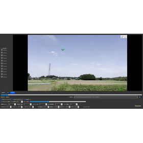
By integrating with the small aerial photography drone "SOTEN," it is possible to estimate the position of objects in real-time from the footage captured by the drone and display and record it on a map. Additionally, starting from the latest version 4.0, it supports offline maps, enabling high-precision monitoring and control using map data even in environments with unstable network connections, such as mountainous areas, remote islands, and during disasters. This drone solution is expected to be utilized in the search for victims and missing persons in the field of disaster prevention. 【Features】  ■ Advanced image analysis technology using an image analysis engine  ■ Position estimation of objects by combining GPS information and image analysis technology  ■ Automatic detection of moving objects from the footage *For more details, please download the PDF or feel free to contact us.

  • Security cameras and surveillance systems

Added to bookmarks

Bookmarks list

Bookmark has been removed

Bookmarks list

You can't add any more bookmarks

By registering as a member, you can increase the number of bookmarks you can save and organize them with labels.

Free membership registration
Prev 1 Next
  • Contact this company

    Contact Us Online

Products

  • Search for Products

Company

  • Search for Companies

Special Features

  • Special Features

Ranking

  • Overall Products Ranking
  • Overall Company Ranking

support

  • site map
IPROS
  • privacy policy Regarding external transmission of information
  • terms of service
  • About Us
  • Careers
  • Advertising
IPROS Services
  • >IPROS GMS | Search site for the manufacturing industry
  • >IPROS | Search site for the B2B industry
COPYRIGHT © 2001-2026 IPROS CORPORATION ALL RIGHTS RESERVED.
Please note that the English text on this page is automatically translated and may contain inaccuracies.