Automate the extraction and polygonization of object shapes from aerial photographs using AI!
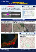
Real-Time Geo Tracer is a feature detection and geo-coding tool that utilizes the instance segmentation technology "Mask_R-CNN." It extracts specific features from a large volume of aerial photographs and records them as geospatial data. In addition to feature extraction, it traces the boundaries of features to create polygons, allowing for more accurate understanding of feature characteristics such as area calculation. * Mask_R-CNN is a technology that performs class classification and segmentation for each detected object individually.

Inquire About This Product
basic information
■ Features of Real-Time Geo Tracer - Simultaneously performs object detection, classification, and segmentation, while also capturing the class, location coordinates, and shape of detected features. - Saves the segmented object boundaries in polygon form in GeoJson format. - Recognizes multi-part polygons as a single polygon with a unique ID (not possible with general semantic segmentation). - Allows for a more detailed understanding of the actual situation compared to rectangular object detection by obtaining area for each feature. - Extracted feature polygons can have their vertex count reduced using the Douglas-Peucker algorithm. ■ Examples of detectable features from aerial photographs - Buildings - Ground-mounted mega solar panels - Solar panels installed on buildings - Greenhouses, glasshouses, etc. For other features, please consult us. ■ Aerial photograph services available for analysis - Geospatial Information Authority of Japan maps - GEOSPACE CDS - Other aerial photographs stored on various disks.
Price information
Prices may vary depending on the scope and subject matter, so please feel free to contact us.
Delivery Time
※Please contact us. *Delivery times may vary depending on the scope, so feel free to reach out to us.
Applications/Examples of results
■Application Areas ・ Fixed Asset Field (Object Movement Interpretation) ・ Disaster Prevention and Mitigation Field (Landslide and Slope Failure Interpretation) ・ Social Infrastructure Field (Crack Diagnosis of Roads, Bridges, Tunnels, etc.)
catalog(3)
Download All Catalogs

Company information

Orbital Net develops IT services in the fields of mapping, surveying, and construction consulting. By selecting, combining, and customizing a range of open-source software for geospatial systems known as FOSS4G as needed, we can provide optimal systems. Furthermore, by integrating these technologies with AI, we aim not only to improve and automate operations but also to achieve things that were previously impossible, ultimately continuing to create new value that has never existed before.


![[Analysis Case] Frequency Response Dynamic Magnetic Field Analysis of Magnetic Shielding](https://image.www.ipros.com/public/product/image/68b/2000763926/IPROS02180885106606877203.png?w=280&h=280)


![[For Factories] Waterproof Integrated Platform Base "Connecting Disk ADC"](https://image.www.ipros.com/public/product/image/83b/2001511414/IPROS86056821509702777928.jpeg?w=280&h=280)
![[Security Measures] Camera with Solar Panel that Doesn't Require Power 'Solar Eyes'](https://image.www.ipros.com/public/product/image/2101191/IPROS4106816969100601178.png?w=280&h=280)