Manage work vehicles with high-precision positioning! No need to install base stations. Increased productivity and cost reduction!
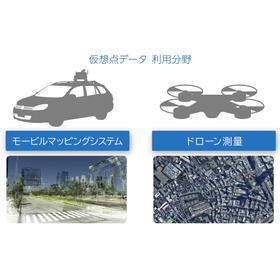
Our company provides a service that receives and analyzes real-time data from electronic reference points released by the Geospatial Information Authority of Japan, delivering high-precision positioning correction data. With our unique technology, we respond to demands for improved accuracy and cost reduction, offering network-based RTK positioning correction data suitable for our customers' businesses. Using our services, various activities such as general surveying, land and house surveyor work, and civil engineering construction are being conducted, and we have compiled some case studies. This time, we have added examples of utilization in the "UAV/Drone" field for unmanned operations. 【Examples of Utilization for Unmanned Operations】 ■ Application to Firefighting Robot Systems In fires where firefighters cannot approach, the robot makes decisions and acts on its own. *For more details on the case studies, please download the materials. Feel free to contact us with any inquiries.

Inquire About This Product
basic information
【Mechanism of Network RTK】 ■ Continuous monitoring of error factors 24 hours a day ■ Sending the approximate location of the surveying site to the Genoa center ■ Distributing correction information for relative positioning using reference stations with virtual point and surface correction parameter methods ■ Acquiring high-precision location information with correction data *For more details, please refer to the catalog or feel free to contact us.
Price range
Delivery Time
Applications/Examples of results
For more details, please refer to the catalog or feel free to contact us.
catalog(11)
Download All Catalogs


Company information

Genova Corporation is a company that provides high-precision location information services using GNSS satellites. Currently, applications utilizing network-based RTK (Real-Time Kinematic) are expanding. Our high-precision positioning data services are used in numerous fields, including autonomous driving, precision agriculture, i-Construction/ICT construction, UAVs, general surveying, civil engineering, research work, land and building surveying, and archaeological investigations.