iPROS Urban Planning
  • Search for products by classification category

    • Building Materials
      Building Materials
      36420items
    • Facilities
      Facilities
      58095items
    • Lighting and Interior
      Lighting and Interior
      17661items
    • Common materials
      Common materials
      37179items
    • Civil Engineering Materials
      Civil Engineering Materials
      10187items
    • Construction, work and methods
      Construction, work and methods
      29267items
    • Surveys, Measurements, and Services
      Surveys, Measurements, and Services
      29650items
    • IT/Software
      IT/Software
      33661items
    • others
      others
      96089items
    • Store and facility supplies
      Store and facility supplies
      4652items
    • Office and commercial supplies
      Office and commercial supplies
      11743items
    • Hospital and welfare facility supplies
      Hospital and welfare facility supplies
      1067items
    • Logistics Equipment
      Logistics Equipment
      7381items
    • Energy and Resources
      Energy and Resources
      11964items
  • Search for companies by industry

    • Information and Communications
      7296
    • others
      7236
    • Building materials, supplies and fixtures manufacturers
      6677
    • Service Industry
      4796
    • Trading company/Wholesale
      3103
    • Other construction industries
      2460
    • Electrical equipment construction business
      766
    • Construction Consultant
      655
    • General contractors and subcontractors
      593
    • Interior Design
      520
    • Facility Design Office
      487
    • Housing manufacturers and construction companies
      450
    • Architectural design office
      368
    • retail
      364
    • Warehousing and transport related industries
      333
    • Building Management
      303
    • Electricity, Gas and Water Industry
      286
    • Interior construction business
      283
    • Medical and Welfare
      277
    • Educational and Research Institutions
      256
    • Renovation and home construction industry
      226
    • Water supply and drainage construction business
      203
    • Transportation
      179
    • Real Estate Developers
      170
    • Fisheries, Agriculture and Forestry
      136
    • Structural Design Office
      65
    • Finance, securities and insurance
      41
    • Restaurants and accommodations
      33
    • self-employed
      30
    • Mining
      26
    • Public interest/special/independent administrative agency
      20
    • Police, Fire Department, Self-Defense Forces
      17
    • Property Owner
      9
    • Store and building owners
      9
    • Government
      9
    • Individual
      9
  • Special Features
  • Ranking

    • Overall Products Ranking
    • Overall Company Ranking
Search for Products
  • Search for products by classification category

  • Building Materials
  • Facilities
  • Lighting and Interior
  • Common materials
  • Civil Engineering Materials
  • Construction, work and methods
  • Surveys, Measurements, and Services
  • IT/Software
  • others
  • Store and facility supplies
  • Office and commercial supplies
  • Hospital and welfare facility supplies
  • Logistics Equipment
  • Energy and Resources
Search for Companies
  • Search for companies by industry

  • Information and Communications
  • others
  • Building materials, supplies and fixtures manufacturers
  • Service Industry
  • Trading company/Wholesale
  • Other construction industries
  • Electrical equipment construction business
  • Construction Consultant
  • General contractors and subcontractors
  • Interior Design
  • Facility Design Office
  • Housing manufacturers and construction companies
  • Architectural design office
  • retail
  • Warehousing and transport related industries
  • Building Management
  • Electricity, Gas and Water Industry
  • Interior construction business
  • Medical and Welfare
  • Educational and Research Institutions
  • Renovation and home construction industry
  • Water supply and drainage construction business
  • Transportation
  • Real Estate Developers
  • Fisheries, Agriculture and Forestry
  • Structural Design Office
  • Finance, securities and insurance
  • Restaurants and accommodations
  • self-employed
  • Mining
  • Public interest/special/independent administrative agency
  • Police, Fire Department, Self-Defense Forces
  • Property Owner
  • Store and building owners
  • Government
  • Individual
Special Features
Ranking
  • Overall Products Ranking
  • Overall Company Ranking
  • privacy policy
  • terms of service
  • About Us
  • Careers
  • Advertising
  1. Home
  2. Information and Communications
  3. ソフトバンク 本社
  4. Product/Service List
Information and Communications
  • Added to bookmarks

    Bookmarks list

    Bookmark has been removed

    Bookmarks list

    You can't add any more bookmarks

    By registering as a member, you can increase the number of bookmarks you can save and organize them with labels.

    Free membership registration

ソフトバンク 本社

addressTokyo/Minato-ku/1-7-1 Kaigan, Tokyo Port City Takeshiba Office Tower
phone03-6889-2000
  • Special site
  • Official site
last updated:May 11, 2026
ソフトバンクlogo
  • Contact this company

    Contact Us Online
  • Company information
  • Products/Services(25)
  • catalog(17)
  • news(5)

ソフトバンク List of Products and Services

  • category

1~6 item / All 6 items

Displayed results

Filter by category
高精度測位サービス「ichimill(イチミル)」 高精度測位サービス「ichimill(イチミル)」
高精度測位サービス「ichimill(イチミル)」導入事例 高精度測位サービス「ichimill(イチミル)」導入事例
ALES センチメートル級測位サービス ALES センチメートル級測位サービス
ALES 後処理データサービス ALES 後処理データサービス
UWB屋内測位ソリューション UWB屋内測位ソリューション
ALES センチメートル級測位サービス

ALES センチメートル級測位サービス

個人向けの高精度測位サービス。

Centimeter-level positioning service

Achieving high-precision positioning with an accuracy of a few centimeters using RTK technology.

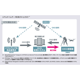
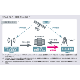
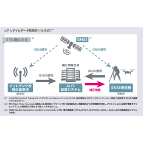
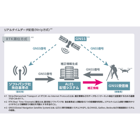
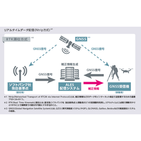
The "centimeter-level positioning service" provided by ALES is a service that delivers correction information generated by the "ALES distribution system" based on signals received by SoftBank's unique reference points (fixed stations) to GNSS receivers mounted on agricultural machinery, construction equipment, autonomous vehicles, drones, etc., via the internet (Ntrip method). It is only available to individual customers. By utilizing this correction information along with the signals received by the GNSS receiver, it is possible to perform RTK positioning with high precision, achieving accuracy within a few centimeters in real-time. Additionally, the correction information generated by the "ALES distribution system" can be linked to GNSS receivers via a smartphone.

Added to bookmarks

Bookmarks list

Bookmark has been removed

Bookmarks list

You can't add any more bookmarks

By registering as a member, you can increase the number of bookmarks you can save and organize them with labels.

Free membership registration

Centimeter-level positioning service for construction sites

Improving construction site construction accuracy with RTK technology.

In the construction industry, the accurate placement and dimension management of structures significantly affect the quality and safety of the work. Particularly in situations that require precise surveying and marking, even slight errors are unacceptable. Inaccurate measurements can lead to rework and discrepancies with the design, resulting in project delays and increased costs. Our service addresses these challenges by utilizing RTK technology to provide real-time, high-precision positioning with errors of just a few centimeters. 【Application Scenarios】 - Precise surveying and marking - Guidance of heavy machinery and construction equipment - Surveying and inspection using drones 【Benefits of Implementation】 - Improved construction accuracy - Reduced project duration and costs - Enhanced safety of operations

Added to bookmarks

Bookmarks list

Bookmark has been removed

Bookmarks list

You can't add any more bookmarks

By registering as a member, you can increase the number of bookmarks you can save and organize them with labels.

Free membership registration

Centimeter-level positioning service for agriculture

High-precision positioning with an error of a few centimeters that supports precise distribution.

In the agricultural sector, uniform and accurate application of pesticides and fertilizers is required. In particular, applying them evenly across the entire field is crucial for ensuring uniform crop growth and stabilizing yields. Improper application can lead to excessive spraying in some areas or missed spots, which can result in harvest losses and increased costs. Our "centimeter-level positioning service" utilizes RTK technology to achieve real-time, high-precision positioning with an error of just a few centimeters, supporting precise application tasks. 【Usage Scenarios】 - Navigation for precise application routes using agricultural machinery - Management of optimal application amounts for each field - Improvement of work efficiency and reduction of human errors 【Benefits of Implementation】 - Cost reduction through proper use of pesticides and fertilizers - Promotion of crop growth and stabilization of yields through uniform application - Labor-saving and improved accuracy in operations

Added to bookmarks

Bookmarks list

Bookmark has been removed

Bookmarks list

You can't add any more bookmarks

By registering as a member, you can increase the number of bookmarks you can save and organize them with labels.

Free membership registration

Centimeter-level positioning service for surveying

High-precision positioning with an error of a few centimeters for terrain mapping.

In the surveying industry, obtaining detailed and accurate topographic data is essential for terrain mapping. Particularly, to efficiently grasp extensive terrain and create high-precision maps, it is important to minimize positional errors. Inaccurate survey data can lead to rework in design and development, as well as delays in planning. Our "centimeter-level positioning service" utilizes RTK technology to achieve high-precision positioning with errors of just a few centimeters in real-time, addressing these challenges. 【Application Scenarios】 - Extensive terrain surveying - Detailed terrain mapping - Surveying of construction sites and planned development areas 【Benefits of Implementation】 - Acquisition of high-precision topographic data - Increased efficiency in surveying operations - Reduction in data creation time

Added to bookmarks

Bookmarks list

Bookmark has been removed

Bookmarks list

You can't add any more bookmarks

By registering as a member, you can increase the number of bookmarks you can save and organize them with labels.

Free membership registration

Centimeter-level positioning service for drones

Support for precise drone flight with RTK technology.

In precision flying with drones, accurate positioning information is essential. Especially for applications such as aerial photography, surveying, and inspections, even a few centimeters of error may not be acceptable. Inaccurate positioning information can lead to mission failures or the need for rework. Our "centimeter-level positioning service" utilizes RTK technology to achieve high-precision positioning with an error of just a few centimeters in real-time, supporting precise drone flights. 【Use Cases】 - High-precision aerial photography - Detailed terrain surveying - Precise inspections of structures 【Benefits of Implementation】 - Increased mission success rate - Improved work efficiency - Enhanced data accuracy

Added to bookmarks

Bookmarks list

Bookmark has been removed

Bookmarks list

You can't add any more bookmarks

By registering as a member, you can increase the number of bookmarks you can save and organize them with labels.

Free membership registration

Centimeter-level positioning service for infrastructure inspection

Support for abnormal detection in infrastructure inspections with high-precision positioning within a few centimeters of error.

In infrastructure inspections, accurately understanding the deterioration and abnormal areas of equipment is essential for ensuring safety and improving maintenance efficiency. Particularly, to grasp the detailed condition of extensive structures and not miss subtle changes, data collection based on high-precision location information is required. Our centimeter-level positioning service addresses these challenges by providing real-time, high-precision positioning with an error of just a few centimeters, supporting the detection of anomalies in infrastructure. 【Usage Scenarios】 - Inspection of structures such as bridges, tunnels, and roads - Patrol of infrastructure facilities like power lines and pipelines - Wide-area infrastructure condition assessment using drones - Provision of high-precision location information for inspection data 【Benefits of Implementation】 - Improved accuracy in identifying abnormal areas - Increased efficiency and speed of inspection work - Development of accurate maintenance plans based on detailed data - Enhanced safety and reduced accident risks

Added to bookmarks

Bookmarks list

Bookmark has been removed

Bookmarks list

You can't add any more bookmarks

By registering as a member, you can increase the number of bookmarks you can save and organize them with labels.

Free membership registration
Prev 1 Next
  • CAD CAE 3Dソフト そのままVR化 EasyVR
  • 高校生に直接出会える! 国内最大級の合同企業説明会 ジョブドラフトFes 全国19都府県で実施!
    • Contact this company

      Contact Us Online

    Products

    • Search for Products

    Company

    • Search for Companies

    Special Features

    • Special Features

    Ranking

    • Overall Products Ranking
    • Overall Company Ranking

    support

    • site map
    IPROS
    • privacy policy Regarding external transmission of information
    • terms of service
    • About Us
    • Careers
    • Advertising
    IPROS Services
    • >IPROS GMS | Search site for the manufacturing industry
    • >IPROS | Search site for the B2B industry
    COPYRIGHT © 2001-2026 IPROS CORPORATION ALL RIGHTS RESERVED.
    Please note that the English text on this page is automatically translated and may contain inaccuracies.