Utilizing a 3D laser scanner for on-site surveys of renovation work and current documentation!
By utilizing 3D laser scanners and point clouds for on-site surveys and current condition mapping, we can solve the labor shortage problem and achieve shorter construction periods and cost reductions!
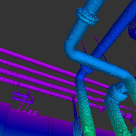
【Project Methodology and Procedures】 1. 3D measurement using a 3D laser scanner 2. Synthesis and verification of the acquired point cloud 3. Noise removal of floating objects and moving objects within the point cloud 4. Creation of as-built data 5. Modeling from the point cloud to create 3D drawings 【Deliverables】 ■ As-built data (point cloud and 360° panoramic photos) ■ Drawing data modeled from the point cloud (compatible with 3D CAD/BIM) 【Details of Deliverables】 ■ As-built data (point cloud) - A collection of points with X, Y, Z coordinates and RGB coordinates obtained from the camera - Allows 3D display on a computer, enabling viewpoint changes and cross-section creation for viewing, with high-precision dimension measurement possible ■ As-built data (360° panoramic photos) - 360° panoramic photos taken from the position where the laser scanner was installed - Can be referenced overlaid on the point cloud, allowing for dimension measurement on the photos ■ 3D CAD drawings - CAD drawings that accurately reflect the current state of the building's structure, finishes, and equipment - High-precision piping modeling using automated piping modeling software - Created as BIM-compatible CAD data (using Revit, Rebro, Tfas, AutoCAD, Navisworks, etc.)
- Company:テクノブレイン
- Price:Other


![Point cloud processing software [Elizion Infipoints]](https://image.www.ipros.com/public/product/image/b80/2000703689/IPROS81822048832541451102.jpeg?w=280&h=280)
![[Discontinued] 3D Laser Scanner Trimble TX8/TX6](https://image.www.ipros.com/public/product/image/c53/2000703696/IPROS67406624266237668571.jpeg?w=280&h=280)


