Information on "3D Laser Scanner Measurement"
3D laser scanner technology capable of high-speed, efficient, and highly accurate measurements over a wide range!
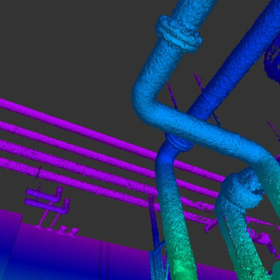
At NAO Planning Co., Ltd., all data is digital data, allowing us to significantly reduce the effort required for creating as-built data through our "3D Laser Scanning Measurement." Three-dimensional coordinates can be obtained safely and in a short time. This technology is utilized in various tasks such as cultural heritage measurement and disaster recovery. Additionally, we can perform extensive measurements that were not possible with traditional total stations, achieving high-speed, efficient, and high-precision results at 50,000 points per second with 360° x 270° full dome measurement. 【Features】 ■ Significantly reduces the effort required for creating as-built data since everything is digital data. ■ More cost-effective CG creation compared to traditional methods, enabling various applications. ■ Makes a significant contribution to the restoration and preservation planning of cultural heritage sites such as castles. *Please feel free to contact us for more details.
- Company:NAO企画
- Price:Other


![[Case Study Collection] GS-1](https://image.www.ipros.com/public/product/image/054/2001416936/IPROS12412343509502025986.png?w=280&h=280)


![[Reference Case] Layout Plan for Safety Measures within the Plant](https://image.www.ipros.com/public/product/image/875/2001181640/IPROS84841703119831472482.jpeg?w=280&h=280)