New MR technology for surveying support! Significant reduction in time and costs!
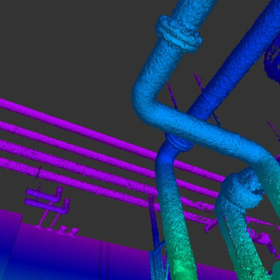
With our surveying system, using scanners and GNSS, it is possible to grasp the current situation in about two weeks, instead of the usual one month. While viewing the created 3D model with MR (Mixed Reality) technology, we efficiently support the positioning of the current situation. Additionally, we offer this service at a low cost, which typically ranges from 5 to 10 million yen. 【Features】 ■ Reduces the number of construction projects and cuts construction and labor costs ■ Enables in-house surveying in a short period with an easy-to-use surveying system ■ Significantly reduces personnel, time, and costs with a surveying system that does not require outsourcing, etc. *For more details, please download the PDF or feel free to contact us.

Inquire About This Product
basic information
【Provided Plans】 ■1. Surveying ■2. Comparison of Current Conditions and Plans ・Synthesis ・Volume Calculation ・Elevation Difference ・Understanding of Construction Procedures, etc. ■3. Transforming the Plan into a 3D Model for VR/MR *For more details, please download the PDF or feel free to contact us.
Price range
Delivery Time
Applications/Examples of results
For more details, please download the PDF or feel free to contact us.
catalog(1)
Download All Catalogs
Company information

At Assess Co., Ltd., we have revamped the traditional surveying style by adopting automatic tracking total stations, electronic levels, and GNSS to meet the requirements of reducing human error, cutting costs, and achieving high precision. Additionally, we can now seamlessly complete everything from three-dimensional current condition measurements using 3D scanners to volume calculations using 3D and CAD. Please feel free to contact us if you have any inquiries.