![[Subsidy-eligible product] Laser scanner Leica RTC360](https://image.www.ipros.com/public/product/image/fe7/2000525603/IPROS84924237134814612648.png?w=280&h=280)
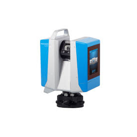
[Subsidy-eligible product] Laser scanner Leica RTC360
Speedy, portable, and high precision! Equipped with seamless automatic data transfer functionality from the field to the office.
The "Leica RTC360 Laser Scanner" features a measurement speed of up to 2 million points per second and an advanced HDR imaging system, allowing for the acquisition of color 3D point cloud data in just 2 minutes. With its target-free automatic registration function powered by VIS technology and seamless automatic data transfer from the field to the office, it significantly reduces field measurement time and greatly enhances productivity. 【Features】 ■ Achieves 3D reality capture in a short time ■ Portable design and foldable dedicated tripod can be stored in a backpack ■ Can be carried anywhere ■ Simply go to the site and perform a quick and easy scan with a single button operation ★ This product qualifies as surveying equipment eligible for "subsidy utilization" upon purchase. It may be available for purchase at 1/2 to 1/3 of the regular price! If you are interested, please feel free to contact us. * For more details, please refer to the PDF materials or feel free to reach out to us.
- Company:横浜測器 本社
- Price:Other