
List of Investigation, testing and inspection products
- classification:Investigation, testing and inspection
586~630 item / All 5979 items


Natural wood endless tape with a thickness of 0.9 to 3 mm. It contributes to improved yield and productivity as a substitute for solid wood for the edges of furniture and fixtures.


- others


By simply increasing the formwork, we can achieve a variety of variations. Formwork costs are reduced, and productivity is improved! We respond to various site needs with multifunctionality.
- Gutters and U-shaped gutters
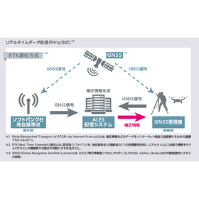

Support for precise drone flight with RTK technology.
- Surveying
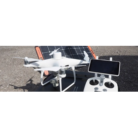
High-precision RTK-GNSS available for a monthly fee of several thousand yen: 'ichimill' thoroughly tested by Kōbe Seiko for drone surveying and point cloud measurement.
This article was published in Construction IT World on March 18, 2022. SoftBank offers a high-precision positioning service called "ichimill," which provides "correction information" used in "RTK-GNSS" capable of high-precision surveying. Despite its accuracy of just a few centimeters, the usage fee is surprisingly low at several thousand yen per month. A technical sales representative from Kobe Seiko, a surveying equipment sales company based in Kobe, Hyogo Prefecture, thoroughly tested the capabilities of ichimill using point cloud measurements with drones and 3D laser scanners.
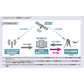
High-precision positioning with an error of a few centimeters for terrain mapping.
- Surveying
High-precision RTK-GNSS available for a monthly fee of several thousand yen: 'ichimill' thoroughly tested by Kōbe Seiko for drone surveying and point cloud measurement.
This article was published in Construction IT World on March 18, 2022. SoftBank offers a high-precision positioning service called "ichimill," which provides "correction information" used in "RTK-GNSS" capable of high-precision surveying. Despite its accuracy of just a few centimeters, the usage fee is surprisingly low at several thousand yen per month. A technical sales representative from Kobe Seiko, a surveying equipment sales company based in Kobe, Hyogo Prefecture, thoroughly tested the capabilities of ichimill using point cloud measurements with drones and 3D laser scanners.
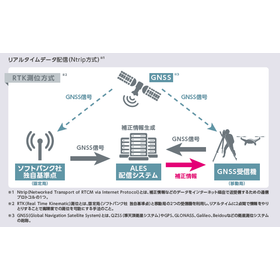
High-precision positioning with an error of a few centimeters that supports precise distribution.
- Surveying
High-precision RTK-GNSS available for a monthly fee of several thousand yen: 'ichimill' thoroughly tested by Kōbe Seiko for drone surveying and point cloud measurement.
This article was published in Construction IT World on March 18, 2022. SoftBank offers a high-precision positioning service called "ichimill," which provides "correction information" used in "RTK-GNSS" capable of high-precision surveying. Despite its accuracy of just a few centimeters, the usage fee is surprisingly low at several thousand yen per month. A technical sales representative from Kobe Seiko, a surveying equipment sales company based in Kobe, Hyogo Prefecture, thoroughly tested the capabilities of ichimill using point cloud measurements with drones and 3D laser scanners.
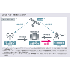
Improving construction site construction accuracy with RTK technology.
- Surveying
High-precision RTK-GNSS available for a monthly fee of several thousand yen: 'ichimill' thoroughly tested by Kōbe Seiko for drone surveying and point cloud measurement.
This article was published in Construction IT World on March 18, 2022. SoftBank offers a high-precision positioning service called "ichimill," which provides "correction information" used in "RTK-GNSS" capable of high-precision surveying. Despite its accuracy of just a few centimeters, the usage fee is surprisingly low at several thousand yen per month. A technical sales representative from Kobe Seiko, a surveying equipment sales company based in Kobe, Hyogo Prefecture, thoroughly tested the capabilities of ichimill using point cloud measurements with drones and 3D laser scanners.
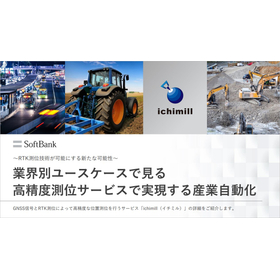
Industrial automation realized by high-precision positioning services seen through industry-specific use cases.
- Surveying
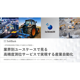
Nakanoshima Robot Challenge 2023 Report: The Present and Future of Robot Autonomous Movement through High-Precision Satellite Positioning
On January 28, 2024, the main running event of the outdoor autonomous mobile robot demonstration experiment "Nakanoshima Robot Challenge" was held at Nakanoshima Park in Osaka City. The "Nakanoshima Robot Challenge" is conducted as part of technology development aimed at the practical application of autonomous mobile robots, providing a public experimental platform for universities and companies. Participants tested their skills towards the realization of "automatic garbage collection robots," aiming for a demonstration at the 2025 World Expo. SoftBank and ALES (a company established through joint investment by SoftBank and Enable, Inc.) have participated as sponsors of this event since 2020, providing technical support related to robot positioning, correction information for the centimeter-level positioning service "ichimill," and lending specialized terminals. This article will introduce the event's proceedings and the autonomous movement control of robots using high-precision location information.
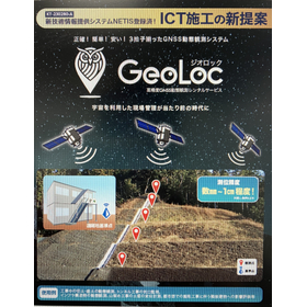

Utilizing space for site management improves the accuracy of surveying.
- Surveying
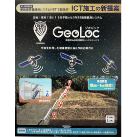
Utilizing space for site management, also for maintenance management.
- Surveying


Refrigeration and Air Conditioning Training Equipment
- Analysis and prediction system
![[Case Study] Tokyu Construction Co....](https://image.www.ipros.com/public/product/image/2083202/IPROS5334995245916406930.png?w=280&h=280)

Aiming for on-site completion of drone surveying operations! The ICT Promotion Group has chosen the option "Kumiki."
- Other measuring instruments
- Other Software
- Surveying
![[Case Study] Kabuki Construction Co...](https://image.www.ipros.com/public/product/image/2083202/IPROS15281676821080509581.jpg?w=280&h=280)
Introducing a case where work style was improved with a reduction of over 90% in working hours!
- Other measuring instruments
- Other Software
- Surveying
![[Case Study] Rinkai Nissan Construc...](https://image.www.ipros.com/public/product/image/2083202/IPROS11632372015055546399.jpg?w=280&h=280)
Improving work styles with a reduction of over 90% in working hours! Introducing the case study of Kumiki.
- Other measuring instruments
- Other Software
- Surveying


Thermal sensing camera that instantly detects the surface temperature of individuals | Records temperature results in images and videos | Ideal for temperature measurement in schools, hospitals, facto...
- Security cameras and surveillance systems
- Analysis and prediction system
- Security guards and entrance/exit management
Smart surveillance device that enables AI analysis, thermal measurement, personal authentication, and access control.
We offer a lineup that meets diverse on-site needs, including wide-angle panoramic cameras, thermal cameras, facial recognition terminals, and acoustic cameras. 【Product Overview】 ■ Acoustic Camera BS-DL56 Visualizes air leaks, compressed air leaks, gas leaks, and partial discharges using ultrasound. ■ Thermal Camera BS-2WE1217-3/TD Visualizes the surface temperature of individuals. ■ Panoramic Camera BS-2FG2387J2S-OVX/VO Deters intruders with strobe lights and warning sounds. ■ Panoramic Camera BS-2FG2W167J3S-OLV2XB/VO Minimizes blind spots with an ultra-wide angle of 180°. ■ Network Video Recorder (NVR) iBS-6704QAL-L/ED Automatically detects when helmets are not worn. ■ PTRZ (Pan, Tilt, Rotate, Zoom) Dome Camera BS-2FG2747J3-OLSWUCV2XB/VO Flexible monitoring from wide-angle to telephoto with electric varifocal (variable focus). ■ Facial Recognition Terminal BS-N1W673WGA-W Enables non-contact high-speed authentication even while wearing a mask. (*) For more details, please refer to the related links and related products.
Visualization of air leaks, gas leaks, and compressed air leaks using ultrasound | Instant identification from inspection and detection of partial discharge leading to equipment failure to abnormal de...
- Gas leak device
- maintenance
- Analysis and prediction system
Smart surveillance device that enables AI analysis, thermal measurement, personal authentication, and access control.
We offer a lineup that meets diverse on-site needs, including wide-angle panoramic cameras, thermal cameras, facial recognition terminals, and acoustic cameras. 【Product Overview】 ■ Acoustic Camera BS-DL56 Visualizes air leaks, compressed air leaks, gas leaks, and partial discharges using ultrasound. ■ Thermal Camera BS-2WE1217-3/TD Visualizes the surface temperature of individuals. ■ Panoramic Camera BS-2FG2387J2S-OVX/VO Deters intruders with strobe lights and warning sounds. ■ Panoramic Camera BS-2FG2W167J3S-OLV2XB/VO Minimizes blind spots with an ultra-wide angle of 180°. ■ Network Video Recorder (NVR) iBS-6704QAL-L/ED Automatically detects when helmets are not worn. ■ PTRZ (Pan, Tilt, Rotate, Zoom) Dome Camera BS-2FG2747J3-OLSWUCV2XB/VO Flexible monitoring from wide-angle to telephoto with electric varifocal (variable focus). ■ Facial Recognition Terminal BS-N1W673WGA-W Enables non-contact high-speed authentication even while wearing a mask. (*) For more details, please refer to the related links and related products.


You can easily see the impact of the typhoon at the specified location!
- Analysis and prediction system
- Weather Survey

Super Typhoon Information Case Study: Major General Contractor
【Before Implementation】 I was obtaining typhoon information from free apps and news. <Challenges> Existing weather information mainly focused on notifications after typhoon formation, and some sites required up to a week for preparation work, making it difficult to respond in time after a typhoon formed. Clients were requesting typhoon countermeasures. We implemented our 【Super Typhoon Information】. 【After Implementation】 【Super Typhoon Information】 provides updates at the stage when a tropical depression forms... *For more details, please visit our website or feel free to contact us.
![[Case Study] Sanix Co., Ltd.](https://image.www.ipros.com/public/product/image/2083202/IPROS5103330387801893033.jpg?w=280&h=280)
Installing and inspecting solar panels safely, accurately, and quickly! Utilizing drone surveying in approximately 4,000 field operations.
- Other measuring instruments
- Other Software
- Surveying
![[Case Study] Sorachi Forest Associa...](https://image.www.ipros.com/public/product/image/2083202/IPROS15000005208713859504.jpg?w=280&h=280)
The area measurement that used to take 3 hours per hectare has been shortened to just 30 minutes!
- Other measuring instruments
- Other Software
- Surveying
![[Case Study] Izu Forest Association](https://image.www.ipros.com/public/product/image/2083202/IPROS11552829824016479548.jpg?w=280&h=280)
Utilized in afforestation inspections! Introducing a case that reduced surveying and inspection man-hours by 70%.
- Other measuring instruments
- Other Software
- Surveying
![[Case Study] Nishimura Quarry Co., ...](https://image.www.ipros.com/public/product/image/2083202/IPROS11895696186406628130.jpg?w=280&h=280)
Significantly reduced the labor hours for inventory stocktaking management from 48 hours to just 6 hours!
- Other measuring instruments
- Other Software
- Surveying
![[Case Study] Kurobe Soil and Stone ...](https://image.www.ipros.com/public/product/image/2083202/IPROS8110963953019509441.jpg?w=280&h=280)
We will introduce a case where the labor required for inventory stocktaking management was significantly reduced from 48 hours to just 6 hours!
- Other measuring instruments
- Other Software
- Surveying
![[Case Study] Sansei Shokai Co., Ltd...](https://image.www.ipros.com/public/product/image/2083202/IPROS2331567355618237329.jpg?w=280&h=280)
Smart yard management realized before measurement variability becomes a risk!
- Other measuring instruments
- Other Software
- Surveying
![[Case Study] Ibaraki Prefecture Dep...](https://image.www.ipros.com/public/product/image/2083202/IPROS6671655133377986024.jpg?w=280&h=280)
Streamlining the overall understanding of accumulated waste and leftover soil! Reducing work hours by 60%.
- Other measuring instruments
- Other Software
- Surveying
![[Usage Example] Noto Peninsula Eart...](https://image.www.ipros.com/public/product/image/2083202/IPROS11212533796169744791.jpg?w=280&h=280)
We will introduce examples of analyzing areas affected by landslides and publicly releasing them nationwide for free!
- Other measuring instruments
- Other Software
- Surveying
![[Usage Example] Disaster in Kumamot...](https://image.www.ipros.com/public/product/image/2083202/IPROS16709220180434360409.jpg?w=280&h=280)
Utilized for investigating disaster areas on forest roads, key to sharing damage status and rapid disaster recovery!
- Other measuring instruments
- Other Software
- Surveying
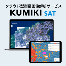
Revolutionizing inspection and investigation from space.
- Analysis and prediction system


You can easily conduct procurement simulations multiple times, allowing you to select the appropriate procurement source.
- Other Software
- Analysis and prediction system

This is a solution that uses AI specialized in the electricity business to achieve high-precision power demand forecasting.
- Other Software
- Environmental Survey
- Analysis and prediction system
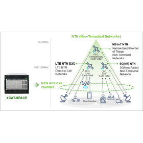

An emulator that can reproduce the wireless channel environment between the satellite and the UE in the lab!
- Analysis and prediction system

We have launched a special website!! New solutions are also featured.
Today, we have opened our special website. Until now, we have only featured measurement tools (XCAL) and analysis tools (XCAP), but starting today, we are showcasing products for the following five solutions: ◆ Local 5G Solution ◆ Network Optimization Solution ◆ NTN Measurement Solution ◆ Automotive Solution (V2X) ◆ Small Cell Solution In particular, the NTN Measurement Solution is related to the currently popular direct satellite communication solutions, and the Automotive Solution (V2X) pertains to solutions for autonomous driving, so please be sure to check it out!! If you have any questions, please feel free to contact us. Thank you very much for your continued support.
![[Digital Jellyfish Case Study] Tria...](https://image.www.ipros.com/public/product/image/6c4/2000958118/IPROS44170500257030087199.png?w=280&h=280)
Design change request to the client based on the data observed from the digital jellyfish.
- Harbor Construction
- Weather Survey

Easily obtain real-time wave heights on-site! [NETIS registration number QSK-170002-VE]
- Harbor Construction
- Coastal construction
- Weather Survey

What is the "utilization coefficient" used in port construction for those involved in marine construction?
Thank you for always watching. This time, I will talk about important indicators used in port operations. Depending on the site environment, offshore construction is easily affected by waves and wind, and it is particularly necessary to carefully consider weather conditions in cost management and labor management. For this reason, there is an important keyword in offshore construction known as "utilization coefficient." This time, we will take a rough look at this "utilization coefficient." 1. What does "utilization" mean? 2. Calculation of the utilization coefficient 3. Concept of the utilization coefficient 1. What does "utilization" mean? First, "utilization" refers to the state in which machinery and equipment have been delivered to the construction site. The number of days from when the equipment is delivered to when it is removed is called "utilization days." Additionally, the construction period (excluding preparation and cleanup) includes not only the days when work is performed (operating days) but also non-operating days (holidays, safety training days, days of inclement weather, etc.). The remaining days in a year (365 days) after excluding these non-operating days constitute the annual "operating days" for the machinery and equipment. *For more details, please visit our website or feel free to contact us.
![[Feature Introduction] Digital Jell...](https://image.www.ipros.com/public/product/image/c9a/2001488092/IPROS98225687944626931637.jpeg?w=280&h=280)
Utilize observation data as evidence for establishing unique construction standards and for work stoppages due to inclement weather!
- Weather Survey
- Coastal construction
- Harbor Construction


Strict confidentiality! Proposal for the planned management and reduction of suddenly occurring environmental costs!
- Geological Survey
- Environmental Survey

Understanding the sedimentation status of dam lakes and reservoirs in a spatial manner! Acquiring three-dimensional terrain data that can be used for maintenance management and capacity evaluation.
- Surveying
Responding to port, fishing port, and coastal area surveys in the Tohoku coastal area! High-precision multi-beam bathymetry for comprehensive understanding of seabed topography.
- Surveying
Using high-precision multi-beam sonar to comprehensively understand seabed topography for depth measurements and sediment accumulation checks in harbors and fishing ports.
- Surveying
Visualizing the seabed topography around port facilities in a planar manner! Usable for depth measurement, maintenance management, and dredging considerations.
- Surveying
Visualizing sediment accumulation and usable water depth in fishing ports in a planar manner! Three-dimensional terrain data that can be utilized for dredging studies and maintenance management.
- Surveying
Enhancing the maintenance and management of water infrastructure using three-dimensional terrain data! Supporting sediment accumulation monitoring and long-term change comparison.
- Surveying
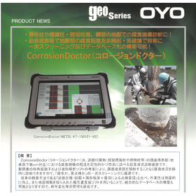

Screening investigation and corrosion site identification using non-destructive testing technology.
- Non-destructive testing
- maintenance
- Other civil engineering works
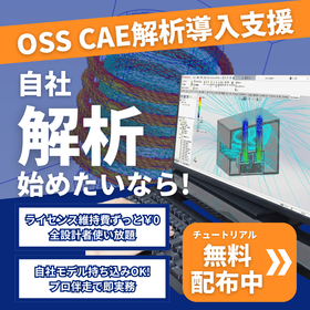

Break down the barriers of "high software costs" and "difficulty in environment setup and operation"! Our expert staff will provide support from software installation to analysis.
- Analysis and prediction system
- Architectural design office
- Specialized Construction
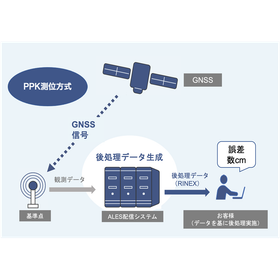
A service that provides generated correction data in file format for post-processing, based on data observed at SoftBank Corp.'s unique reference points.
- Surveying
Achieving high-precision positioning with an accuracy of a few centimeters using RTK technology.
- Surveying


The measurement accuracy is high, ranging from ±4mm to ±10mm! It is possible to measure a wide area in a short time.
- Surveying
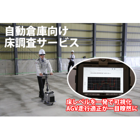
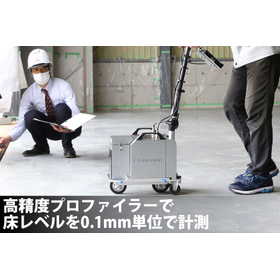
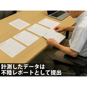
Proposal for a floor survey service that quantifies floor accuracy before the introduction of AGVs and AMRs, visualizes unevenness and defects, and leads to optimal renovation decisions.
- Surveying
- Other measuring instruments