

Supports dual-frequency GNSS and PPK positioning. A domestically produced photogrammetry drone that combines long-range communication and convenience.
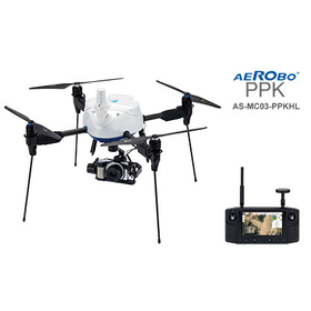
The "AeroRob PPK (AS-MC03-PPKHL)" is a domestically produced photogrammetry drone equipped with a dual-frequency GNSS receiver, supporting post-processed kinematic (PPK) positioning. By accurately calculating the camera position at the time of shooting through PPK positioning, it reduces the need for setting up and surveying reference points, thereby streamlining fieldwork in photogrammetry. It is equipped with a Sony α6100 and a 3-axis gimbal. With the adoption of Herelink HD Transmission, it allows for flying while checking the drone camera's footage on a handheld control device, and it supports taking still images from any angle. By combining it with the GNSS ground marker "AeroRob Marker" and the photogrammetry analysis and data management system "AeroRob Cloud," it can enhance the efficiency of operations from aerial photography, PPK positioning, image analysis, to deliverable creation. Additionally, it has obtained the "JC-STAR Compliance Label★1," which visualizes security measures for IoT products. This can be used as information to verify compliance with security requirements when introducing or procuring commercial drones.
Inquire About This Product
basic information
■Specifications Model: AS-MC03-PPKHL Dimensions & Weight: 517×517×509mm (without propellers) / 3.02kg Maximum Payload Capacity: 1.8kg Maximum Operating Time: 25 minutes Maximum Speed & Wind Resistance: 36km/h / 15m/s Dust and Water Resistance: IP43 (excluding camera and gimbal) Communication Method & Range: 2.4GHz / over 3km GNSS: Dual-frequency GNSS compatible (GPS/QZSS, GLONASS, Galileo, BeiDou) Mounted Camera: Sony α6100, 3-axis gimbal Control Terminal / Flight Management Software: Herelink HD Transmission / Aerobo Station *The maximum operating time is measured under controlled conditions. Actual flight time may vary depending on flight environment and usage. ■Security Compliance Information JC-STAR Compliance: ★1 (Level 1) Registration Number: 2026070300002893 Applicable Model: AS-MC03-PPKHL
Price range
Delivery Time
Applications/Examples of results
Photogrammetry for civil engineering and construction sites Three-dimensional surveying compatible with i-Construction Verification of the condition of land development and earthwork sites Understanding the situation at disaster sites and areas difficult to access Creation of orthophotos and point cloud data Recording and current condition verification from an oblique angle
Company information

We will contribute to society by bringing transformation with cutting-edge drones, AI, and cloud technology, automating various tasks in the real world.

![[Drone] New AeroBot PPK (AS-MC03-PPKHL)](https://image.www.ipros.com/public/product/image/c29/2001099510/IPROS04147789082142540405.png?w=280&h=280)

