To improve the accuracy of logging plans. Achieving positioning with an error of a few centimeters.
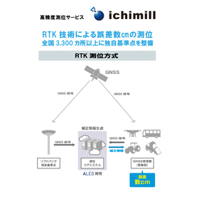
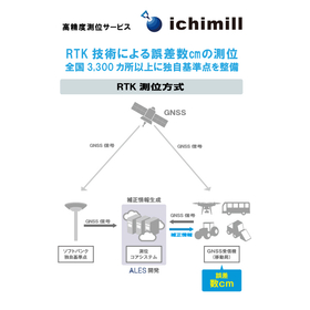
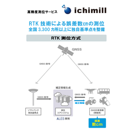
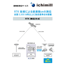
In forestry, the accuracy of logging plans directly impacts work efficiency and the effective use of resources. Particularly, accurately identifying locations and specific logging areas in vast forests is a crucial element in planning. Inaccurate positioning can lead to delays in planning and waste of resources. The high-precision positioning service "ichimill" enables positioning with an error of just a few centimeters through RTK technology, supporting the improvement of logging plan accuracy. 【Usage Scenarios】 - Identifying target trees for logging in vast forest areas - Accurate surveying of logging plan areas - Understanding the current location of workers and ensuring safety management 【Effects of Implementation】 - Improved work efficiency through enhanced accuracy of logging plans - Reduction of resource waste, contributing to sustainable forest management - Ensuring worker safety and rapid situational awareness
Inquire About This Product
basic information
【Features】 1. Establishment of SoftBank's unique reference points at over 3,300 locations nationwide SoftBank has densely established its unique reference points at over 3,300 locations across the country as fixed stations necessary for RTK positioning. This allows for easy implementation without the need for customers to set up their own reference stations. 2. Service Types We provide a correction information distribution service using the Ntrip method, allowing customers to utilize services tailored to their needs. Additionally, we offer the "Ntrip (G-VRS) Plan" for customers who wish to conduct surveys using electronic reference points. 3. Visualization with Web Management System By using the web management system (WEB-UI) provided by SoftBank, you can check the current location and movement trajectory of devices on PCs or smartphones. It can also be integrated with your system via API, enabling collaboration and utilization with various data.
Price range
Delivery Time
Applications/Examples of results
Related to autonomous vehicles, transportation, agriculture, ships, drones, construction equipment, surveying, mapping, robots, infrastructure monitoring, infrastructure inspection and maintenance, public surveying, etc.
catalog(7)
Download All Catalogs


![[Case Study] Goyo Construction Co., Ltd.](https://image.www.ipros.com/public/catalog/image/01/5ea/745767/IPROS49299094626506848488.jpeg?w=120&h=170)
Company information

Support for Corporate DX Providing the four foundations necessary for digitalization 1. Communication Improvement of the work environment / Cloud-based information / Robust network communication 2. Automation Automation of routine tasks / Creation of workforce / Productivity enhancement 3. Marketing Data collection and integration / Analysis and visualization of customer profiles / Advertising distribution and effectiveness measurement 4. Security Building secure networks / Latest malware countermeasures / Utilization of secure cloud services

![Ondroid Temperature and Humidity Measurement System [NETIS Registered]](https://image.www.ipros.com/public/product/image/e07/2000958809/IPROS5006325476243739480.jpg?w=280&h=280)
![Subsurface Displacement Meter ShapeArray CLOUD [NETIS Registered]](https://image.www.ipros.com/public/product/image/923/2000958841/IPROS67952349693334637149.jpeg?w=280&h=280)