It is a system aimed at strongly backing up rescue activities during disasters.
The general-purpose GIS "map wave" for municipalities is a support system for individuals requiring assistance during evacuation, tailored to the needs of various departments and personnel within the municipality. It can manage the maintenance of a registry of individuals needing assistance, as well as the monitoring system involving community welfare commissioners and local volunteers, in conjunction with the geographic information system. Additionally, it provides comprehensive support for the individual formulation of evacuation plans and for confirming the safety of individuals during disasters. 【Features】 ■ Integration with the Basic Resident Registration System ■ Diverse search and display functions using the map system ■ Simulation for planning evacuation strategies *For more details, please download the PDF or contact us.

Inquire About This Product
basic information
For more details, please download the PDF or contact us.
Price range
Delivery Time
Applications/Examples of results
For more details, please download the PDF or contact us.
catalog(1)
Download All Catalogs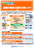
Company information

Our company promotes the strategic use of information data and conducts business that accelerates our customers' operations through the power of IT systems. With the mission of "Shaping Information," we aim to contribute to our customers and society by realizing "visualization of the market" through big data. Please feel free to contact us if you have any inquiries.


![Portable GIS System "Ki-Navi" [for Forest Measurement]](https://image.www.ipros.com/public/product/image/aa6/2000490928/IPROS79787169387941713586.png?w=280&h=280)


