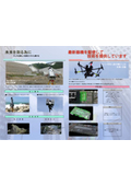
Safe and speedy filming is possible! For gathering information at disaster sites and understanding construction progress.
Our company has made it possible to use UAVs (unmanned aerial vehicles) to safely and quickly capture high-quality videos and photos in areas that were previously difficult for humans to access. This is particularly effective for gathering information at disaster sites, monitoring construction progress, inspecting structures such as bridges and dams, and conducting cultural heritage surveys. By obtaining three-dimensional terrain data with UAVs, we can minimize on-site survey time and efficiently conduct surveys such as topographic surveys, longitudinal surveys, and cross-sectional surveys. Even for high-altitude inspections, there is no need for scaffolding or high-altitude workers. By using UAVs equipped with obstacle detection systems, we can perform inspection work safely and economically. 【Features】 ■ Minimizes on-site survey time ■ Capable of capturing high-quality videos and photos ■ No need for scaffolding or high-altitude workers for high-altitude inspections ■ Allows for accurate situation assessment and life detection from a distance *For more details, please refer to the PDF document or feel free to contact us.
Inquire About This Product
basic information
【Workflow】 ■Flight Plan: Obtain location information using GPS/GNSS data from satellites to conduct measurements with the autonomous navigation system. ■Photo Mapping: Confirm that the flight and photography are conducted as set by the autonomous navigation system. ■Point Cloud and Mesh Model Creation: Utilize the creation of a three-dimensional model for volume calculations, topographic maps, cross-sectional diagrams, and design model creation. 【Equipment Owned】 ■SPIDER (manufactured by LUCESARCH) ・Flight Time: 10 to 25 minutes (lithium polymer battery) ・Payload: 4,000g to 6,000g (varies by aircraft) ・Capture Range: Approximately 1,000m ・Maximum Altitude: 250m ■Phantom4 (manufactured by DJI) ・Flight Time: 28 minutes ・Operational Ceiling (above sea level): 6000m ・Maximum Wind Resistance: 10m/s ・Operating Temperature: 0 to 40°C *For more details, please refer to the PDF document or feel free to contact us.
Price range
Delivery Time
Applications/Examples of results
【Uses】 ■ Aerial photogrammetry ■ Inspection of structures ■ Aerial photography and videography ■ Disaster investigation *For more details, please refer to the PDF document or feel free to contact us.
catalog(3)
Download All CatalogsCompany information
The former company name of Sanki, "Sanki," means planning the three departments of surveying, design, and registration to be of service to society. Moving forward, we are further uniting as one with the addition of the three energies: vitality, ambition, and motivation. Sanki is a future-oriented company (not just better) where both the company improves from today to tomorrow and individuals elevate themselves, creating a vibrant atmosphere. Young employees each have their own life goals and are dedicated to enhancing their skills. Above all, the best aspect is the freedom to express one's thoughts and the ability to work with responsibility. The foundation of Sanki's actions and philosophy is to cherish the spirit of "Thank you always, dear customers." We are a group of skilled professionals who transform gratitude into hospitality, striving for harmony between the individual and the whole, and continuing to develop further.


![[Free Gift] Katamiya Industry Service Guide and Case Studies](https://image.www.ipros.com/public/product/image/9be/2000152312/IPROS561938291760501164.JPG?w=280&h=280)


![[Rental] New Panaguide + AI Automatic Translation Device Simultaneous Interpretation System](https://image.www.ipros.com/public/product/image/254366/IPROS11212851514804492938.jpg?w=280&h=280)
![[Rental] VX-D2901U Vehicle-mounted Digital Simple Radio Registered Station](https://image.www.ipros.com/public/product/image/254366/IPROS2245405174508058432.jpg?w=280&h=280)
![[Rental] FTR-410D | Specific Low Power Transceiver Repeater](https://image.www.ipros.com/public/product/image/254366/IPROS18040955508108055620.jpg?w=280&h=280)