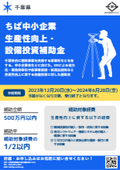
Kanagawa Prefecture: Subsidy Information - Subsidy for the Promotion of Productivity Improvement in Small and Medium-sized Enterprises for Fiscal Year 2024
<Eligible Recipients>
Small and medium-sized enterprises as defined in Article 2, Paragraph 1 of the "Small and Medium-sized Enterprise Support Act (Law No. 147 of 1963)" that have a business office in Kanagawa Prefecture.
<Eligible Expenses>
- Machinery and equipment costs, IT service implementation costs, facility construction costs
<Subsidy Limit and Rate>
5 million yen (rounded down to the nearest thousand) / up to 1/2
<Application Acceptance Period>
August Deadline: August 1, 2024 (Wednesday) 9:00 AM to August 30, 2024 (Friday) 5:00 PM
September Deadline: September 2, 2024 (Monday) 9:00 AM to September 30, 2024 (Monday) 5:00 PM
For inquiries about introducing cutting-edge equipment using subsidies, please feel free to contact Yokohama Sokkiki!

Inquiry about this news
Contact Us Online
Related Documents
Related product


Related catalog(22)

![[Attention Kanagawa Prefecture Businesses!] Subsidy for the Promotion of Productivity Improvement for Small and Medium Enterprises in Fiscal Year 2024](https://image.www.ipros.com/public/catalog/image/01/3b5/750199/IPROS62197564750867279215.jpeg?w=120&h=170)


![[Subsidy-eligible product] PENTAX Z+F IMAGER5016 Laser Scanner](https://image.www.ipros.com/public/catalog/image/01/2e7/606864/IPROS52783956900246676094.jpeg?w=120&h=170)
![[Subsidy-eligible product] 'Leica RTC360' 3D reality capture solution](https://image.www.ipros.com/public/catalog/image/01/48f/507038/IPROS62747457392826736115.jpeg?w=120&h=170)
![[Subsidy-eligible products] 3D and 2D laser scanners 'PENTAX S Series'](https://image.www.ipros.com/public/catalog/image/01/ac3/446243/IPROS19093341542938425025.jpeg?w=120&h=170)
![[Subsidy-eligible product] Laser scanner 'Leica ScanStation P50'](https://image.www.ipros.com/public/catalog/image/01/cae/426979/IPROS27342789044026833293.jpeg?w=120&h=170)

![UAV Laser Surveying System UL-1 [Discontinued]](https://image.www.ipros.com/public/catalog/image/01/a34/507039/IPROS31283546511752388759.jpeg?w=120&h=170)
![[Subsidy-eligible product] NORBIT-WINGHEAD Ultra High-Resolution Narrow Multi-Beam Sonar](https://image.www.ipros.com/public/catalog/image/01/ca9/615899/IPROS58552909415493052088.jpeg?w=120&h=170)

![[Subsidy-eligible product] GNSS survey instrument 'Leica GS18I'](https://image.www.ipros.com/public/catalog/image/01/1be/549987/IPROS27679954776591843026.jpeg?w=120&h=170)

![[Eligible for IT Introduction Subsidy!] Large-scale Point Cloud Editing Tool 'Wing Earth' Materials](https://image.www.ipros.com/public/catalog/image/01/80a/515324/IPROS44919236532072656878.jpeg?w=120&h=170)


Distributors


