1~2 item / All 2 items
Displayed results

Added to bookmarks
Bookmarks listBookmark has been removed
Bookmarks listYou can't add any more bookmarks
By registering as a member, you can increase the number of bookmarks you can save and organize them with labels.
Free membership registrationContact this company
Contact Us OnlineBefore making an inquiry
Download PDF1~2 item / All 2 items

We offer a construction industry-specific AR app called 'TerraceAR' that allows you to easily experience AR on your iPhone or iPad. You can place original 3D data created on-site as AR content. The app is equipped with features that are convenient for work on construction sites. Additionally, we provide a dump load and snow removal measurement app called "NorthCan," which utilizes LiDAR, and we also leverage AI and IoT technologies. 【Features】 ■ Easily place and check 3D models even when the actual object is not on-site ■ Simple measurements can be taken on-site ■ Guides for confirming the completed work can be displayed ■ 3D models can be placed according to local coordinates ■ Our unique Terrace tool clearly displays invisible parts such as underground or underwater *For more details, please download the PDF or feel free to contact us.
Added to bookmarks
Bookmarks listBookmark has been removed
Bookmarks listYou can't add any more bookmarks
By registering as a member, you can increase the number of bookmarks you can save and organize them with labels.
Free membership registration
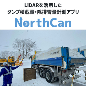
"NorthCan" is an app that dramatically improves the efficiency of measurement tasks at construction sites. By utilizing the LiDAR sensors on iPhones and iPads, it can quickly and accurately measure the load capacity of dump trucks. It can be used in a wide range of scenarios, including snow removal and earth transportation. 【Features】 ■ By placing markers in the measurement area, the measured point cloud data is automatically trimmed, streamlining the adjustment of the measurement range. ■ The eraser tool allows for editing the mesh, enabling the deletion of unnecessary measurement points. ■ By converting the measured point cloud data into voxels, it calculates the volume. ■ By leveraging the LiDAR built into iPhones/iPads, the entire process from measurement to analysis can be completed on-site. *For more details, please download the PDF or feel free to contact us.
Added to bookmarks
Bookmarks listBookmark has been removed
Bookmarks listYou can't add any more bookmarks
By registering as a member, you can increase the number of bookmarks you can save and organize them with labels.
Free membership registration