Scanner Product List and Ranking from 178 Manufacturers, Suppliers and Companies | IPROS

Last Updated: Aggregation Period:May 06, 2026~Jun 02, 2026
This ranking is based on the number of page views on our site.

Scanner Manufacturer, Suppliers and Company Rankings

Last Updated: Aggregation Period:May 06, 2026~Jun 02, 2026
This ranking is based on the number of page views on our site.

  1. あれとこれ Saitama//Service Industry
  2. null/null
  3. 横浜測器 本社 Kanagawa//Trading company/Wholesale
  4. 4 ユニテック・ジャパン Tokyo//Trading company/Wholesale
  5. 5 トプコン Tokyo//others

Scanner Product ranking

Last Updated: Aggregation Period:May 06, 2026~Jun 02, 2026
This ranking is based on the number of page views on our site.

  1. Restore drawings with 3D scanning too! First-time service campaign ongoing! あれとこれ
  2. 3D Laser Scanner "GLS-2200 Series" トプコン
  3. 3D laser scanner 'BLK360 G2' acquires data in 20 seconds!
  4. 4 FJD SLAM Scanner Trion P2 山陽測器
  5. 5 High-speed, high-precision 3D laser scanner 'Leica RTC360'

Scanner Product List

541~570 item / All 720 items

Displayed results

Wireless 2D Pocket Scanner "MS926P"

Quickly and easily connect to devices without complicated settings! Adopts durable and easy-to-pair wireless technology.

The MS926P is a wireless 2D pocket scanner that features a highly efficient decoder built into a pocket-sized body. It has a 1-inch OLED display and a lightweight, portable design. You can simply scan 1D or 2D barcodes and check the feedback of the scanned information in real-time. It is also equipped with a vibration mode for confirming readings, providing more flexibility when you don't want to make noise in a hospital setting. 【Features】 ■ Easy to operate due to its pocket-sized design ■ Simple pairing with the included USB dongle ■ Date/time stamp records the date and time of scanned items ■ Durable for business use: 1.5m drop resistance and IP42 dust and water resistance ■ Long operating time of up to 9 hours after a full battery charge *For more details, please refer to the PDF document or feel free to contact us.

  • Handheld terminal
  • Scanner

Added to bookmarks

Bookmarks list

Bookmark has been removed

Bookmarks list

You can't add any more bookmarks

By registering as a member, you can increase the number of bookmarks you can save and organize them with labels.

Free membership registration

High Durability Area Imager "Voyager XP 1470g"

Top-class scanning performance and durability! Wired and wireless models available.

The "Voyager XP 1470g" is a wired model high-durability 2D scanner designed for retail stores and light-duty tasks. It is lightweight and easy to handle, and with the new compact engine, it can read barcodes from all directions, 360°, without worrying about the orientation of the barcode. It can be introduced at a low cost and is capable of reading barcodes without height and damaged barcodes, as well as barcodes and QR codes displayed on LCD screens of smartphones and other devices. Additionally, a wireless model, the "Voyager XP 1472g," is also available. 【Features】 ■ Drop resistance: 1.8m ■ Accurately reads low-quality barcodes ■ The wired model comes with a 5-year warranty, while the wireless model has a 3-year warranty ■ The wireless model has a communication range of 10m *For more details, please refer to the PDF document or feel free to contact us.

  • Handheld terminal
  • Scanner

Added to bookmarks

Bookmarks list

Bookmark has been removed

Bookmarks list

You can't add any more bookmarks

By registering as a member, you can increase the number of bookmarks you can save and organize them with labels.

Free membership registration

3D Laser Measurement Business 3D Laser Measurement

Can be read as 3D data! Dimension measurement and shape recognition are possible.

Our company conducts "3D laser measurement." 3D laser scanning involves using a 3D laser scanner to read the target object as point cloud data and obtain three-dimensional coordinates. Since it can read data in three dimensions, it allows for dimension measurement and shape recognition. 【How 3D Laser Scanners Work】 - The distance is calculated based on the waveform reflected from the target object when the laser is directed at it (the X, Y, and Z coordinates of the point are calculated from the angle of the scanner). - The measurement range is 150m, and the measurement accuracy is ±1.0mm at a distance of 10m. *The catalog can be downloaded from the related link.

  • Drawing, tracing, CAD
  • Scanner

Added to bookmarks

Bookmarks list

Bookmark has been removed

Bookmarks list

You can't add any more bookmarks

By registering as a member, you can increase the number of bookmarks you can save and organize them with labels.

Free membership registration

3D Laser Measurement Business: Examples of 3D Laser Measurement

We will collect point cloud data of the target object using a 3D laser scanner!

We would like to introduce examples of 3D laser measurement conducted by our company. We will explain examples such as the Terufaru Crane, the National Treasure designated Kunozan Toshogu Shrine, and bridges that have been photographed. The collected data is analyzed, modeled, and edited using the point cloud processing software "Galaxy-Eye" (manufactured by Fuji Technical Research Co., Ltd.), allowing us to provide deliverables at each stage of the process. [Examples] ■ Measurement and photography of the Terufaru Crane (registered tangible cultural property, mechanical heritage, Shimizu Port) using a 3D scanner ■ Measurement of bridges using a 3D scanner ■ Kunozan Toshogu Shrine, designated as a National Treasure *The catalog can be downloaded from the related link.

  • Drawing, tracing, CAD
  • Scanner

Added to bookmarks

Bookmarks list

Bookmark has been removed

Bookmarks list

You can't add any more bookmarks

By registering as a member, you can increase the number of bookmarks you can save and organize them with labels.

Free membership registration

Coordinate Transformation Utility "LandStation-CZ"

Fast batch conversion of coordinates with easy operation!

- Convert coordinates from "Cartesian coordinate system" to "latitude and longitude." Convert coordinates from "latitude and longitude" to "Cartesian coordinate system." - Coordinates can be bulk imported from "text files (CSV/TXT format)" and "SIMA format" files. - Converted coordinates can be transformed into various file formats! (CSV, TXT, SIMA, KML, Geospatial Agency maps, PC-Mapping)

  • Measurement and analysis equipment leasing and rental
  • Surveying
  • Scanner

Added to bookmarks

Bookmarks list

Bookmark has been removed

Bookmarks list

You can't add any more bookmarks

By registering as a member, you can increase the number of bookmarks you can save and organize them with labels.

Free membership registration

3D handheld scanner 'Artec Leo'

High-mobility 3D scanner! It dramatically improves the processes of packaging manufacturers.

The "Artec Leo" is a 3D scanner that automatically scans using an internal program. It is an all-in-one device with built-in PC functionality and battery, simplifying complex workflows into easy-to-follow procedures, allowing 3D scanning to be performed as effortlessly as recording a video. While scanning an object, you can view the 3D model being measured in real-time on the touch panel screen. 【Features】 ■ Mobile 3D scanner ■ Smart 3D scanner ■ User-friendly design ■ Capable of scanning black and shiny objects ■ Advanced 3D software *For more details, please refer to the PDF document or feel free to contact us.

Added to bookmarks

Bookmarks list

Bookmark has been removed

Bookmarks list

You can't add any more bookmarks

By registering as a member, you can increase the number of bookmarks you can save and organize them with labels.

Free membership registration

High-precision fixed scanner FARO Focus premium MAX

Ultra-high precision fixed laser scanner

The FARO Focus Premium MAX, a fixed laser scanner, can acquire high-precision, high-resolution three-dimensional point clouds over a wide area in a short measurement time. It is the ideal measuring device for obtaining high-precision point clouds in millimeter units. Since it can perform matching of multiple measurements using the surrounding shapes without target markers, there is no need for the cumbersome installation of target markers. By using high-precision three-dimensional point clouds, it is possible to obtain data on the dimensions of various parts of large facilities such as factories and the current arrangement of equipment. Therefore, using this technology allows for the creation of foundational documents for facility renovation plans and the development of facility plans after relocation. Traditionally, it was necessary to measure each area manually, but the Focus series can convert everything into point clouds at once, eliminating that need. Operations during measurement can be conducted via the smartphone application "FARO Stream." This app is common with Orbis.

  • Construction company
  • Scanner

Added to bookmarks

Bookmarks list

Bookmark has been removed

Bookmarks list

You can't add any more bookmarks

By registering as a member, you can increase the number of bookmarks you can save and organize them with labels.

Free membership registration

Information about Ito Co., Ltd.'s "CIM/i-con Support Tool"

Introducing tools for acquiring and editing large-scale point cloud data!

At Ito Corporation, we mainly handle the 'CIM・i-con Support Tool' for civil engineering surveying. We offer a wide range of large-scale point cloud data acquisition tools such as "senseFly albris" and "Trimble UX5," as well as point cloud utilization 3D CAD software like "AutoCAD Civil 3D" and "V-nasClair." Please feel free to contact us if you have any inquiries. 【Product Lineup】 ■ UAS/UAV ■ Laser Scanners ■ SFM software for deriving point clouds from photos ■ Point cloud processing software ■ 3D CAD related (LandXML), etc. *For more details, please download the PDF or feel free to contact us.

  • Drawing, tracing, CAD
  • Surveying
  • Scanner

Added to bookmarks

Bookmarks list

Bookmark has been removed

Bookmarks list

You can't add any more bookmarks

By registering as a member, you can increase the number of bookmarks you can save and organize them with labels.

Free membership registration

Drone & Laser Scanner High-Precision 3D Mapping

Drones from the sky and laser scanners from the ground can grasp the terrain before construction! A measurement service utilizing ICT.

Measurements will be taken using UAVs (drones) from the air and LS (laser scanners) from the ground. The drone-mounted laser scanner enables "high-precision 3D mapping," which was not achievable with conventional photogrammetry. This allows for extensive measurements in a short time, enabling an understanding of the terrain before construction and facilitating the early planning of construction projects. 【Features】 - Regular aerial photography of construction progress and construction photos. - Automated navigation using GPS and other aids to fly along predetermined routes for terrain measurement and earth volume management. - The combined use of drone-mounted laser scanners and ground-based 3D scanners allows for high-precision measurement of terrain and structures by emitting laser (light). *For more details, please contact us or download the PDF for more information.

  • Distance measuring device/length measuring device
  • Consulting companies
  • Surveying Office
  • Scanner

Added to bookmarks

Bookmarks list

Bookmark has been removed

Bookmarks list

You can't add any more bookmarks

By registering as a member, you can increase the number of bookmarks you can save and organize them with labels.

Free membership registration

3D Texture Scanner "SURF 3D"

A 3D scanner that can capture not only surface colors and text information but also texture data! Its compact size fits on a desk and makes it easy to carry!

"SURF 3D" is a 3D texture scanner from the Italian company METIS that we handle. It can scan surface texture and grain information along with the color information of images. The device is compact enough to fit on a desk and can accommodate originals up to a maximum size of 52cm x 32cm. For larger originals, it is equipped with a function to perform image data stitching after splitting the input. 【Features】 ■ Capable of scanning surface texture and grain information ■ Compact size that fits on a desk ■ Supports originals up to a maximum size of 52cm x 32cm ■ For larger originals, it has a function to perform image data stitching after splitting the input *For more details, please request a brochure or view the PDF data available for download.

  • others
  • Scanner

Added to bookmarks

Bookmarks list

Bookmark has been removed

Bookmarks list

You can't add any more bookmarks

By registering as a member, you can increase the number of bookmarks you can save and organize them with labels.

Free membership registration

2.5D Scanner "METIS DRS2000DCS"

Capable of scanning color and text information along with texture information! 2.5D large scanner for building materials and artworks.

The "METIS DRS2000DCS" is a large 2.5D scanner that can scan not only colors and text information but also very fine details with precision. By using the patented DC Synchrono Light source system and controlling it with proprietary software called Scan Director, it is possible to create thousands of different lighting conditions with just a few scans. It can capture not only the colors of the original document but also the surface reflections, such as glossiness in wood grain documents, and even three-dimensional shapes, allowing for the complete input of the information contained in the original. 【Features】 ■ Simultaneous acquisition of texture color information and surface relief information ■ Utilizes the patented DC Synchrono Light source system ■ Captures thousands of lighting information in a single scan ■ Ideal for scanning wood grain, leather texture, and oil painting expressions ■ Resolution: 300 PPI to 1000 DPI *For more details, please refer to the PDF materials or feel free to contact us.

  • others
  • Scanner

Added to bookmarks

Bookmarks list

Bookmark has been removed

Bookmarks list

You can't add any more bookmarks

By registering as a member, you can increase the number of bookmarks you can save and organize them with labels.

Free membership registration

[Technical Document] About the Appearance Inspection of Tank Side Plates Using 3D Measurement Scanners

Enabling measurements on-site with a 3D scanner, a battery, and an analysis computer as a three-piece set!

This document introduces technical information about the visual inspection of tank side plates using a 3D measurement scanner. It provides detailed explanations of the "measurement system" and "target inspection tank" using photographs. The method using a depth gauge has some difficulties in measuring accuracy and understanding the history of corrosion progression. Therefore, we conducted measurements using a 3D scanner, which we would like to introduce. Please take a moment to read it. 【Contents (excerpt)】 ■ Introduction ■ Measurement System ■ Target Inspection Tank ■ Inspection Results ■ Verification *For more details, please refer to the PDF document or feel free to contact us.

  • Other measuring instruments
  • Scanner

Added to bookmarks

Bookmarks list

Bookmark has been removed

Bookmarks list

You can't add any more bookmarks

By registering as a member, you can increase the number of bookmarks you can save and organize them with labels.

Free membership registration

Laser scanner "S-3180V"

It starts up in about 30 seconds after turning on the power switch! It complies with laser class 1, ensuring high safety.

We would like to introduce the 'S-3180V' handled by KSK Corporation. The 'S-3180V' is a ground-based 3D laser scanner that supports HDR color images with a clear and wide dynamic range, as well as a variety of flexible scanning methods. It is equipped with a measurement range tailored to the object and environment, allowing for efficient acquisition of three-dimensional coordinate data on-site. 【Features】 <S-3180V> ■ High-speed scanning: 1,016,027 points/second ■ Maximum measurement range: 187m ■ Full-color point cloud data like photographs ■ High-resolution color display ■ Quick trajectory *For more details, please refer to the PDF document or feel free to contact us.

Added to bookmarks

Bookmarks list

Bookmark has been removed

Bookmarks list

You can't add any more bookmarks

By registering as a member, you can increase the number of bookmarks you can save and organize them with labels.

Free membership registration

Z+F manufactured 3D laser scanner 'IMAGER 5016'

3D laser scanning of complex and large-scale equipment at ultra-high speed, ultra-high resolution, and ultra-high precision! It can also measure black objects and shiny metal pipes!

The "IMAGER 5016" scans complex and large-scale equipment at ultra-high speed, ultra-high resolution, and ultra-high precision, allowing for the synthesis of multiple scan data without the use of targets, and enabling automatic data processing during scanning downtime. It comes standard with a built-in HDR camera that allows for white balance adjustment and an LED light that enables color photography even at night. Additionally, it enables automatic synthesis without the need for target placement, achieving further compactness and lightweight design. 【Features】 ■ Lightweight, compact, and highly operable design ■ Maximizes measurement range and speeds up measurement time (approximately 3 minutes) using a phase difference method ■ Incredible accuracy and low range noise that competitors cannot match ■ Targetless synthesis and real-time data transfer/data processing improve work efficiency *For more details, please request materials or view the PDF data available for download.

  • Other analytical equipment
  • Scanner

Added to bookmarks

Bookmarks list

Bookmark has been removed

Bookmarks list

You can't add any more bookmarks

By registering as a member, you can increase the number of bookmarks you can save and organize them with labels.

Free membership registration

Laser Scanner Leica BLK360 [Rental] [Sale]

The Leica BLK360 is the world's smallest and lightest imaging scanner that can be easily operated with the push of a button.

■Easy Operation Simply press the button on the main unit to start scanning immediately. It is designed to be user-friendly for anyone. ■Portable The BLK360 is the world's smallest and lightest scanning system. It weighs only 1 kg, making it easy to carry to any site. ■High Productivity It can acquire HDR images, thermal images, and point cloud data, and stream to iPad Pro in about 3 minutes. ■Outstanding Features of BLK360 - HDR Imaging: 3-camera 15MP system / Equipped with LED flash - Thermal Imaging: Standard thermal camera included - Scanning: Maximum measurable distance of 60m / 360,000 points per second using Class 1 invisible laser - Other Features No cable connection required Battery capable of approximately 40 scans Internal memory can store over 100 scans

  • Surveying
  • Structural Survey
  • Scanner

Added to bookmarks

Bookmarks list

Bookmark has been removed

Bookmarks list

You can't add any more bookmarks

By registering as a member, you can increase the number of bookmarks you can save and organize them with labels.

Free membership registration

Leica RTC360 3D [Rental] [Sale]

A portable, intuitively operable, high-speed 3D laser scanner equipped with a spherical camera, designed with high productivity in mind.

■Speedy Achieves 3D reality capture at an unprecedented speed. Equipped with a measurement speed of up to 2 million points per second and an advanced HDR imaging system, color 3D point cloud data can be obtained in 2 minutes (at a scan density of 6mm@10m). ■Productivity Improvement The automatic registration feature that does not require targets, enabled by VIS technology, and the seamless automatic data transfer function from the field to the office significantly reduce field measurement time and greatly enhance productivity. ■Portable Lightweight and compact, with a portable design, the foldable dedicated tripod can be stored in a backpack. It can be taken anywhere. ■High Precision Reduces noise data to generate clearer and higher quality scan data. The high-density detail data can be used for a wide variety of applications. When combined with the Cyclone FIELD 360 software, which performs automatic synthesis processing on-site, high-precision data can be immediately verified in the field. ■Easy Operation Scanning can be done quickly and easily with a simple one-button operation.

  • Surveying
  • Scanner

Added to bookmarks

Bookmarks list

Bookmark has been removed

Bookmarks list

You can't add any more bookmarks

By registering as a member, you can increase the number of bookmarks you can save and organize them with labels.

Free membership registration

Measurement Instrument Rental

We offer rentals of 3D laser scanning systems, GPS, and more!

Kobe Seiko Co., Ltd. is a company that engages in the sale, rental, and repair of surveying, measuring, and measurement instruments, total stations, 3D laser scanners, CAD, GIS, and UAVs (drones). Our company offers rentals of total stations, levels, theodolites, 3D laser scanning systems, GPS, and more from brands such as Sokkia and Leica. You can easily conduct surveys with calibrated equipment for the necessary duration when needed. 【Rental Products】 ■ 3D Laser Scanners ■ Optical Distance Meters (Total Stations) ■ Standard Surveying Instruments (Theodolites, Levels, etc.) ■ Special Surveying Instruments ■ Laser Surveying Instruments ■ Testing Equipment and Environmental Equipment ■ Gas Detectors ■ Others (Optional Items, etc.) *As a general rule, only the models listed in the table are available for rental. *For more details, please refer to the PDF materials or feel free to contact us.

  • Other measuring instruments
  • Measurement and analysis equipment leasing and rental
  • Scanner

Added to bookmarks

Bookmarks list

Bookmark has been removed

Bookmarks list

You can't add any more bookmarks

By registering as a member, you can increase the number of bookmarks you can save and organize them with labels.

Free membership registration

How to Smartly Purchase Surveying Equipment Using Subsidies?

If you want to introduce measuring equipment but are concerned about the price... This is a must-see! We will introduce methods and examples for introducing measuring equipment using subsidies.

This document explains "How to Purchase Surveying Equipment Effectively Using Subsidies." 【Recommended for those who:】 ◎ Cannot prepare funds for expensive equipment installation ◎ Want to apply for subsidies but do not know how ◎ Cannot secure the time needed to prepare the application ◎ Want to leave the application writing to a professional with a high success rate ◎ Are looking for an expert who can handle tasks after approval as well 【Table of Contents *Partial*】 - Price Range of 3D Laser Scanners (Applicable for Subsidy Program) - What are the Funding Methods? (With Reference Examples) - About the Application Process "Yokohama Measuring Instruments" is a specialized trading company for surveying equipment, providing support from equipment proposals to after-sales follow-up. Furthermore, in collaboration with a "Ministry of Economy, Trade and Industry certified management innovation support organization familiar with subsidies," we offer comprehensive support for tasks related to subsidy applications based on the expertise of specialized consulting familiar with subsidy applications. *For more details, please refer to the catalog or PDF materials, or feel free to contact us.*

  • Development permit application
  • Scanner

Added to bookmarks

Bookmarks list

Bookmark has been removed

Bookmarks list

You can't add any more bookmarks

By registering as a member, you can increase the number of bookmarks you can save and organize them with labels.

Free membership registration

Leica Geosystems' 3D Laser Scanner 'BLK360'

Lightweight and compact for easy portability! High-speed scanning of up to 360,000 points per second with simple operation.

The BLK360 is a 3D laser scanner manufactured by Leica Geosystems that allows you to start scanning immediately by simply pressing a button on the device. Weighing just 1 kg, it is very lightweight and compact, making it easy to transport to job sites. With a scanning speed of up to 360,000 points per second, it can measure distances of up to 60 meters. The acquisition of HDR images, thermal images, and point cloud data, as well as streaming to an iPad Pro, is completed in just 3 minutes, significantly improving the efficiency of measurement tasks. For more details, please refer to the product catalog. 【Features】 - Lightweight, compact, and affordable 3D laser scanner - Easy operation with just a button press - Standard thermal camera included. Uses Class 1 invisible laser ★ We provide comprehensive support for the application process for manufacturing subsidies in collaboration with specialized consultants. Please feel free to contact us for more details. ★ Our company offers a variety of surveying instruments and systems, allowing us to make proposals tailored to your needs. For examples of products we handle, please refer to the basic information section.

  • Surveying
  • Other measuring instruments
  • Scanner

Added to bookmarks

Bookmarks list

Bookmark has been removed

Bookmarks list

You can't add any more bookmarks

By registering as a member, you can increase the number of bookmarks you can save and organize them with labels.

Free membership registration

Leica ScanStation P30/40

Introducing a 3D laser scanner that operates in harsh temperature environments from -20℃ to +50℃!

The "Leica ScanStation P30/40" is an ideal laser scanner that ensures accurate measurement time, measurement range, precision, and durability while reliably capturing details. It has a maximum measurement distance of 270 meters and generates high-quality 3D data and HDR images at a speed of 1 million points per second. With excellent measurement range and angular accuracy, as well as low range noise and two-axis compensation suitable for surveying, it produces high-quality, realistic 3D color point cloud data. 【Features】 ■ Reliable detail measurement ■ The right choice ■ High performance even in harsh environments ■ Reduced downtime ■ Total scanning system *For more details, please refer to the PDF document or feel free to contact us.

  • Other measuring instruments
  • Scanner

Added to bookmarks

Bookmarks list

Bookmark has been removed

Bookmarks list

You can't add any more bookmarks

By registering as a member, you can increase the number of bookmarks you can save and organize them with labels.

Free membership registration

[Subsidy-eligible product] Laser scanner Leica RTC360

Speedy, portable, and high precision! Equipped with seamless automatic data transfer functionality from the field to the office.

The "Leica RTC360 Laser Scanner" features a measurement speed of up to 2 million points per second and an advanced HDR imaging system, allowing for the acquisition of color 3D point cloud data in just 2 minutes. With its target-free automatic registration function powered by VIS technology and seamless automatic data transfer from the field to the office, it significantly reduces field measurement time and greatly enhances productivity. 【Features】 ■ Achieves 3D reality capture in a short time ■ Portable design and foldable dedicated tripod can be stored in a backpack ■ Can be carried anywhere ■ Simply go to the site and perform a quick and easy scan with a single button operation ★ This product qualifies as surveying equipment eligible for "subsidy utilization" upon purchase. It may be available for purchase at 1/2 to 1/3 of the regular price! If you are interested, please feel free to contact us. * For more details, please refer to the PDF materials or feel free to reach out to us.

  • Other measuring instruments
  • Scanner

Added to bookmarks

Bookmarks list

Bookmark has been removed

Bookmarks list

You can't add any more bookmarks

By registering as a member, you can increase the number of bookmarks you can save and organize them with labels.

Free membership registration

Introduction to the TLS (Terrestrial Laser Scanner) Product Lineup

Accessory options are also available! We offer products like the "RTC360," which can perform targetless point cloud synthesis.

We would like to introduce the 'TLS (Terrestrial Laser Scanner)' that we handle. Our lineup includes high-end models such as Leica's "Scan Station P Series" and PENTAX's "S-3180V," as well as the "RTC360," which allows for targetless point cloud synthesis, and the market's smallest and lightweight "BLK360." We also offer accessory options, so please use them according to your needs. 【Lineup】 ■Scan Station P Series ■RTC360 ■BLK360 ■Multi Station MS60 ■Z+F IMAGER5016 ■PENTAX S Series *For more details, please refer to the catalog or PDF materials, or feel free to contact us.

  • 2-2.png
  • 2-3.png
  • 2-4.png
  • 2-5.png
  • 25f5a4a954f507b021e194ccffec11ea.jpg
  • 3d_laser_scanner_02_822d8f8fca-300x362.jpg
  • Scanner
  • Other measuring instruments
  • Scanner

Added to bookmarks

Bookmarks list

Bookmark has been removed

Bookmarks list

You can't add any more bookmarks

By registering as a member, you can increase the number of bookmarks you can save and organize them with labels.

Free membership registration

Latest Case Studies of Point Clouds

Introducing point cloud data obtained from a laser scanner that measures various objects with excellent productivity, versatility, and operability!

Introducing point cloud data obtained from the latest laser scanner product lineup provided by Yokohama Measuring Instruments Co., Ltd.! The selection of the appropriate model is crucial depending on the intended use of the laser scanner. We offer the most suitable laser scanner for our customers from a wide range of models. The point cloud data acquired by leveraging the characteristics and features of each model has the potential to significantly impact our customers' future business development. 【Point Cloud Data by Characteristics】 ■ UAV Laser Scanner Point Cloud Data ■ Long-range Ground Laser Scanner Point Cloud Data ■ Mid-range Ground Laser Scanner Point Cloud Data ■ Compact and Lightweight Ground Laser Scanner Point Cloud Data *For more details, please refer to the catalog or PDF materials, or feel free to contact us.

  • 2.jpeg
  • 3.png
  • 4.png
  • 5.png
  • 6.png
  • Surveying
  • Other measuring instruments
  • Scanner

Added to bookmarks

Bookmarks list

Bookmark has been removed

Bookmarks list

You can't add any more bookmarks

By registering as a member, you can increase the number of bookmarks you can save and organize them with labels.

Free membership registration

Acquisition of realistic point cloud data is possible with Z+F IMAGER 5016.

[Subsidy-eligible products] Achieve 3D modeling at low cost with ultra-fast and ultra-high precision scanning! Providing new solutions that were previously difficult to realize!

The "PENTAX Z+F IMAGER 5016 Laser Scanner" achieves a compact and lightweight design while incorporating advanced HDR camera capabilities, built-in navigation system, and high-speed Wi-Fi functionality without compromising on the advantages of high precision, high scan rate, and low range noise provided by the phase difference method! It comes standard with an LED light for color photography in dark environments (capable of illuminating up to 10m). Equipped with high-speed Wi-Fi, it enables real-time high-speed data transfer of measurement data to a Tablet PC using the included IMAGER5016 dedicated software "LC SCOUT"! It allows for simultaneous verification of 3D point cloud data during measurement, significantly improving productivity. 【Features】 ■ Achieves 3D reality capture in a short time ■ Portable design that can be stored in a backpack *For more details, please refer to the PDF document or feel free to contact us. ★ This product is a surveying instrument eligible for "subsidy utilization" upon purchase. It may be available for purchase at 1/2 to 1/3 of the regular price! If you are interested, please do not hesitate to contact us.

  • Other measuring instruments
  • Scanner

Added to bookmarks

Bookmarks list

Bookmark has been removed

Bookmarks list

You can't add any more bookmarks

By registering as a member, you can increase the number of bookmarks you can save and organize them with labels.

Free membership registration

Providing surveying equipment for land, air, and sea. *3D data examples are currently being distributed.

Special introduction of surveying equipment compatible with land, air, and sea. We are currently offering some of the data obtained with the surveying equipment as materials!

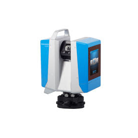
Our company provides comprehensive support from the application for manufacturing subsidies and business restructuring subsidies to the introduction of surveying equipment. Many companies are utilizing subsidies to introduce surveying equipment and laser scanners, and this time we are presenting actual 3D data examples obtained from surveying equipment. [Overview of the Materials] *The relevant document is "Collection of Case Studies on Laser Scanners Introduced Using Subsidies." ■ Recent adoption status of Yokohama Measuring Instruments ■ Breakdown of adopted subsidies ■ Past subsidy introduction achievements and models ■ Actual 3D data examples obtained from surveying equipment [Adoption Rate Achievements (as of May 16, 2022)] ■ Manufacturing Subsidy: 97% (32 out of 33 companies adopted) ■ Business Restructuring Subsidy: 75% (6 out of 8 companies adopted) *Please view the materials from the "Download" link below. *We also conduct meetings and online meetings regarding subsidy application support, so please feel free to let us know if you wish to do so. *For any other inquiries, please do not hesitate to contact us.

  • イプロス用事業再構築補助金表紙?.jpg
  • イプロス用ものづくり補助金表紙?.jpg
  • Development permit application
  • Scanner

Added to bookmarks

Bookmarks list

Bookmark has been removed

Bookmarks list

You can't add any more bookmarks

By registering as a member, you can increase the number of bookmarks you can save and organize them with labels.

Free membership registration

HERON WEARABLE LASER SCANNER

Equipped with two laser scanners oriented horizontally and vertically, stable 360-degree point cloud data can be obtained just by walking!

【Subsidy-Eligible Product】The 'HERON PORTABLE 3D MAPPING SYSTEM (Backpack-type Laser Scanner)' is equipped with two laser scanners directed horizontally and vertically, allowing for the acquisition of 360-degree point cloud data simply by walking. It simultaneously captures Full HD video (1920×1080 pixels / 15fps) while scanning, and for areas requiring high-resolution images, it can stop to take 5K still images (5640×2820 pixels). The real-time 3D data is displayed on a tablet device, enabling measurements while confirming that data is being accurately captured, making it a backpack-type 3D laser scanner. 【Features】 ■ Lightweight ■ Time and cost-saving ■ Usable indoors and outdoors ■ Real-time 3D measurement ■ Easy setup ■ Capable of walking measurements ■ Easy tablet verification ■ Simple software processing *For more details, please refer to the PDF document or contact us directly. ★ This product is a surveying instrument eligible for "subsidy utilization" upon purchase. It may be available for purchase at 1/2 to 1/3 of the regular price! If you are interested, please feel free to contact us.

  • Other measuring instruments
  • Scanner

Added to bookmarks

Bookmarks list

Bookmark has been removed

Bookmarks list

You can't add any more bookmarks

By registering as a member, you can increase the number of bookmarks you can save and organize them with labels.

Free membership registration

Compact ground-based laser scanner 'Leica BLK360 G2'

Lightweight and compact for easy portability! High-speed scanning of up to 680,000 points per second with simple operation.

The "BLK360 G2" can perform a full scan, including spherical images, in just 20 seconds, which is more than five times faster than the conventional BLK360, with just the push of a button. The data from the BLK360 G2 is useful for a wide range of applications, from traditional architecture and construction to innovative VFX (visual effects) and VR (virtual reality). With a scanning speed of up to 680,000 points per second, it can measure up to 45 meters away. Additionally, the data from the BLK360 G2 is beneficial for many applications, from traditional architecture and construction to innovative VFX (visual effects) and VR (virtual reality). For more details, please refer to the product catalog. 【Features】 ■ Lightweight, compact, and affordable 3D laser scanner ■ Easy operation with just the push of a button ★ We provide comprehensive support for the application process for manufacturing subsidies in collaboration with specialized consultants. Please feel free to contact us for more details. ★ Our company offers a variety of surveying equipment and systems, and we can provide proposals tailored to your needs. Please refer to the basic information section for examples of our products.

  • Surveying
  • Other measuring instruments
  • Scanner

Added to bookmarks

Bookmarks list

Bookmark has been removed

Bookmarks list

You can't add any more bookmarks

By registering as a member, you can increase the number of bookmarks you can save and organize them with labels.

Free membership registration

TS measurement and scanner model TOPCON GTL-1200

Solve the challenges of 3D point cloud measurement with an on-site completion workflow!

【Features】 ■ Total station surveying and laser scanning measurements can be performed with one device ■ Point cloud density is twice that of conventional machines ■ Ideal for construction management using BIM ■ Effective for civil engineering, surveying, and maintenance management ■ Equipped with the onboard program MAGNET Field ■ Includes a Wi-Fi module ■ Remote operation via Collage Site is also possible *For more details, please refer to the PDF document or feel free to contact us.

  • Other civil engineering services
  • Surveying
  • Scanner

Added to bookmarks

Bookmarks list

Bookmark has been removed

Bookmarks list

You can't add any more bookmarks

By registering as a member, you can increase the number of bookmarks you can save and organize them with labels.

Free membership registration

Mobile 2D Scanner 'S-2200C/S-2200'

Adapted for high-speed movement, optimal for infrastructure inspection! Measures approximately 2 million points per second, "acquires color point clouds."

Mobile 2D scanner suitable for high-speed distance measurement Acquires color point clouds with 4 built-in cameras (S-2200C) Equipped with 4 calibrated cameras. The cameras and scanner are accurately matched, eliminating the need for calibration during use. The point cloud data is accurately colorized.

  • Other measuring instruments
  • Scanner

Added to bookmarks

Bookmarks list

Bookmark has been removed

Bookmarks list

You can't add any more bookmarks

By registering as a member, you can increase the number of bookmarks you can save and organize them with labels.

Free membership registration