Scanner Product List and Ranking from 178 Manufacturers, Suppliers and Companies | IPROS

Last Updated: Aggregation Period:Jun 24, 2026~Jul 21, 2026
This ranking is based on the number of page views on our site.

Scanner Manufacturer, Suppliers and Company Rankings

Last Updated: Aggregation Period:Jun 24, 2026~Jul 21, 2026
This ranking is based on the number of page views on our site.

  1. 横浜測器 本社 Kanagawa//Trading company/Wholesale
  2. 山陽測器 Hiroshima//Trading company/Wholesale
  3. シンセイコーポレーション Tokyo//Trading company/Wholesale
  4. 4 パルステック工業 Shizuoka//others
  5. 5 FLIGHTS 本社 Tokyo//Information and Communications

Scanner Product ranking

Last Updated: Aggregation Period:Jun 24, 2026~Jul 21, 2026
This ranking is based on the number of page views on our site.

  1. Leica Geosystems' 3D Laser Scanner 'BLK360' 横浜測器 本社
  2. FJD SLAM Scanner Trion P2 山陽測器
  3. Introduction to the TLS (Terrestrial Laser Scanner) Product Lineup 横浜測器 本社
  4. AI Scalp Scanner "with becon" シンセイコーポレーション
  5. 4 Mobile Handheld Scanner HS-X1 横浜測器 本社

Scanner Product List

301~330 item / All 688 items

Displayed results

3D Laser Scanner Trimble X7 FieldLink

A next-generation 3D laser scanner that breaks conventional wisdom for architecture, equipment, and BIM.

The Trimble X7 (for construction and facilities) is a field-completion type 3D laser scanner that quickly captures point clouds on construction sites for structures and facilities, allowing for consistency checks with data created in BIM. ■ Its lightweight and compact design, along with a lightweight and robust carbon tripod, makes it easy to take to the field. ■ Setting up for point cloud measurement is simple, enabling even beginners to easily capture and synthesize point clouds on-site. The synthesized point cloud data can be compared with various 2D/3D design data on a dedicated controller, allowing for on-site completion of tasks from progress management to quality verification. ■ When bringing it to the field for observation, it can measure point clouds according to pre-prepared design data, and even from a state of nothingness, simply observing from multiple arbitrary points will synthesize the point cloud, allowing data to be output on-site. We offer various automatic functions to ensure that even those without specialized surveying knowledge can obtain high-quality point cloud data.

Added to bookmarks

Bookmarks list

Bookmark has been removed

Bookmarks list

You can't add any more bookmarks

By registering as a member, you can increase the number of bookmarks you can save and organize them with labels.

Free membership registration

3D Laser Scanner 【Trimble X12】

The Trimble X12 is a high-end terrestrial laser scanner with top specifications such as high precision, long range, high density, and automatic synthesis.

The Trimble X12 is a high-end terrestrial laser scanner capable of capturing 3D data with high precision, a class-leading measurement range of 365 meters, and a maximum scanning speed of 2,187,000 points per second. It also features a smart light function that allows for clear images to be captured in dark environments. The Trimble X12 combines the world-class scanner from Z+F with Trimble's proprietary Perspective software, which is intuitive to operate. By achieving "full automation" of the processes related to scanning tasks and point cloud synthesis, it allows many tasks that previously took a long time to be completed on-site, resulting in significant time savings, increased efficiency, and cost-effectiveness. The expertise that Trimble has cultivated in terrestrial laser scanning has been consolidated here.

Added to bookmarks

Bookmarks list

Bookmark has been removed

Bookmarks list

You can't add any more bookmarks

By registering as a member, you can increase the number of bookmarks you can save and organize them with labels.

Free membership registration

3D Laser Scanner Trimble X9 Perspective

A next-generation 3D laser scanner that breaks common sense for measurement, civil engineering, and i-Construction.

The Trimble X9 is a ground-based 3D laser scanner that consolidates Trimble's laser scanning technology and further enhances its performance. It evolves the ground-based laser scanner "Trimble X7," which has a strong track record in surveying, construction, and architecture worldwide, while maintaining the high-precision automatic leveling, automatic stitching functions, and calibration features of the Trimble X7. Additionally, the design of the center unit has been revamped. Signal processing necessary for improving scan quality has been enhanced, allowing for reliable and fast scanning of low-reflectivity objects and glossy surfaces such as stainless steel.

Added to bookmarks

Bookmarks list

Bookmark has been removed

Bookmarks list

You can't add any more bookmarks

By registering as a member, you can increase the number of bookmarks you can save and organize them with labels.

Free membership registration

SfM+LiDAR【viDoc RTK rover】

Ground 3D scanning with the accuracy of RTK surveying level.

The viDoc RTK Rover is a real-time kinematic (RTK) device that can be attached to smartphones and tablets provided by Pix4D, allowing for the acquisition of high-precision positioning data. Utilizing GNSS technology, it can obtain location information with an accuracy of a few centimeters, making it suitable for various fields. It works in conjunction with the PIX4Dcatch app, enabling easy high-precision 3D mapping and is ideal for ground-based data acquisition without the use of drones. Data Acquisition Capture assets using the PIX4Dcatch mobile app on your smartphone. Please add the RTK device to improve accuracy. Processing Automatically upload images to PIX4Dcloud for seamless processing or import images from your phone into the PIX4Dmatic desktop app and use the PIX4Dcatch processing template. Export to CAD/BIM/GIS Mark assets as vectors on the point cloud in PIX4Dsurvey and export them in DXF format (for CAD) or SHP format (for GIS).

Added to bookmarks

Bookmarks list

Bookmark has been removed

Bookmarks list

You can't add any more bookmarks

By registering as a member, you can increase the number of bookmarks you can save and organize them with labels.

Free membership registration

Shotcrete 3D Scanner

3D laser scanning of shotcrete in a pit environment

Geokret 2.0 is a complete solution for scanning shotcrete in underground environments, helping to execute shotcrete applications more intelligently. This system enhances safety and durability, avoids unnecessary costs due to material waste, and ensures the highest possible quality of shotcrete. The system is based on a high-precision 3D laser scanner that can send data to a tablet via Wi-Fi, increasing flexibility without the use of cables. (Attach the scanner to a Putzmeister shotcrete machine or the included tripod). It performs high-precision scans at 60 sg around the tunnel in 360 degrees without interrupting the work cycle. Scanning of shotcrete at the portal is also possible.

  • Concrete Machinery
  • Scanner

Added to bookmarks

Bookmarks list

Bookmark has been removed

Bookmarks list

You can't add any more bookmarks

By registering as a member, you can increase the number of bookmarks you can save and organize them with labels.

Free membership registration

Flatbed large-format (A1 to A0 size) scanner

Non-destructive scanning of old drawings and bound drawings! High-speed and high-precision digitization.

Our company offers a high-speed, high-precision scanning service to digitize original materials such as drawings, printed materials, Japanese paper public maps, cadastral maps, and artworks, ranging from A1 to A0 size. The scanning is performed with the original materials placed on a glass surface without moving them, minimizing the risk of damage to valuable documents like Japanese paper public maps and artworks. *Scanning range: Short side: 914mm / Long side: 1270mm This service is suitable for digitizing large bound manuscripts. If you have any other concerns, please feel free to consult us. **Features** - Digitization of drawings up to A0 size - Scanning without damaging bound drawings - Sharp reproduction of the central part of thick bindings *For more details, please download the PDF or feel free to contact us.*

  • Scanner
  • Scanner

Added to bookmarks

Bookmarks list

Bookmark has been removed

Bookmarks list

You can't add any more bookmarks

By registering as a member, you can increase the number of bookmarks you can save and organize them with labels.

Free membership registration

Large Point Cloud Management System "3D-Base"

I no longer care about large point clouds! Batch filtering process.

"3D-Base" is a large point cloud management system with filtering capabilities. It can display cross-sections (vertical and horizontal) within the preview range, allowing users to easily move the position of the cross-section with a simple click and instantly display that cross-section. Additionally, the results of the filtering calculations are reflected in the cross-section display simultaneously. 【Features】 ■ Capable of "2D display," "3D display," "bird's-eye view," and "ortho view" ■ Can display CAD data in the background by importing it ■ Has cross-section calculation functionality ■ Color coordinates can be displayed in a gradient mode if not colored in color mode *For more details, please refer to the PDF materials or feel free to contact us.

  • Other Software
  • Scanner

Added to bookmarks

Bookmarks list

Bookmark has been removed

Bookmarks list

You can't add any more bookmarks

By registering as a member, you can increase the number of bookmarks you can save and organize them with labels.

Free membership registration

Large Point Cloud Management System "3D-BASE PRO"

Batch filtering processing! It is possible to display the Geospatial Information Authority of Japan tiles.

"3D-BASE PRO" is a large point cloud management system with layer and filtering functions. It allows for the creation of triangular meshes and contour lines for each layer, and multiple square meshes can be managed to calculate earthwork volumes through layer comparisons. Additionally, it supports overhangs, filtering overhang data, and generating triangular meshes from slope directions. 【Features】 ■ Management, display, and editing of large point clouds by layer ■ Multiple routes can be created by layer ■ Handling of group layers is possible ■ Addition and editing of shapes using CAD functions ■ Various accuracy management options are available *For more details, please refer to the PDF document or feel free to contact us.

  • Other Software
  • Scanner

Added to bookmarks

Bookmarks list

Bookmark has been removed

Bookmarks list

You can't add any more bookmarks

By registering as a member, you can increase the number of bookmarks you can save and organize them with labels.

Free membership registration

3D Analysis System "AGRI-3D"

Various computational functions! It is also possible to create 3D terrain data, development plans, and color the planning surfaces.

"AGRI-3D" is a three-dimensional analysis system for agricultural consulting. In addition to calculating cross-sectional soil volumes in response to agricultural promotion offices, it also supports various calculations such as measurements between two points, area measurements, and calculations of specified elevation areas. Furthermore, it is capable of 3D visualization of terrain data, development planning, reflecting orthophotos, and coloring of planning surfaces. 【Functions (partial)】 ■ Longitudinal and cross-sectional confirmation ■ Route planning ■ 3D display (aerial photo synthesis) ■ Layer management ■ Contour editing and contour elevation display ■ Tracing function *For more details, please refer to the PDF materials or feel free to contact us.

  • Other Software
  • Scanner

Added to bookmarks

Bookmarks list

Bookmark has been removed

Bookmarks list

You can't add any more bookmarks

By registering as a member, you can increase the number of bookmarks you can save and organize them with labels.

Free membership registration

Mesh soil volume and transportation calculation system 'CUBOIII'

Agricultural land business, residential land development, dam construction, etc.! A must-have for engineers requiring earth volume calculations.

"CUBOIII" is a mesh volume and transportation calculation system that supports triangular mesh height calculations and dramatically improves calculation speed. In the creation of transportation blocks and transportation planning, automatic calculation of soil volume movement is possible. It is also possible to create deposition points, and movement from the soil volume collected at these points can be performed. Additionally, in movement editing, waypoints can also be established. 【Features (partial)】 ■ Mesh line cross-section / arbitrary line cross-section ■ Creation of mesh points ■ Setting of soil volume calculation work areas ■ Height settings ■ Creation of transportation blocks / transportation planning ■ Layered color display based on height and soil volume *For more details, please refer to the PDF materials or feel free to contact us.

  • Other Software
  • Scanner

Added to bookmarks

Bookmarks list

Bookmark has been removed

Bookmarks list

You can't add any more bookmarks

By registering as a member, you can increase the number of bookmarks you can save and organize them with labels.

Free membership registration

For those struggling with compensation surveys, we will solve your problems with 3D measurement.

Our 3D measurement is also useful for "field surveys" and "drawing creation" in compensation investigations.

This video is aimed at contractors conducting compensation surveys. Our 3D measurement is also useful for the "field survey" and "drawing creation" of compensation surveys. We provide our customers with data that has been scanned at high density. The data we provide allows you to measure distances with just a click, enabling you to perform measurements from your PC instead of doing them one by one on-site. Please be sure to watch until the end! *For more details, please refer to the PDF materials or feel free to contact us.

  • Other measuring instruments
  • Scanner

Added to bookmarks

Bookmarks list

Bookmark has been removed

Bookmarks list

You can't add any more bookmarks

By registering as a member, you can increase the number of bookmarks you can save and organize them with labels.

Free membership registration

What can be done by measuring with a 3D scanner?

We measured the J. Survey building with a 3D laser scanner.

We measured the J. Survey building with a 3D laser scanner. Since the entire building has been scanned, the creation of drawings and modeling is accurate! If you have any questions, please feel free to contact us. We hope you enjoy reading until the end! *For more details, please refer to the PDF document or feel free to contact us.

  • Other measuring instruments
  • Scanner

Added to bookmarks

Bookmarks list

Bookmark has been removed

Bookmarks list

You can't add any more bookmarks

By registering as a member, you can increase the number of bookmarks you can save and organize them with labels.

Free membership registration

What is measurable 3D photography? It's an era where you can conduct surveys without going to the site!

With "measurable 3D photos," when measured with a 3D scanner, it looks like a photo, but you can measure the dimensions of your favorite places as much as you like.

With "measurable 3D photos," when measured with a 3D scanner, it looks like a photograph, but surprisingly!! You can measure the dimensions of your favorite places as much as you like. In the current COVID-19 situation! Why not conduct a site survey without visiting the location??? If you have any questions, please feel free to contact us. We hope you enjoy reading until the end! *For more details, please refer to the PDF document or feel free to contact us.

  • Other measuring instruments
  • Scanner

Added to bookmarks

Bookmarks list

Bookmark has been removed

Bookmarks list

You can't add any more bookmarks

By registering as a member, you can increase the number of bookmarks you can save and organize them with labels.

Free membership registration

3D measurement (measurement to modeling)

Our company conducts measurements using a 3D laser scanner.

We measured the entire building from the exterior to the interior using a 3D scanner and digitized the data! Additionally, we performed modeling. It is also possible to conduct simulations from the modeling! Please be sure to watch until the end! *For more details, please refer to the PDF document or feel free to contact us.

  • Other measuring instruments
  • Surveying
  • Scanner

Added to bookmarks

Bookmarks list

Bookmark has been removed

Bookmarks list

You can't add any more bookmarks

By registering as a member, you can increase the number of bookmarks you can save and organize them with labels.

Free membership registration

3D Scanner『XVS』

Select suitable images using smart algorithms to enhance the model's accuracy.

The "XVS" is a 3D scanner that can reconstruct the textures of scanned materials very clearly and realistically based on advanced high-resolution images. By using automatic target detection and an inertial system, it can achieve optimized results. Additionally, due to its practicality and ease of use, many people, including those in companies or universities, can use it without prior knowledge of 3D scanning. 【Features】 ■ Accurate ■ HD Texture ■ Optimized Results ■ Easy to Use ■ Diverse *For more details, please download the PDF or feel free to contact us.

Added to bookmarks

Bookmarks list

Bookmark has been removed

Bookmarks list

You can't add any more bookmarks

By registering as a member, you can increase the number of bookmarks you can save and organize them with labels.

Free membership registration

Laser Scanner『X120GO』

Three integrated 5MP cameras cover the scanner's wide measurement range.

The "X120GO" is a laser scanner with a laser that rotates 360° at the top, capable of acquiring and generating point clouds within a range of 360° x 270°. By simply walking around the area you want to measure, you can capture the entire three-dimensional point cloud data and retrieve it immediately as data. Additionally, you can start the operation just by pressing the start button, making data acquisition more efficient and convenient. 【Features】 ■ Labor-saving in work time ■ Flexibility ■ Real-time preview ■ Automatic acquisition of control points ■ Integrated camera *For more details, please download the PDF or feel free to contact us.

Added to bookmarks

Bookmarks list

Bookmark has been removed

Bookmarks list

You can't add any more bookmarks

By registering as a member, you can increase the number of bookmarks you can save and organize them with labels.

Free membership registration

M&A brokerage services for veterinary hospitals

An experienced professional team will support the realization of M&A (business succession) that both parties will not regret.

Our company provides M&A brokerage services for veterinary hospitals. We take pride in our track record of securing over 500 grants for veterinary hospitals, and with numerous connections to many veterinary clinics, we leverage our knowledge and connections to support M&A. For more details or inquiries, please feel free to contact us. 【Features】 ■ A team of experts to ensure successful business succession ■ Connections with many veterinary hospitals across the country ■ Low fees through the utilization of grants *For more information, please download the PDF or feel free to contact us.

  • others
  • Scanner

Added to bookmarks

Bookmarks list

Bookmark has been removed

Bookmarks list

You can't add any more bookmarks

By registering as a member, you can increase the number of bookmarks you can save and organize them with labels.

Free membership registration

Germany Ultra-High-Resolution Small Nano-Focus CT diondo dsubµ

The highest resolution sub-micro CT system for materials research, featuring a compact and most sophisticated structure, for the analysis of three-dimensional structures in materials research.

The diondo dsubµ is a compact nano-focus CT device developed for the purpose of analyzing the three-dimensional structure of materials during research and analysis processes. It can capture the finest structures of three-dimensional fiber-reinforced materials or organic materials with nano-focus resolution. ● Innovative Detector System A detector system equipped with three different fields of view and an sCMOS camera. It scans samples with a minimum of 0.3 μm/voxel and captures a maximum measurement volume of up to 5 mm (1.4 μm/voxel scan). ● Compact Design All peripherals are integrated to make the system compact. ● High-Precision Mechanical System High precision is achieved by adopting a linear shaft system and an air-floating high-precision turntable.

  • Other analytical equipment
  • Non-destructive testing
  • Analysis and prediction system
  • Scanner

Added to bookmarks

Bookmarks list

Bookmark has been removed

Bookmarks list

You can't add any more bookmarks

By registering as a member, you can increase the number of bookmarks you can save and organize them with labels.

Free membership registration

Germany Universal Sub-Micro Focus Industrial CT diondo d2

Universal sub-microfocus industrial CT specially designed for the analysis and measurement of small and medium-sized components.

This system can be used for a wide range of applications, from non-destructive testing analysis to high-precision coordinate measurement technology compliant with VDI/VDE 2630 1.3 standards, and product production management. The diondo d2 universal sub-microfocus industrial CT system sets new standards in both scientific research and industry due to its extremely high adaptability. ▪ High-resolution 3D analysis 3D analysis from low-density materials to complete assemblies ▪ Optional dual-tube configuration A combination of micro and nano-focus X-ray tubes up to 300kV achieves excellent penetration and high-precision resolution ▪ Multi-axis granite machine system Allows for free adjustment of the distance between the beam focus and the detector to achieve optimal resolution imaging. ▪ Various functional modules Enables autonomous measurement operations and on-site analysis, among other capabilities.

  • Other analytical equipment
  • Non-destructive testing
  • Analysis and prediction system
  • Scanner

Added to bookmarks

Bookmarks list

Bookmark has been removed

Bookmarks list

You can't add any more bookmarks

By registering as a member, you can increase the number of bookmarks you can save and organize them with labels.

Free membership registration

Germany Sub-Micro Focus Industrial CT diondo d5

Low thermal expansion granite stage! High-output X-ray source and high-resolution detector capable of mounting two types of detectors for X-ray inspection and 3D analysis to detect defects!

The diondo d5 is specially designed for customers who require performance, size, and equipment compatibility. With a high-output X-ray source and high-resolution detectors combined with a precision mechanical system of up to 9 axes, it enables innovative leaps in flexibility and performance. ▪ Various combinations available Equipped with up to 2 tubes and 2 detectors to meet specific testing needs. ▪ Innovative software package Supports a wide range of inspection solutions, including spiral CT, scatter correction, and planar CT imaging. ▪ Coordinate measurement technology Meets the highest measurement requirements with reproducible 3D measurement technology compliant with VDI/VDE 2630-1.3 standards. ▪ Granite mechanical system Can be equipped with up to 9 motor-driven axes for maximum flexibility. ▪ On-site loading capability Provides personalized testing solutions under limited testing conditions.

  • Other analytical equipment
  • Non-destructive testing
  • Analysis and prediction system
  • Scanner

Added to bookmarks

Bookmarks list

Bookmark has been removed

Bookmarks list

You can't add any more bookmarks

By registering as a member, you can increase the number of bookmarks you can save and organize them with labels.

Free membership registration

Germany diondo Industrial CT Measurement Service - Chip - Electronics and Electrical

Low cost, high precision, accurate non-destructive testing from 50,000 yen per specimen.

Starting from 50,000 yen (excluding tax) / 1 sample *Sample transportation costs (generally, the customer is responsible for sample transportation costs) 【Measurement Contents】 Defect Analysis - Pore Analysis Dimensional Measurement *For other measurement contents, please inquire. 【Delivery Data】 Measurement Report + Original Report Image + Defect Statistics Table 【CT Scanner Specifications】 Model Name: General-purpose Micro/Nano CT System diondo d2 Reflection Target X-ray Tube: 190-300kV Transmission Target X-ray Tube: 160-300kV Area Array Detector: 3000 × 3000px, 139μm Focal Length Range: 400-1200mm, adjustable Maximum Effective Detection Range: Ø520×H650mm Maximum Load Capacity: 50kg diControl Software Functions: DR Function, Spiral CT, Angle Limited Scan, High-speed CT, High-speed Reconstruction GPU Acceleration, Beam Hardening Correction, Artifact Correction, Batch Automatic Detection, Automatic Geometry Correction, Daily Detection, Status Detection, Measurement Module VDI/VDE 2630 【Inquiries and Estimates】 Email: info@nd-seiko.co.jp Phone: 0538-84-9600

  • Non-destructive testing
  • Structural Survey
  • Geological Survey
  • Scanner

Added to bookmarks

Bookmarks list

Bookmark has been removed

Bookmarks list

You can't add any more bookmarks

By registering as a member, you can increase the number of bookmarks you can save and organize them with labels.

Free membership registration

No problem without drawings with 3D scanning! Case study of a factory.

Measure within a limited time! You can investigate in detail on the data.

No problem if you don't have building plans! We will introduce a case where factory plans were easily surveyed using 3D scanning. This is perfect for building demolition and renovations. Due to the height and the often complex arrangement of equipment and piping, manual measurement can be time-consuming and costly. However, with our product, even high and complex areas can be measured in a short time, helping to reduce costs. Additionally, during the day, it was difficult to conduct thorough surveys while the factory was in operation, but measurements can be taken in a limited time, and further detailed investigation can be done on the data afterward. 【Case Overview】 ■ Challenges - Often high and complex arrangements of equipment and piping, leading to time and effort consumption. ■ Benefits - Capable of measuring complex areas in a short time. - Allows for detailed investigation on the data. *For more details, please download the PDF or feel free to contact us. *We listen to each customer's concerns and requests through phone calls, emails, and meetings, providing careful proposals and prompt responses to deliver peace of mind and trust.

  • Surveying
  • Scanner

Added to bookmarks

Bookmarks list

Bookmark has been removed

Bookmarks list

You can't add any more bookmarks

By registering as a member, you can increase the number of bookmarks you can save and organize them with labels.

Free membership registration

Support available nationwide! Accurately and quickly design facilities with a "3D scanner."

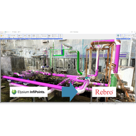
Transfer point clouds and created CAD models to "Rebro"! We create data that enables efficient and accurate modeling and design.

Our company saves spaces as point cloud data using a 3D laser scanner and creates data tailored to our customers' needs. The point cloud processing software we use, "InfiPoints," is linked with the 3D CAD software "Rebro," which is specifically designed for architectural equipment design. This allows us to transfer CAD models created from point clouds in InfiPoints to Rebro, enabling the creation of data that aids in efficient modeling and design. Additionally, not only can we create CAD models, but we can also overlay point cloud data in Rebro to understand the detailed existing conditions, allowing for accurate and quick drafting of replacement parts. Features: - More accurate than manual surveying and reduces labor (3D scanning typically requires two people). - Work in Rebro is focused only on fine shape adjustments and connections. - Accurate modeling by operating in Rebro while viewing the point cloud. The utilization of point cloud data obtained from 3D scanning extends beyond just creating Rebro data; we also propose various other applications such as 3D modeling, drafting, BIM data creation, collision verification, and structural analysis through CAE. Of course, we also perform scanning alone.

  • Scanner
  • Drawing, tracing, CAD
  • Facility Design
  • Scanner

Added to bookmarks

Bookmarks list

Bookmark has been removed

Bookmarks list

You can't add any more bookmarks

By registering as a member, you can increase the number of bookmarks you can save and organize them with labels.

Free membership registration

Restore drawings with 3D scanning too! First-time service campaign ongoing!

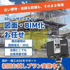
Digitally preserve the current situation! Create drawings, 3D models, BIM, and perspectives! We also conduct on-site surveys and simulations.

We digitally preserve spaces as point clouds using a 3D laser scanner and create data tailored to specific purposes. Due to the ability to digitize reality, it has garnered attention in the construction industry as a central player in digital transformation (DX), and point clouds can now be handled by many CAD software programs. In equipment design, representative examples include "Rebro" and "Tfas," which can convert point cloud data into formats that can be imported into software. While there are various other capabilities, I believe it may be difficult to visualize just from the materials provided. Therefore, to help you understand the usefulness of 3D scanners, we are conducting an initial introduction service campaign! We will survey the site at a discounted price and guide you on what can be achieved. If you have any questions about what can be done, what kind of machine a 3D scanner is, or the details of the initial introduction service, please feel free to contact us. What can be done with 3D scanning: ■ Increased efficiency in creating equipment design drawings ■ New drawing creation and restoration ■ 3D CAD, BIM, and perspective creation ■ Reduction of on-site surveys ■ Reduction of interference issues through simulations

  • Drawing, tracing, CAD
  • Scanner

Added to bookmarks

Bookmarks list

Bookmark has been removed

Bookmarks list

You can't add any more bookmarks

By registering as a member, you can increase the number of bookmarks you can save and organize them with labels.

Free membership registration

Film scanning and telecine

Digitalization is carried out using a scanner that can operate even with deteriorated film!

We would like to introduce our "Film Scanning and Telecine" services. "Film scanning" is the process of capturing each frame of film as digital data. After converting to digital data, we perform color grading and digital restoration to finalize the video. Additionally, we also conduct "telecine," which involves direct color grading and noise reduction from film, converting it into video formats such as professional VTR and DVD. 【Specifications for Film Scanning】 ■ Supported films: 35mm, 16mm, 8mm, 28mm, 17.5mm, 9.5mm ■ Output resolutions: 5K, 4K, UHD, 2K, HD, SD ■ Output formats: DPX, TIFF, ProRes, QuickTime, etc. *For more details, please refer to the PDF document or feel free to contact us.

  • Other services and technologies
  • Scanner

Added to bookmarks

Bookmarks list

Bookmark has been removed

Bookmarks list

You can't add any more bookmarks

By registering as a member, you can increase the number of bookmarks you can save and organize them with labels.

Free membership registration

Mobile 3D Mapping Scanner 'MK3'

Acquire point cloud data while walking. Reduce work time by up to 1/10!

The "MK3" is a mobile 3D mapping scanner that can capture spatial point clouds while walking. Compared to stationary models, it can reduce work time by up to 90%. No separate PC or USB memory is required for data processing. With our proprietary SLAM technology, processing is executed simultaneously with scanning, allowing for quick handling of large point cloud data. File format conversion is also possible, making it effective if you want to use the point cloud data obtained with the MK3 in another application. 【Features】 ■ Capture point clouds while walking ■ Built-in original point cloud processing software ■ Significant reduction in work time with high-speed processing ■ Easy operation *For more details, please download the PDF or feel free to contact us.

  • Structural Survey
  • Scanner

Added to bookmarks

Bookmarks list

Bookmark has been removed

Bookmarks list

You can't add any more bookmarks

By registering as a member, you can increase the number of bookmarks you can save and organize them with labels.

Free membership registration

3D measurement

Achieving safe and accurate 3D measurement in a short time! Geometric shapes are also output as point cloud data.

We would like to introduce our "3D Measurement" services. Measurement, of course, but also construction planning and modeling can be widely utilized. It enables the sharing of operations across various sections using just a single point cloud data. Please feel free to contact us when you need our services. 【Features】 ■ Geometric shapes can be output as point cloud data ■ Wide range of applications including modeling ■ Operations across various sections can be shared using just a single point cloud data *For more details, please download the PDF or feel free to contact us.

  • Other services and technologies
  • Scanner

Added to bookmarks

Bookmarks list

Bookmark has been removed

Bookmarks list

You can't add any more bookmarks

By registering as a member, you can increase the number of bookmarks you can save and organize them with labels.

Free membership registration

Architectural Exterior: "Measurement and Surveying Services"

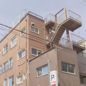
We accurately record the current situation that cannot be understood through photos or drawings using 3D data.

The "Architectural Exterior Measurement and Surveying Service" of 3Dims LLC is a service that accurately measures and records the exterior of existing buildings. Utilizing 3D laser scanners, it precisely captures building dimensions, shapes, and facades that were difficult to grasp with traditional manual methods or photogrammetry. The acquired data can be used for renovation design, seismic retrofitting, remodeling plans, and facility management. It provides the current state of the building's exterior as readily usable digital data, supporting the efficiency and accuracy of design and construction.

  • Company:3dims
  • Price:Other
  • Renovation
  • Surveying
  • Drawing, tracing, CAD
  • Scanner

Added to bookmarks

Bookmarks list

Bookmark has been removed

Bookmarks list

You can't add any more bookmarks

By registering as a member, you can increase the number of bookmarks you can save and organize them with labels.

Free membership registration

3D scanner "Matter and Form THREE"

Thoroughly scans down to the details! A high-performance 3D scanner that excels in any scene.

"Matter and Form THREE" is a high-performance 3D scanner capable of scanning everything from the fine surface of a coin to large parts like a car engine with great detail. Equipped with a high-precision 13-megapixel optical sensor from Sony and an advanced DLP MEMS mirror projector, it combines reliability and flexibility. It operates using software that runs in a web browser, eliminating the need for a high-spec PC and avoiding subscription fees. 【Features】 ■ Browser software that works on any PC ■ High resolution of up to 0.037mm ■ Full-color scanning support *For more details, please download the PDF or feel free to contact us.

  • others
  • Scanner

Added to bookmarks

Bookmarks list

Bookmark has been removed

Bookmarks list

You can't add any more bookmarks

By registering as a member, you can increase the number of bookmarks you can save and organize them with labels.

Free membership registration

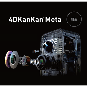
4DKanKanMeta

A next-generation 4D platform that allows you to easily create 3D virtual spaces and freely customize experience design.

4DKanKan Meta is a platform based on the concept of "3D virtual space × time = 4D experience," allowing anyone to easily create virtual spaces using a camera, app, and cloud. The ultra-high-precision scanning of 905nm LiDAR can collect a modeling range of up to 70m with a single point scan, generating high-resolution point cloud data with 16K HD images widely used in construction, government, healthcare, education, museums, and the BIM industry. With the SLAM function, 3D space design and creation can be done using only the captured materials, eliminating the need for large-scale equipment. The camera itself has been made lightweight at 2.9kg, making it easy to carry while still enabling high-quality shooting, thus expanding its applications across various uses.

  • Other measuring instruments
  • Scanner

Added to bookmarks

Bookmarks list

Bookmark has been removed

Bookmarks list

You can't add any more bookmarks

By registering as a member, you can increase the number of bookmarks you can save and organize them with labels.

Free membership registration