Achieving vertical takeoff and landing without a runway while enabling long-distance flight. Streamlining wide-area inspections, patrols, and surveys for erosion control, dams, rivers, roads, and railways.
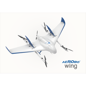
The "AeroBowing AS-VT02K" is a domestically produced VTOL fixed-wing drone that combines vertical takeoff and landing with long-distance and wide-area flight capabilities. While inheriting the flight performance and practicality of conventional models introduced in 2020, it has improved safety performance, weather resistance, portability, and ease of use in the field based on operational results and feedback from companies and local governments across the country. In terms of safety, it is equipped with a fail-safe function that automatically transitions from fixed-wing flight to multi-copter mode in the event of significant loss of aircraft attitude. It also supports automatic return in case of radio disconnection or low battery, automatic landing in the event of GPS anomalies, and emergency stop and hovering with a one-button operation. With dust and drip-proof performance equivalent to IP43, it is designed for operation in field environments, including light rain. The aircraft can be transported in two cases and is structured for assembly without tools, making it easier to utilize in mountainous areas and disaster sites. It can carry payloads such as still images, videos, and infrared cameras according to its applications. LTE communication is standard, and it also optionally supports the Smart River Spot (SRS) developed by the Ministry of Land, Infrastructure, Transport and Tourism.
Inquire About This Product
basic information
■Main Specifications Dimensions: 2,100×1,200×400mm (excluding propellers) Weight: 10kg (including battery) / Maximum takeoff weight 11.6kg Maximum payload capacity: 1.6kg Flight time: Up to 70 minutes Flight distance: Up to 80km Speed: Maximum 100km/h / Cruising 72km/h Maximum wind speed for flight: 10m/s (during fixed-wing flight) Dust and water resistance: IP43 GNSS and communication: Dual-frequency GNSS / 2.4GHz band, LTE, SRS radio (optional) Main safety features: Automatic transition to multi-copter mode in emergencies, emergency stop and hovering, automatic return and landing, automatic pre-flight inspection
Price range
Delivery Time
Applications/Examples of results
- Inspection of erosion control facilities - Wide-area observation of agricultural, forestry, and fishery resources - Patrol and condition survey of rivers - Long-distance inspection of roads and railways - Assessment of damage during disasters - Investigation and inspection of port areas 【Many implementation results in domestic and international companies and government agencies】
Detailed information
-
Not only can you consult us about the introduction of the aircraft, but also about operational training, flight plan creation, remote operation, and the delivery of acquired data and deliverables. We also regularly hold flight observation events. Please feel free to apply.
catalog(1)
Download All Catalogs![[Wide Area Inspection/Survey] Domestic VTOL-type Drone "AeroBowwing" Product Catalog](https://image.www.ipros.com/public/catalog/image/2071760/IPROS6898841045879856646.jpeg?w=120&h=170)
Company information

We will contribute to society by bringing transformation with cutting-edge drones, AI, and cloud technology, automating various tasks in the real world.
![Top 10 Reasons to Fly Fixed-Wing Drones [Part 1]](https://image.www.ipros.com/public/product/image/bff/2001099471/IPROS63903542832504015410.png?w=280&h=280)
![[Case Study of Mapping Drones] Observation of Wildlife and Environmental Conservation](https://image.www.ipros.com/public/product/image/9a1/2001099468/IPROS86532114210659206017.png?w=280&h=280)

![Top 10 Reasons to Fly Fixed-Wing Drones [Part 2]](https://image.www.ipros.com/public/product/image/26d/2001099473/IPROS57683071126592201529.png?w=280&h=280)