It is possible to obtain survey data in places where people cannot enter! Significantly reduce the time and cost associated with data collection.
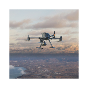
Our company conducts surveying using UAVs (drones) as a method compliant with i-Construction. Based on numerous images taken to overlap the surveying area, we orthorectify them and generate point cloud data. This data can be utilized for volume calculations and civil engineering design. Compared to traditional surveying, we can significantly reduce the time and costs associated with measurements and data collection. 【Features】 ■ Significant reduction in surveying time ■ Major labor savings in fieldwork ■ Ensured safety in field operations ■ Significant improvement in measurement accuracy ■ Documentation of the site *For more details, please refer to the PDF materials or feel free to contact us.

Inquire About This Product
basic information
**Advantages of Aerial Photogrammetry with UAVs** - High-resolution data can be obtained due to low-altitude shooting - Can be used for construction management with 3D models - Measurement data can be obtained in areas inaccessible to people - Generally, there is no need to stop construction *For more details, please refer to the PDF document or feel free to contact us.*
Price range
Delivery Time
Applications/Examples of results
【Examples】 ■UAV surveying case for public works and civil engineering projects ■UAV surveying case for offshore breakwaters ■UAV surveying case for hazardous areas during disasters *For more details, please refer to the PDF document or feel free to contact us.
Company information
"The Era of Utilizing Drones for Infrastructure Inspections and Maintenance" Many infrastructures, such as roads, bridges, and tunnels, which were constructed en masse during the period of rapid economic growth, are now over 50 years old, and inspections have not kept pace, leading to neglect. For example, the Ministry of Land, Infrastructure, Transport and Tourism mandated in 2014 that bridges and tunnels over 2 meters in height undergo regular inspections through close visual checks every five years, but issues due to personnel and budget shortages have arisen. As a result, the introduction of drones for some inspections has begun to gain attention, and we are now in an era where drone operations are commonplace. Towa Drone Service supports the digital transformation (DX) of customer sites by 3D modeling infrastructure inspections and survey data for public and power sectors. Executives President and CEO: Junichi Soma Vice President: Shinji Kanazawa Executive Officer: Kazue Ota Executive Officer: Hideaki Kazui Executive Officer: Yuji Takiguchi Auditor: Kazushi Ishino


![[Drone Aircraft Insurance] Peace of mind with drone insurance even when lending out the aircraft.](https://image.www.ipros.com/public/product/image/ca6/2000941971/IPROS27704151671106637978.png?w=280&h=280)


