An electronic compass is built into the surface tilt meter to measure the angle of tilt in any direction. It can also be used for real-time detection for safety monitoring during construction and for observing structures.
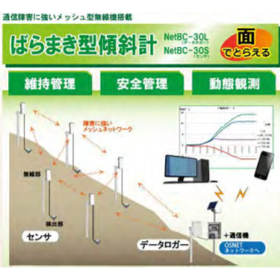
"Merex-CR" is an inclinometer that measures the slope angle and orientation in real-time (once every 0.3 seconds) in areas at risk of collapse or tilting, and outputs an alarm when preset values (cumulative, time, daily, weekly displacement) are exceeded. With remote communication capabilities, data can be checked and collected without entering hazardous areas. Additionally, the main unit is inexpensive and easy to install, allowing for an increase or decrease in the number of units based on scale. 【Features】 ■ Real-time measurement function ■ High expandability ■ Easy installation and relocation ■ Alarm output function *For more details, please download the PDF or feel free to contact us.

Inquire About This Product
basic information
【Specifications (Excerpt)】 ■ Inclination Angle Measurement ・Measurement Range: ±30° ・Measurement Resolution: 0.025° ・Measurement Accuracy: ±0.5° ■ Azimuth Measurement ・Measurement Range: 0° to 360° ・Measurement Accuracy: ±15° ■ Size: φ70mm × H280mm ■ Weight: 760g *For more details, please download the PDF or feel free to contact us.
Price information
Please contact us.
Price range
P3
Delivery Time
P3
Applications/Examples of results
【Purpose】 ■ Simple measurement of hazardous areas on slopes (rockfalls, debris flows, collapses, landslides, etc.) ■ Safety management of cut slopes and excavation slopes during construction ■ Maintenance management of civil engineering structures (bridges, tunnels, transmission towers, retaining walls, etc.) *For more details, please download the PDF or feel free to contact us.
catalog(1)
Download All Catalogs
Company information

We are a company that contributes to the creation of a safe and secure society by developing disaster prevention and mitigation projects nationwide, based on geospatial information technology and enhancing core technologies such as geological survey techniques and disaster prevention technologies for landslides and slope disasters.