iPROS Urban Planning
  • Search for products by classification category

    • Building Materials
      Building Materials
      36493items
    • Facilities
      Facilities
      58406items
    • Lighting and Interior
      Lighting and Interior
      17626items
    • Common materials
      Common materials
      37190items
    • Civil Engineering Materials
      Civil Engineering Materials
      10250items
    • Construction, work and methods
      Construction, work and methods
      29166items
    • Surveys, Measurements, and Services
      Surveys, Measurements, and Services
      29609items
    • IT/Software
      IT/Software
      33694items
    • others
      others
      92093items
    • Store and facility supplies
      Store and facility supplies
      4635items
    • Office and commercial supplies
      Office and commercial supplies
      11759items
    • Hospital and welfare facility supplies
      Hospital and welfare facility supplies
      1059items
    • Logistics Equipment
      Logistics Equipment
      7378items
    • Energy and Resources
      Energy and Resources
      11966items
  • Search for companies by industry

    • Information and Communications
      7299
    • others
      7226
    • Building materials, supplies and fixtures manufacturers
      6665
    • Service Industry
      4791
    • Trading company/Wholesale
      3100
    • Other construction industries
      2456
    • Electrical equipment construction business
      756
    • Construction Consultant
      645
    • General contractors and subcontractors
      577
    • Interior Design
      520
    • Facility Design Office
      487
    • Housing manufacturers and construction companies
      442
    • Architectural design office
      364
    • retail
      363
    • Warehousing and transport related industries
      332
    • Building Management
      298
    • Electricity, Gas and Water Industry
      286
    • Interior construction business
      283
    • Medical and Welfare
      278
    • Educational and Research Institutions
      255
    • Renovation and home construction industry
      225
    • Water supply and drainage construction business
      202
    • Transportation
      179
    • Real Estate Developers
      169
    • Fisheries, Agriculture and Forestry
      136
    • Structural Design Office
      65
    • Finance, securities and insurance
      41
    • Restaurants and accommodations
      33
    • self-employed
      31
    • Mining
      26
    • Public interest/special/independent administrative agency
      20
    • Police, Fire Department, Self-Defense Forces
      17
    • Property Owner
      9
    • Store and building owners
      9
    • Government
      9
    • Individual
      9
  • Special Features
  • Ranking

    • Overall Products Ranking
    • Overall Company Ranking
Search for Products
  • Search for products by classification category

  • Building Materials
  • Facilities
  • Lighting and Interior
  • Common materials
  • Civil Engineering Materials
  • Construction, work and methods
  • Surveys, Measurements, and Services
  • IT/Software
  • others
  • Store and facility supplies
  • Office and commercial supplies
  • Hospital and welfare facility supplies
  • Logistics Equipment
  • Energy and Resources
Search for Companies
  • Search for companies by industry

  • Information and Communications
  • others
  • Building materials, supplies and fixtures manufacturers
  • Service Industry
  • Trading company/Wholesale
  • Other construction industries
  • Electrical equipment construction business
  • Construction Consultant
  • General contractors and subcontractors
  • Interior Design
  • Facility Design Office
  • Housing manufacturers and construction companies
  • Architectural design office
  • retail
  • Warehousing and transport related industries
  • Building Management
  • Electricity, Gas and Water Industry
  • Interior construction business
  • Medical and Welfare
  • Educational and Research Institutions
  • Renovation and home construction industry
  • Water supply and drainage construction business
  • Transportation
  • Real Estate Developers
  • Fisheries, Agriculture and Forestry
  • Structural Design Office
  • Finance, securities and insurance
  • Restaurants and accommodations
  • self-employed
  • Mining
  • Public interest/special/independent administrative agency
  • Police, Fire Department, Self-Defense Forces
  • Property Owner
  • Store and building owners
  • Government
  • Individual
Special Features
Ranking
  • Overall Products Ranking
  • Overall Company Ranking
  • privacy policy
  • terms of service
  • About Us
  • Careers
  • Advertising
  1. Home
  2. Trading company/Wholesale
  3. 横浜測器 本社
  4. We will be exhibiting at the 6th Construction and Surveying Productivity Improvement Exhibition (CSPI-EXPO 2024)!
COMPANY
  • Mar 22, 2024
  • Added to bookmarks

    Bookmarks list

    Bookmark has been removed

    Bookmarks list

    You can't add any more bookmarks

    By registering as a member, you can increase the number of bookmarks you can save and organize them with labels.

    Free membership registration
Mar 22, 2024

We will be exhibiting at the 6th Construction and Surveying Productivity Improvement Exhibition (CSPI-EXPO 2024)!

横浜測器 横浜測器 本社
We are pleased to announce our participation in the 6th Construction and Surveying Productivity Improvement Expo (CSPI-EXPO 2024). We will provide explanations on remote operation of total stations and consulting for equipment introduction utilizing subsidies! Please feel free to stop by our booth. 【Exhibition Content】 - Remote operation of total stations - Consulting for equipment introduction utilizing subsidies and more Venue: Makuhari Messe Halls 1-6, Outdoor Exhibition Area, Outdoor Exhibition Area ANNEX Dates: May 22 (Wed), 23 (Thu), and 24 (Fri), 2024, from 10:00 to 17:00 [until 16:00 on the final day, May 24] Booth Location: Exhibition Hall 4, 11-51
  • Inquiry about this news

    Contact Us Online

Related product

ダウンロード.jpg

Fully autonomous flying laser scanner "Leica BLK2FLY"

Orders will start in Japan from March 1, 2024! Fully autonomous flying laser scanner Leica BLK2FLY.

The "Leica BLK2FLY" can perform 3D scanning in hard-to-reach places such as ceilings and roofs, both indoors and outdoors. It captures the exterior of buildings, structures, and environments, creating 3D point clouds while in flight. It can be activated with just a few taps on a tablet, allowing for aerial scanning of structures and environments. Aerial scanning is beneficial for accurately capturing the features and dimensions of a structure's exterior, especially in cases where access is difficult or where it is hard to reach. 【Features】 ■ One-button operation ■ No calibration required for flight ■ Safe and stress-free flight enabled by obstacle detection features ■ Easy creation of automated flight plans from the operating application

  • Other civil engineering services
  • Surveying

Added to bookmarks

Bookmarks list

Bookmark has been removed

Bookmarks list

You can't add any more bookmarks

By registering as a member, you can increase the number of bookmarks you can save and organize them with labels.

Free membership registration
イプロス用補助金表紙.jpg

Compact ground-based laser scanner 'Leica BLK360 G2'

Lightweight and compact for easy portability! High-speed scanning of up to 680,000 points per second with simple operation.

The "BLK360 G2" can perform a full scan, including spherical images, in just 20 seconds, which is more than five times faster than the conventional BLK360, with just the push of a button. The data from the BLK360 G2 is useful for a wide range of applications, from traditional architecture and construction to innovative VFX (visual effects) and VR (virtual reality). With a scanning speed of up to 680,000 points per second, it can measure up to 45 meters away. Additionally, the data from the BLK360 G2 is beneficial for many applications, from traditional architecture and construction to innovative VFX (visual effects) and VR (virtual reality). For more details, please refer to the product catalog. 【Features】 ■ Lightweight, compact, and affordable 3D laser scanner ■ Easy operation with just the push of a button ★ We provide comprehensive support for the application process for manufacturing subsidies in collaboration with specialized consultants. Please feel free to contact us for more details. ★ Our company offers a variety of surveying equipment and systems, and we can provide proposals tailored to your needs. Please refer to the basic information section for examples of our products.

  • Surveying
  • Other measuring instruments

Added to bookmarks

Bookmarks list

Bookmark has been removed

Bookmarks list

You can't add any more bookmarks

By registering as a member, you can increase the number of bookmarks you can save and organize them with labels.

Free membership registration
イプロス用補助金表紙.jpg

SLAM technology Mobile handheld laser scanner BLK2GO

While walking through the space, you can scan large buildings, structures, and environments at an unprecedented speed and with ease.

The BLK2GO performs millions of high-precision measurements simply by pressing a button to power it on and walking around, recreating the surrounding space in 3D. The data from the BLK2GO serves as the foundational data for accurate floor plans, BIM models, and 3D visualizations. With a scanning speed of up to 420,000 points per second, it can measure up to 25 meters away. 【Features】 ■ Lightweight, compact, and affordable 3D laser scanner ■ Easy operation with just a button press ■ Rechargeable battery allows for continuous scanning for 45 minutes ★ We provide comprehensive support for the application process for manufacturing subsidies in collaboration with specialized consultants. Please feel free to contact us for more details. ★ Our company offers a variety of surveying equipment and systems, allowing us to make proposals tailored to your needs. Please refer to the basic information section for examples of our products.

  • Surveying
  • Other measuring instruments

Added to bookmarks

Bookmarks list

Bookmark has been removed

Bookmarks list

You can't add any more bookmarks

By registering as a member, you can increase the number of bookmarks you can save and organize them with labels.

Free membership registration
ttl.png

[Eligible for IT Introduction Subsidy!] Wingneo INFINITY 2025

Announcement of the launch of the latest version of CAD software "Wingneo INFINITY 2025" for the surveying, civil engineering design, and registration industries.

Linking groundbreaking observation instruments in the new era of measurement digitalization to support observation, editing, and results. The system will be updated and released as the latest version! Scheduled sales start date: March 19, 2024 (Tuesday) Standard price: 1,155,000 yen (including tax) and up

  • Other measuring instruments

Added to bookmarks

Bookmarks list

Bookmark has been removed

Bookmarks list

You can't add any more bookmarks

By registering as a member, you can increase the number of bookmarks you can save and organize them with labels.

Free membership registration
image_01.jpg

CAD『WingNeo INFINITY』

Supporting measurement and registration services! Delivering workflows and enhanced features born from customer feedback.

"WingNeo INFINITY" incorporates innovations that allow it to handle both office tasks and fieldwork with a single device. When taken out to the field as a mobile unit, it enables tasks such as wave observation, traverse calculations, and diagramming that are desired on-site. Tasks that were previously performed using standalone applications like electronic field notebooks or electronic tablets can now be accomplished simply by carrying the INFINITY license. [Features] ■ Addition of CAD text and text attachment ■ Main screen switching ■ Utilization of Exif information from commercially available cameras ■ CAD surface transparency settings ■ Strengthened relationship between pages and editing tasks *For more details, please refer to the PDF materials or feel free to contact us.

  • Drawing, tracing, CAD
  • Other measuring instruments

Added to bookmarks

Bookmarks list

Bookmark has been removed

Bookmarks list

You can't add any more bookmarks

By registering as a member, you can increase the number of bookmarks you can save and organize them with labels.

Free membership registration
cad.png

Large-scale point cloud editing tool "Wing Earth"

[Subsidy-eligible products] Breaking through the barriers of existing businesses, the key to inspiration is 3D point clouds!

We would like to introduce our large-scale point cloud editing tool, 'Wing Earth.' Starting with "shape representation using normal vectors from point clouds without color information (aerial surveys)," it also includes features such as "visualization of sediment control dam installation images" and "shape data creation for remodeling and renovation," among many others, offering various usage methods. If you are looking for a 3D point cloud tool, please feel free to consult us. *For more details, please refer to our catalog or PDF materials, or feel free to contact us. ★This product is a surveying instrument eligible for "subsidy utilization" upon purchase. It may be available for purchase at 1/2 to 1/3 of the regular price! If you are interested, please do not hesitate to contact us. *Purchasing the equipment simultaneously is a condition.

  • Other Software

Added to bookmarks

Bookmarks list

Bookmark has been removed

Bookmarks list

You can't add any more bookmarks

By registering as a member, you can increase the number of bookmarks you can save and organize them with labels.

Free membership registration
image_01.jpg

Large-scale 3D point cloud high-speed editing tool 'Wing Earth'

[Subsidy-eligible products] Thoroughly pursuing production workflows using 3D point clouds! Comfortable processing of large-volume point clouds!

"Wing Earth" is a three-dimensional point cloud processing tool that performs volume calculations, heat map creation, and output of construction acceptance judgment summary tables based on point cloud data obtained through three-dimensional measurement using fixed three-dimensional laser scanners, MMS, etc. This tool is equipped with high-speed three-dimensional point cloud processing capabilities that allow for the loading of point cloud data exceeding 10 billion points, achieving overwhelming high-speed display of point clouds. Additionally, it features the ability to recognize vehicles, people, and signs as a single entity with just a click on a point in the point cloud, enabling fast and easy deletion and management of objects in just a few seconds. [Features] - Capable of handling a wide range of related data, both general and specialized - Visually and intuitively guides users through each step of the process to achieve the desired results with high usability *For more details, please refer to the catalog or PDF materials, or feel free to contact us. ★ This product is a surveying instrument eligible for "subsidy utilization" upon purchase. It may be available for purchase at a price of 1/2 to 1/3 of the regular price! If you are interested, please do not hesitate to contact us. *Condition applies: Purchase must be made simultaneously with the equipment.

  • Other Software
  • others

Added to bookmarks

Bookmarks list

Bookmark has been removed

Bookmarks list

You can't add any more bookmarks

By registering as a member, you can increase the number of bookmarks you can save and organize them with labels.

Free membership registration
image_05.jpg

Laser scanner "Leica ScanStation P50"

[Subsidy-eligible products] Accurately measure details! Generate high-quality and realistic 3D color point cloud data.

The "Leica ScanStation P50" is a laser scanner equipped with long-range scanning capabilities that reliably captures details. It can measure up to 1 million points per second and quickly measure distances exceeding 1 km, generating the highest quality 3D data and HDR images. Additionally, it complies with the IP54 standard for waterproof and dustproof performance. 【Features】 ■ High performance even in harsh environments ■ Excellent measurement range and angular accuracy ■ Operates in extreme temperature conditions from -20°C to +50°C ■ Comprehensive solutions including software, services, training, and support *For more details, please refer to the PDF document or feel free to contact us. ★ This product is a surveying instrument eligible for "subsidy utilization" upon purchase. It may be available for purchase at a price of 1/2 to 1/3 of the regular price! If you are interested, please do not hesitate to contact us.

  • Other civil engineering services
  • Other measuring instruments
  • Measurement and analysis equipment leasing and rental

Added to bookmarks

Bookmarks list

Bookmark has been removed

Bookmarks list

You can't add any more bookmarks

By registering as a member, you can increase the number of bookmarks you can save and organize them with labels.

Free membership registration
3d_laser_scanner_02_822d8f8fca-300x362.jpg

Acquisition of realistic point cloud data is possible with Z+F IMAGER 5016.

[Subsidy-eligible products] Achieve 3D modeling at low cost with ultra-fast and ultra-high precision scanning! Providing new solutions that were previously difficult to realize!

The "PENTAX Z+F IMAGER 5016 Laser Scanner" achieves a compact and lightweight design while incorporating advanced HDR camera capabilities, built-in navigation system, and high-speed Wi-Fi functionality without compromising on the advantages of high precision, high scan rate, and low range noise provided by the phase difference method! It comes standard with an LED light for color photography in dark environments (capable of illuminating up to 10m). Equipped with high-speed Wi-Fi, it enables real-time high-speed data transfer of measurement data to a Tablet PC using the included IMAGER5016 dedicated software "LC SCOUT"! It allows for simultaneous verification of 3D point cloud data during measurement, significantly improving productivity. 【Features】 ■ Achieves 3D reality capture in a short time ■ Portable design that can be stored in a backpack *For more details, please refer to the PDF document or feel free to contact us. ★ This product is a surveying instrument eligible for "subsidy utilization" upon purchase. It may be available for purchase at 1/2 to 1/3 of the regular price! If you are interested, please do not hesitate to contact us.

  • Other measuring instruments

Added to bookmarks

Bookmarks list

Bookmark has been removed

Bookmarks list

You can't add any more bookmarks

By registering as a member, you can increase the number of bookmarks you can save and organize them with labels.

Free membership registration
image_4044.png

[Subsidy-eligible product] Laser scanner Leica RTC360

Speedy, portable, and high precision! Equipped with seamless automatic data transfer functionality from the field to the office.

The "Leica RTC360 Laser Scanner" features a measurement speed of up to 2 million points per second and an advanced HDR imaging system, allowing for the acquisition of color 3D point cloud data in just 2 minutes. With its target-free automatic registration function powered by VIS technology and seamless automatic data transfer from the field to the office, it significantly reduces field measurement time and greatly enhances productivity. 【Features】 ■ Achieves 3D reality capture in a short time ■ Portable design and foldable dedicated tripod can be stored in a backpack ■ Can be carried anywhere ■ Simply go to the site and perform a quick and easy scan with a single button operation ★ This product qualifies as surveying equipment eligible for "subsidy utilization" upon purchase. It may be available for purchase at 1/2 to 1/3 of the regular price! If you are interested, please feel free to contact us. * For more details, please refer to the PDF materials or feel free to reach out to us.

  • Other measuring instruments

Added to bookmarks

Bookmarks list

Bookmark has been removed

Bookmarks list

You can't add any more bookmarks

By registering as a member, you can increase the number of bookmarks you can save and organize them with labels.

Free membership registration
2018-12-20_17h07_13.png

3D/2D Laser Scanner "PENTAX S Series"

[Subsidy-eligible products] Supports various scanning methods. Acquires clear point cloud data in a short time.

The "PENTAX S Series" is a 3D and 2D laser scanner that supports high-speed scanning at one million points per second. It includes the 3D laser scanner "S-3180," which captures clear point cloud data with extremely low noise in a short time, and the 2D laser scanner "S-2100." 【Product Lineup】 ■ 3D Laser Scanner "S-3180V" ■ 3D Laser Scanner "S-3180" ■ 2D Laser Scanner "S-2100" *For more details, please refer to the PDF document or feel free to contact us. ★ This product is a surveying instrument eligible for "subsidy utilization" upon purchase. It may be available for purchase at a price of 1/2 to 1/3 of the regular price! If you are interested, please do not hesitate to contact us.

  • Distance measuring device/length measuring device
  • Other measuring instruments

Added to bookmarks

Bookmarks list

Bookmark has been removed

Bookmarks list

You can't add any more bookmarks

By registering as a member, you can increase the number of bookmarks you can save and organize them with labels.

Free membership registration
image_4043.png

Leica ScanStation P30/40

Introducing a 3D laser scanner that operates in harsh temperature environments from -20℃ to +50℃!

The "Leica ScanStation P30/40" is an ideal laser scanner that ensures accurate measurement time, measurement range, precision, and durability while reliably capturing details. It has a maximum measurement distance of 270 meters and generates high-quality 3D data and HDR images at a speed of 1 million points per second. With excellent measurement range and angular accuracy, as well as low range noise and two-axis compensation suitable for surveying, it produces high-quality, realistic 3D color point cloud data. 【Features】 ■ Reliable detail measurement ■ The right choice ■ High performance even in harsh environments ■ Reduced downtime ■ Total scanning system *For more details, please refer to the PDF document or feel free to contact us.

  • Other measuring instruments

Added to bookmarks

Bookmarks list

Bookmark has been removed

Bookmarks list

You can't add any more bookmarks

By registering as a member, you can increase the number of bookmarks you can save and organize them with labels.

Free membership registration
スクリーンショット 2021-05-27 104639.png

Latest Case Studies of Point Clouds

Introducing point cloud data obtained from a laser scanner that measures various objects with excellent productivity, versatility, and operability!

Introducing point cloud data obtained from the latest laser scanner product lineup provided by Yokohama Measuring Instruments Co., Ltd.! The selection of the appropriate model is crucial depending on the intended use of the laser scanner. We offer the most suitable laser scanner for our customers from a wide range of models. The point cloud data acquired by leveraging the characteristics and features of each model has the potential to significantly impact our customers' future business development. 【Point Cloud Data by Characteristics】 ■ UAV Laser Scanner Point Cloud Data ■ Long-range Ground Laser Scanner Point Cloud Data ■ Mid-range Ground Laser Scanner Point Cloud Data ■ Compact and Lightweight Ground Laser Scanner Point Cloud Data *For more details, please refer to the catalog or PDF materials, or feel free to contact us.

  • Surveying
  • Other measuring instruments

Added to bookmarks

Bookmarks list

Bookmark has been removed

Bookmarks list

You can't add any more bookmarks

By registering as a member, you can increase the number of bookmarks you can save and organize them with labels.

Free membership registration

Related catalog(14)

[Eligible for IT Introduction Subsidy!] Electronic Tablet and Surveying CAD System 'WingNeo INFINITY 2025' Materials

[Eligible for IT Introduction Subsidy!] Electronic Tablet and Surveying CAD System 'WingNeo INFINITY 2025' Materials

OTHER
  • E-book viewing
  • Catalog download

Contact this catalog

【Eligible for IT Introduction Subsidy!】Electronic Tablet and Surveying CAD System 'WingNeo INFINITY 2024' Materials

【Eligible for IT Introduction Subsidy!】Electronic Tablet and Surveying CAD System 'WingNeo INFINITY 2024' Materials

OTHER
  • E-book viewing
  • Catalog download

Contact this catalog

Large-scale 3D point cloud high-speed editing tool "Wing Earth"

Large-scale 3D point cloud high-speed editing tool "Wing Earth"

PRODUCT
  • E-book viewing
  • Catalog download

Contact this catalog

[Latest Equipment] Fully Autonomous Flight Laser Scanner "Leica BLK2FLY"

[Latest Equipment] Fully Autonomous Flight Laser Scanner "Leica BLK2FLY"

PRODUCT
  • E-book viewing
  • Catalog download

Contact this catalog

19th Manufacturing Subsidy Flyer

19th Manufacturing Subsidy Flyer

PRODUCT
  • E-book viewing
  • Catalog download

Contact this catalog

Introduction Materials: "A Guide to Grant Applications"

Introduction Materials: "A Guide to Grant Applications"

OTHER
  • E-book viewing
  • Catalog download

Contact this catalog

Flyer "Recommendation for Applying for Manufacturing Subsidies"

Flyer "Recommendation for Applying for Manufacturing Subsidies"

OTHER
  • E-book viewing
  • Catalog download

Contact this catalog

Introduction Material: "A Guide to Applying for Manufacturing Subsidies"

Introduction Material: "A Guide to Applying for Manufacturing Subsidies"

OTHER
  • E-book viewing
  • Catalog download

Contact this catalog

[Subsidy-eligible product] PENTAX Z+F IMAGER5016 Laser Scanner

[Subsidy-eligible product] PENTAX Z+F IMAGER5016 Laser Scanner

PRODUCT
  • E-book viewing
  • Catalog download

Contact this catalog

[Subsidy-eligible product] 'Leica RTC360' 3D reality capture solution

[Subsidy-eligible product] 'Leica RTC360' 3D reality capture solution

OTHER
  • E-book viewing
  • Catalog download

Contact this catalog

3D Laser Scanner "ScanStation P30/40" Product Information

3D Laser Scanner "ScanStation P30/40" Product Information

OTHER
  • E-book viewing
  • Catalog download

Contact this catalog

[Subsidy-eligible product] NORBIT-WINGHEAD Ultra High-Resolution Narrow Multi-Beam Sonar

[Subsidy-eligible product] NORBIT-WINGHEAD Ultra High-Resolution Narrow Multi-Beam Sonar

PRODUCT
  • E-book viewing
  • Catalog download

Contact this catalog

【Subsidy-eligible Product】NORBIT-iWBMS High-Resolution Narrow Multi-Beam Sonar

【Subsidy-eligible Product】NORBIT-iWBMS High-Resolution Narrow Multi-Beam Sonar

PRODUCT
  • E-book viewing
  • Catalog download

Contact this catalog

Point Cloud Data Case Studies

Point Cloud Data Case Studies

OTHER
  • E-book viewing
  • Catalog download

Contact this catalog

Distributors

横浜測器
Trading company/Wholesale
  • Added to bookmarks

    Bookmarks list

    Bookmark has been removed

    Bookmarks list

    You can't add any more bookmarks

    By registering as a member, you can increase the number of bookmarks you can save and organize them with labels.

    Free membership registration
横浜測器 本社
  • Special site
  • Official site
Phone number/address

news

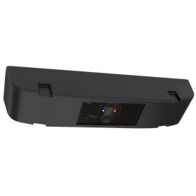
CCS3 product photo

The new product "Vehicle Count Sensor CCS3" enables efficient occupancy management of large parking lots.

  • NEW
  • PRODUCT

Hotron Inc. has launched its new product, the "Vehicle Count Sensor CCS3"! This product is a ceiling-mounted sensor that combines infrared and radar technology. It reliably detects vehicles in both directions with a single unit, accommodating traffic during congestion and vehicle passing, thus achieving efficient occupancy management in large parking lots. Additionally, it can be utilized for exit warning purposes in addition to vehicle counting, contributing to the safe and smooth operation of parking facilities. 'Features' - Improved detection performance against changes in road surface during rainy weather by using both infrared and radar. - Equipped with IP67 waterproof and dustproof performance, making it effective even in salt damage areas. - Various settings can be configured from a dedicated app (for Android devices), with current settings easily visible at a glance. - The base dimensions are the same as the previous model "CCS2," allowing for smooth replacement of existing equipment. *For more details, please refer to the product information, catalog download, or contact us.*

Oct 16, 2026

Added to bookmarks

Bookmarks list

Bookmark has been removed

Bookmarks list

You can't add any more bookmarks

By registering as a member, you can increase the number of bookmarks you can save and organize them with labels.

Free membership registration

[Video Manual Guide] We will explain in an easy-to-understand video how to connect the wireless set that links the bed exit sensor and nurse call system!

  • NEW
  • OTHER

Hotron, which manufactures and sells sensors, provides bed exit sensors for hospitals, nursing, and care facilities. Hotron offers easy-to-understand video guidance on how to use bed exit sensors wirelessly and how to set up device connections! ▼ Video Manual (YouTube) https://www.youtube.com/playlist?list=PLNVA4mTrZDqtJa6MfFRZQxwtfCSnAfxVy 【Bed Exit Sensors】 ○ Non-contact infrared sensor, simply place it - Pole-kun HB-H1 ○ Mat sensor, foldable thin mat - Mat-kun HB-UST ○ Body movement call - Ugo-kun HB-TV3 ○ Body movement call for wheelchairs - Ayumi-chan HB-WTV3 【Options】 ○ Nurse call linked wireless set - Wireless set (transmitter/receiver) HB-RS/HB-RJ ◎ For more information about the products, please contact us or download the catalog.

Oct 15, 2026

Added to bookmarks

Bookmarks list

Bookmark has been removed

Bookmarks list

You can't add any more bookmarks

By registering as a member, you can increase the number of bookmarks you can save and organize them with labels.

Free membership registration
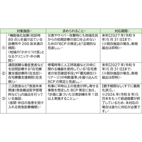
The establishment of BCP has become essential primarily for medical institutions that have reported the following facility standards.

[2026 Medical Fee Revision] Important Notice Regarding the Formulation of BCP for Medical Institutions | Target Facilities and Response by the End of May 2027 and Facility Standards

  • NEW
  • COMPANY

Knowledge Lean Co., Ltd. "Can the field operate with just a 'created' BCP? - The true preparations and burden reduction approaches that medical institutions should know by May 2027." Due to the revision of medical service fees in fiscal year 2026, the formulation and regular review of "Business Continuity Plans (BCP)" have become essential requirements for many medical institutions. There is a tendency to think that "BCPs are something created by large disaster response hospitals," but the focus of this revision by the government is on the "frontline of community healthcare," which is most closely connected to our daily lives. The formulation of a BCP is not merely "administrative work" to avoid penalties; it is an "investment in the management foundation" to protect the safety of patients and staff in times of crisis and to solidify trust as an infrastructure of community healthcare. Please feel free to inquire, including a check of your institution's current status. We will fully support the creation of "truly usable and efficient preparations" while minimizing the burden on medical sites. Knowledge Lean Co., Ltd.

Oct 15, 2026

Added to bookmarks

Bookmarks list

Bookmark has been removed

Bookmarks list

You can't add any more bookmarks

By registering as a member, you can increase the number of bookmarks you can save and organize them with labels.

Free membership registration
HK-2

Recommended for earthquake measures for automatic doors and equipment! Seismic device HK-2.

  • NEW
  • PRODUCT

Japan is one of the top 10 countries in the world with frequent earthquakes. The 2020 White Paper on Land, Infrastructure, Transport and Tourism has also reported an increase in the probability of major earthquakes occurring. Regarding the Nankai Trough earthquake, the probability of an earthquake with a magnitude of 8 to 9 occurring within the next 30 years is estimated to be 70 to 80%. At Hotron, we recommend the introduction of seismic devices for earthquake countermeasures in buildings and equipment. The seismic device 'HK-2' is a product that automatically performs various controls that have been pre-set when it detects strong shaking equivalent to a seismic intensity of 5 lower or higher. For example, it can automatically execute actions such as: "Open automatic doors and gates to secure evacuation routes and access for emergency vehicles" "Transmit signals to the control room and stop facility equipment" "Unlock the keys to locked lockers" "Automatically play voice guidance" For more details, please download the materials or contact us.

Oct 14, 2026

Added to bookmarks

Bookmarks list

Bookmark has been removed

Bookmarks list

You can't add any more bookmarks

By registering as a member, you can increase the number of bookmarks you can save and organize them with labels.

Free membership registration

[Exhibition Information] 47th Annual Conference of the Japan Society for Occupational Environment Measurement / Society of Occupational Health Engineering (10/21-10/23)

  • NEW
  • COMPANY

We will be exhibiting at the "47th Annual Conference of the Japan Society for Occupational Environment Measurement / Occupational Health Engineering Society Exhibition of Occupational Environment Measurement Related Equipment." We plan to showcase protective clothing and other safety and health protective gear. We look forward to your visit! ● Date: October 21 (Wednesday) to October 23 (Friday), 2026 ● Venue: Ehime Prefectural Culture Hall If you have any questions, please feel free to contact us through the related link [Protective Clothing Wisdom.com]. [Protective Clothing Wisdom.com] is a comprehensive information site operated by Azeas Co., Ltd. for a safe working environment.

Oct 14, 2026

Added to bookmarks

Bookmarks list

Bookmark has been removed

Bookmarks list

You can't add any more bookmarks

By registering as a member, you can increase the number of bookmarks you can save and organize them with labels.

Free membership registration
Return to news list
  • 目的・課題から技術・サービスを探せる リノベーション・リフォーム専門サイト
    • Inquiry about this news

      Contact Us Online

    Products

    • Search for Products

    Company

    • Search for Companies

    Special Features

    • Special Features

    Ranking

    • Overall Products Ranking
    • Overall Company Ranking

    support

    • site map
    IPROS
    • privacy policy Regarding external transmission of information
    • terms of service
    • About Us
    • Careers
    • Advertising
    IPROS Services
    • >IPROS GMS | Search site for the manufacturing industry
    • >IPROS | Search site for the B2B industry
    COPYRIGHT © 2001-2026 IPROS CORPORATION ALL RIGHTS RESERVED.
    Please note that the English text on this page is automatically translated and may contain inaccuracies.