iPROS Urban Planning
  • Search for products by classification category

    • Building Materials
      Building Materials
      36707items
    • Facilities
      Facilities
      57275items
    • Lighting and Interior
      Lighting and Interior
      17485items
    • Common materials
      Common materials
      37160items
    • Civil Engineering Materials
      Civil Engineering Materials
      9979items
    • Construction, work and methods
      Construction, work and methods
      28637items
    • Surveys, Measurements, and Services
      Surveys, Measurements, and Services
      29698items
    • IT/Software
      IT/Software
      33212items
    • others
      others
      80762items
    • Store and facility supplies
      Store and facility supplies
      4579items
    • Office and commercial supplies
      Office and commercial supplies
      11646items
    • Hospital and welfare facility supplies
      Hospital and welfare facility supplies
      1023items
    • Logistics Equipment
      Logistics Equipment
      7268items
    • Energy and Resources
      Energy and Resources
      12048items
  • Search for companies by industry

    • Information and Communications
      7304
    • others
      7193
    • Building materials, supplies and fixtures manufacturers
      6577
    • Service Industry
      4699
    • Trading company/Wholesale
      3022
    • Other construction industries
      2426
    • Electrical equipment construction business
      636
    • Interior Design
      519
    • Facility Design Office
      491
    • Construction Consultant
      480
    • retail
      360
    • Architectural design office
      356
    • Warehousing and transport related industries
      324
    • General contractors and subcontractors
      321
    • Electricity, Gas and Water Industry
      287
    • Interior construction business
      279
    • Medical and Welfare
      274
    • Building Management
      262
    • Educational and Research Institutions
      253
    • Renovation and home construction industry
      222
    • Water supply and drainage construction business
      203
    • Housing manufacturers and construction companies
      190
    • Transportation
      164
    • Real Estate Developers
      157
    • Fisheries, Agriculture and Forestry
      127
    • Structural Design Office
      65
    • Finance, securities and insurance
      40
    • self-employed
      31
    • Restaurants and accommodations
      30
    • Mining
      26
    • Public interest/special/independent administrative agency
      20
    • Police, Fire Department, Self-Defense Forces
      17
    • Store and building owners
      9
    • Government
      9
    • Individual
      9
    • Property Owner
      8
  • Special Features
  • Ranking

    • Overall Products Ranking
    • Overall Company Ranking
Search for Products
  • Search for products by classification category

  • Building Materials
  • Facilities
  • Lighting and Interior
  • Common materials
  • Civil Engineering Materials
  • Construction, work and methods
  • Surveys, Measurements, and Services
  • IT/Software
  • others
  • Store and facility supplies
  • Office and commercial supplies
  • Hospital and welfare facility supplies
  • Logistics Equipment
  • Energy and Resources
Search for Companies
  • Search for companies by industry

  • Information and Communications
  • others
  • Building materials, supplies and fixtures manufacturers
  • Service Industry
  • Trading company/Wholesale
  • Other construction industries
  • Electrical equipment construction business
  • Interior Design
  • Facility Design Office
  • Construction Consultant
  • retail
  • Architectural design office
  • Warehousing and transport related industries
  • General contractors and subcontractors
  • Electricity, Gas and Water Industry
  • Interior construction business
  • Medical and Welfare
  • Building Management
  • Educational and Research Institutions
  • Renovation and home construction industry
  • Water supply and drainage construction business
  • Housing manufacturers and construction companies
  • Transportation
  • Real Estate Developers
  • Fisheries, Agriculture and Forestry
  • Structural Design Office
  • Finance, securities and insurance
  • self-employed
  • Restaurants and accommodations
  • Mining
  • Public interest/special/independent administrative agency
  • Police, Fire Department, Self-Defense Forces
  • Store and building owners
  • Government
  • Individual
  • Property Owner
Special Features
Ranking
  • Overall Products Ranking
  • Overall Company Ranking
  • privacy policy
  • terms of service
  • About Us
  • Careers
  • Advertising
  1. Home
  2. Trading company/Wholesale
  3. 横浜測器 本社
  4. [Latest Equipment Information] Lightweight and Compact GNSS Receiver 'HiPer CR' Compatible with Multi-GNSS
PRODUCT
  • Mar 13, 2024
  • Added to bookmarks

    Bookmarks list

    Bookmark has been removed

    Bookmarks list

    You can't add any more bookmarks

    By registering as a member, you can increase the number of bookmarks you can save and organize them with labels.

    Free membership registration
Mar 13, 2024

[Latest Equipment Information] Lightweight and Compact GNSS Receiver 'HiPer CR' Compatible with Multi-GNSS

横浜測器 横浜測器 本社
Our company, Yokohama Measurement Instruments, has announced the release of the new antenna-integrated GNSS receiver 'HiPer CR' from TOPCON, which features a lightweight and compact body and high positioning performance compatible with multi-GNSS. This GNSS receiver significantly improves the efficiency of surveying work through its advanced positioning capabilities and the mobility of its compact design. 【Basic Information】 ■ Compatible with all satellites ■ Easy and simple interface ■ Compatible with hybrid survey systems ■ LongLink data communication ■ Built-in battery with 10 hours of operation
  • Inquiry about this news

    Contact Us Online

Related product

hipercr.jpeg

High positioning performance and lightweight design for faster surveying work! GNSS receiver

High positioning performance and a simple interface will change surveying work!

【Features】 ■Compatible with all satellites ■Ultra-compact and robust body ■Easy and simple interface ■Compatible with hybrid survey systems ■LongLink data communication ■Built-in battery with 10 hours of operation *For more details, please refer to the PDF document or feel free to contact us.

  • Other civil engineering services
  • Surveying

Added to bookmarks

Bookmarks list

Bookmark has been removed

Bookmarks list

You can't add any more bookmarks

By registering as a member, you can increase the number of bookmarks you can save and organize them with labels.

Free membership registration
ダウンロード.jpg

Fully autonomous flying laser scanner "Leica BLK2FLY"

Orders will start in Japan from March 1, 2024! Fully autonomous flying laser scanner Leica BLK2FLY.

The "Leica BLK2FLY" can perform 3D scanning in hard-to-reach places such as ceilings and roofs, both indoors and outdoors. It captures the exterior of buildings, structures, and environments, creating 3D point clouds while in flight. It can be activated with just a few taps on a tablet, allowing for aerial scanning of structures and environments. Aerial scanning is beneficial for accurately capturing the features and dimensions of a structure's exterior, especially in cases where access is difficult or where it is hard to reach. 【Features】 ■ One-button operation ■ No calibration required for flight ■ Safe and stress-free flight enabled by obstacle detection features ■ Easy creation of automated flight plans from the operating application

  • Other civil engineering services
  • Surveying

Added to bookmarks

Bookmarks list

Bookmark has been removed

Bookmarks list

You can't add any more bookmarks

By registering as a member, you can increase the number of bookmarks you can save and organize them with labels.

Free membership registration
イプロス用補助金表紙.jpg

Compact ground-based laser scanner 'Leica BLK360 G2'

Lightweight and compact for easy portability! High-speed scanning of up to 680,000 points per second with simple operation.

The "BLK360 G2" can perform a full scan, including spherical images, in just 20 seconds, which is more than five times faster than the conventional BLK360, with just the push of a button. The data from the BLK360 G2 is useful for a wide range of applications, from traditional architecture and construction to innovative VFX (visual effects) and VR (virtual reality). With a scanning speed of up to 680,000 points per second, it can measure up to 45 meters away. Additionally, the data from the BLK360 G2 is beneficial for many applications, from traditional architecture and construction to innovative VFX (visual effects) and VR (virtual reality). For more details, please refer to the product catalog. 【Features】 ■ Lightweight, compact, and affordable 3D laser scanner ■ Easy operation with just the push of a button ★ We provide comprehensive support for the application process for manufacturing subsidies in collaboration with specialized consultants. Please feel free to contact us for more details. ★ Our company offers a variety of surveying equipment and systems, and we can provide proposals tailored to your needs. Please refer to the basic information section for examples of our products.

  • Surveying
  • Other measuring instruments

Added to bookmarks

Bookmarks list

Bookmark has been removed

Bookmarks list

You can't add any more bookmarks

By registering as a member, you can increase the number of bookmarks you can save and organize them with labels.

Free membership registration
イプロス用補助金表紙.jpg

SLAM technology Mobile handheld laser scanner BLK2GO

While walking through the space, you can scan large buildings, structures, and environments at an unprecedented speed and with ease.

The BLK2GO performs millions of high-precision measurements simply by pressing a button to power it on and walking around, recreating the surrounding space in 3D. The data from the BLK2GO serves as the foundational data for accurate floor plans, BIM models, and 3D visualizations. With a scanning speed of up to 420,000 points per second, it can measure up to 25 meters away. 【Features】 ■ Lightweight, compact, and affordable 3D laser scanner ■ Easy operation with just a button press ■ Rechargeable battery allows for continuous scanning for 45 minutes ★ We provide comprehensive support for the application process for manufacturing subsidies in collaboration with specialized consultants. Please feel free to contact us for more details. ★ Our company offers a variety of surveying equipment and systems, allowing us to make proposals tailored to your needs. Please refer to the basic information section for examples of our products.

  • Surveying
  • Other measuring instruments

Added to bookmarks

Bookmarks list

Bookmark has been removed

Bookmarks list

You can't add any more bookmarks

By registering as a member, you can increase the number of bookmarks you can save and organize them with labels.

Free membership registration
3d_laser_scanner_02_822d8f8fca-300x362.jpg

Acquisition of realistic point cloud data is possible with Z+F IMAGER 5016.

[Subsidy-eligible products] Achieve 3D modeling at low cost with ultra-fast and ultra-high precision scanning! Providing new solutions that were previously difficult to realize!

The "PENTAX Z+F IMAGER 5016 Laser Scanner" achieves a compact and lightweight design while incorporating advanced HDR camera capabilities, built-in navigation system, and high-speed Wi-Fi functionality without compromising on the advantages of high precision, high scan rate, and low range noise provided by the phase difference method! It comes standard with an LED light for color photography in dark environments (capable of illuminating up to 10m). Equipped with high-speed Wi-Fi, it enables real-time high-speed data transfer of measurement data to a Tablet PC using the included IMAGER5016 dedicated software "LC SCOUT"! It allows for simultaneous verification of 3D point cloud data during measurement, significantly improving productivity. 【Features】 ■ Achieves 3D reality capture in a short time ■ Portable design that can be stored in a backpack *For more details, please refer to the PDF document or feel free to contact us. ★ This product is a surveying instrument eligible for "subsidy utilization" upon purchase. It may be available for purchase at 1/2 to 1/3 of the regular price! If you are interested, please do not hesitate to contact us.

  • Other measuring instruments

Added to bookmarks

Bookmarks list

Bookmark has been removed

Bookmarks list

You can't add any more bookmarks

By registering as a member, you can increase the number of bookmarks you can save and organize them with labels.

Free membership registration
image_4044.png

[Subsidy-eligible product] Laser scanner Leica RTC360

Speedy, portable, and high precision! Equipped with seamless automatic data transfer functionality from the field to the office.

The "Leica RTC360 Laser Scanner" features a measurement speed of up to 2 million points per second and an advanced HDR imaging system, allowing for the acquisition of color 3D point cloud data in just 2 minutes. With its target-free automatic registration function powered by VIS technology and seamless automatic data transfer from the field to the office, it significantly reduces field measurement time and greatly enhances productivity. 【Features】 ■ Achieves 3D reality capture in a short time ■ Portable design and foldable dedicated tripod can be stored in a backpack ■ Can be carried anywhere ■ Simply go to the site and perform a quick and easy scan with a single button operation ★ This product qualifies as surveying equipment eligible for "subsidy utilization" upon purchase. It may be available for purchase at 1/2 to 1/3 of the regular price! If you are interested, please feel free to contact us. * For more details, please refer to the PDF materials or feel free to reach out to us.

  • Other measuring instruments

Added to bookmarks

Bookmarks list

Bookmark has been removed

Bookmarks list

You can't add any more bookmarks

By registering as a member, you can increase the number of bookmarks you can save and organize them with labels.

Free membership registration
2018-12-20_17h07_13.png

3D/2D Laser Scanner "PENTAX S Series"

[Subsidy-eligible products] Supports various scanning methods. Acquires clear point cloud data in a short time.

The "PENTAX S Series" is a 3D and 2D laser scanner that supports high-speed scanning at one million points per second. It includes the 3D laser scanner "S-3180," which captures clear point cloud data with extremely low noise in a short time, and the 2D laser scanner "S-2100." 【Product Lineup】 ■ 3D Laser Scanner "S-3180V" ■ 3D Laser Scanner "S-3180" ■ 2D Laser Scanner "S-2100" *For more details, please refer to the PDF document or feel free to contact us. ★ This product is a surveying instrument eligible for "subsidy utilization" upon purchase. It may be available for purchase at a price of 1/2 to 1/3 of the regular price! If you are interested, please do not hesitate to contact us.

  • Distance measuring device/length measuring device
  • Other measuring instruments

Added to bookmarks

Bookmarks list

Bookmark has been removed

Bookmarks list

You can't add any more bookmarks

By registering as a member, you can increase the number of bookmarks you can save and organize them with labels.

Free membership registration
image_05.jpg

Laser scanner "Leica ScanStation P50"

[Subsidy-eligible products] Accurately measure details! Generate high-quality and realistic 3D color point cloud data.

The "Leica ScanStation P50" is a laser scanner equipped with long-range scanning capabilities that reliably captures details. It can measure up to 1 million points per second and quickly measure distances exceeding 1 km, generating the highest quality 3D data and HDR images. Additionally, it complies with the IP54 standard for waterproof and dustproof performance. 【Features】 ■ High performance even in harsh environments ■ Excellent measurement range and angular accuracy ■ Operates in extreme temperature conditions from -20°C to +50°C ■ Comprehensive solutions including software, services, training, and support *For more details, please refer to the PDF document or feel free to contact us. ★ This product is a surveying instrument eligible for "subsidy utilization" upon purchase. It may be available for purchase at a price of 1/2 to 1/3 of the regular price! If you are interested, please do not hesitate to contact us.

  • Other civil engineering services
  • Other measuring instruments
  • Measurement and analysis equipment leasing and rental

Added to bookmarks

Bookmarks list

Bookmark has been removed

Bookmarks list

You can't add any more bookmarks

By registering as a member, you can increase the number of bookmarks you can save and organize them with labels.

Free membership registration
image_4043.png

Leica ScanStation P30/40

Introducing a 3D laser scanner that operates in harsh temperature environments from -20℃ to +50℃!

The "Leica ScanStation P30/40" is an ideal laser scanner that ensures accurate measurement time, measurement range, precision, and durability while reliably capturing details. It has a maximum measurement distance of 270 meters and generates high-quality 3D data and HDR images at a speed of 1 million points per second. With excellent measurement range and angular accuracy, as well as low range noise and two-axis compensation suitable for surveying, it produces high-quality, realistic 3D color point cloud data. 【Features】 ■ Reliable detail measurement ■ The right choice ■ High performance even in harsh environments ■ Reduced downtime ■ Total scanning system *For more details, please refer to the PDF document or feel free to contact us.

  • Other measuring instruments

Added to bookmarks

Bookmarks list

Bookmark has been removed

Bookmarks list

You can't add any more bookmarks

By registering as a member, you can increase the number of bookmarks you can save and organize them with labels.

Free membership registration
img_eotMJZ.jpg

[Subsidy-eligible product] UAV and laser surveying system 'UL-1'

Workflow using local and computer systems! It determines accurate position and posture even in windy conditions.

The "UL-1" is a UAV and laser surveying system capable of high-precision three-dimensional modeling of numerical terrain models and large-scale numerical topographic maps. Laser surveying and aerial photogrammetry are mutually complementary through synchronization/hybridization using IMU. It easily enables aerial photogrammetry for map creation using UAVs. It demonstrates cost performance in mapping areas that include urban and forested regions. It is equipped with a long-range scanner and a full-size sensor DSLR camera. 【Features】 ■ High-rate GNSS/IMU sensors ensure precise positioning and orientation ■ Scanning width of 300m from a ground altitude of 150m ■ Workflow between the field and computer ■ Significant reduction in the number of GCPs ■ Built-in DSLR camera with a full-size sensor *For more details, please refer to the catalog or PDF materials, or feel free to contact us. ★ This product is a surveying instrument eligible for "subsidy utilization" at the time of purchase. It may be available for purchase at 1/2 to 1/3 of the regular price! If you are interested, please do not hesitate to contact us.

  • Surveying
  • Other measuring instruments

Added to bookmarks

Bookmarks list

Bookmark has been removed

Bookmarks list

You can't add any more bookmarks

By registering as a member, you can increase the number of bookmarks you can save and organize them with labels.

Free membership registration
WINGHEADHP用?.jpg

NORBIT-WINGHEAD Ultra High-Resolution Narrow Multi-Beam Sonar

The NORBIT WINGHEAD series, designed for use under harsh conditions, is the most high-performance sonar available on the market.

The NORBIT multi-beam sonar system "WINGHEAD" is a compact, lightweight, and ultra-high-resolution narrow multi-beam sonar that employs a cylindrical receiving array. Like the iWBMS series, it incorporates an IMU from Applanix (OceanMaster) and a surface sound velocity sensor. With a beam width of 0.5° x 0.9° and 1024 beams, it can obtain ultra-high-resolution depth data. It is suitable for shallow and deep surveys, sediment surveys, waterway surveys, and structural investigations due to its ability to acquire ultra-high-resolution 3D data. 【Features】 ■ Integrated multi-beam sonar, motion sensor, and sound velocity sensor ■ Selectable frequency between 200 to 700 kHz ■ Wide measurement range with a swath width of 7° to 210° ■ Beam width of 0.5° x 0.9° ■ Number of beams: 1024 (selectable 256, 512, 1024 EA&ED) *For more details, please refer to the PDF document. ★ This product is a surveying instrument eligible for "subsidy utilization" upon purchase. It may be possible to purchase at a price of 1/2 to 1/3 of the regular price! If you are interested, please feel free to contact us.

  • Other measuring instruments

Added to bookmarks

Bookmarks list

Bookmark has been removed

Bookmarks list

You can't add any more bookmarks

By registering as a member, you can increase the number of bookmarks you can save and organize them with labels.

Free membership registration
IWBMSイプロス用.jpg

NORBIT-iWBMS High-Resolution Narrow Multi-Beam Sonar

This all-in-one, tightly integrated broadband multi-beam turnkey solution provides high-resolution depth measurements over a wide swath!

【Subsidy-eligible Product】The 'NORBIT-iWBMS High-Resolution Narrow Multi-Beam Sonar' is a high-resolution narrow multi-beam acoustic depth sounder that integrates a compact, high-resolution curved array seabed mapping system sonar unit (transducer), an inertial measurement unit (IMU), and a surface water sound velocity sensor (SV). It is based on a flexible sonar platform utilizing the latest analog and digital signal processing. The high-end sonar equipped with the Applanix WaveMaster II (a global GNSS/INS system) enables rapid and reliable mobilization and the highest quality soundings for surveys under any conditions. 【Features】 ■ Integrated multi-beam sonar, motion sensor, and sound velocity sensor ■ Selectable frequency between 200-700 kHz ■ Wide measurement swath of 7° to 210° *For more details, please refer to the PDF document or feel free to contact us. ★ This product is a surveying instrument eligible for "subsidy utilization" upon purchase. It may be available for purchase at 1/2 to 1/3 of the regular price! If you are interested, please do not hesitate to contact us.

  • Other measuring instruments

Added to bookmarks

Bookmarks list

Bookmark has been removed

Bookmarks list

You can't add any more bookmarks

By registering as a member, you can increase the number of bookmarks you can save and organize them with labels.

Free membership registration
gnss.PNG

【Subsidy-Eligible Product】GNSS Surveying Instrument 'Leica GS18I'

Innovative and speedy! It is possible to locate points from images both on-site and in the office.

The "Leica GS18I" is a high-precision GNSS surveying instrument with excellent operability. Designed to efficiently position a large number of points, this product allows you to measure hundreds of points within minutes after capturing images. Since there is no need to physically move to the points being measured, it reduces the time spent on-site and the time required for redoing measurement tasks. Additionally, by creating point cloud data from the data acquired on Infinity, new proposals become possible. 【Features】 ■ Adopts innovative visual positioning technology developed by seamlessly integrating GNSS, IMU, and cameras ■ Capable of positioning points from images both in the field and in the office ■ Designed to efficiently position a large number of points ■ Able to measure hundreds of points within minutes after capturing *For more details, please refer to the catalog or PDF materials, or feel free to contact us. ★ This product is a surveying instrument eligible for "subsidy utilization" upon purchase. It may be available for purchase at 1/2 to 1/3 of the regular price! If you are interested, please do not hesitate to contact us.

  • Other measuring instruments

Added to bookmarks

Bookmarks list

Bookmark has been removed

Bookmarks list

You can't add any more bookmarks

By registering as a member, you can increase the number of bookmarks you can save and organize them with labels.

Free membership registration
スクリーンショット 2021-05-27 104639.png

Latest Case Studies of Point Clouds

Introducing point cloud data obtained from a laser scanner that measures various objects with excellent productivity, versatility, and operability!

Introducing point cloud data obtained from the latest laser scanner product lineup provided by Yokohama Measuring Instruments Co., Ltd.! The selection of the appropriate model is crucial depending on the intended use of the laser scanner. We offer the most suitable laser scanner for our customers from a wide range of models. The point cloud data acquired by leveraging the characteristics and features of each model has the potential to significantly impact our customers' future business development. 【Point Cloud Data by Characteristics】 ■ UAV Laser Scanner Point Cloud Data ■ Long-range Ground Laser Scanner Point Cloud Data ■ Mid-range Ground Laser Scanner Point Cloud Data ■ Compact and Lightweight Ground Laser Scanner Point Cloud Data *For more details, please refer to the catalog or PDF materials, or feel free to contact us.

  • Surveying
  • Other measuring instruments

Added to bookmarks

Bookmarks list

Bookmark has been removed

Bookmarks list

You can't add any more bookmarks

By registering as a member, you can increase the number of bookmarks you can save and organize them with labels.

Free membership registration
cad.png

Large-scale point cloud editing tool "Wing Earth"

[Subsidy-eligible products] Breaking through the barriers of existing businesses, the key to inspiration is 3D point clouds!

We would like to introduce our large-scale point cloud editing tool, 'Wing Earth.' Starting with "shape representation using normal vectors from point clouds without color information (aerial surveys)," it also includes features such as "visualization of sediment control dam installation images" and "shape data creation for remodeling and renovation," among many others, offering various usage methods. If you are looking for a 3D point cloud tool, please feel free to consult us. *For more details, please refer to our catalog or PDF materials, or feel free to contact us. ★This product is a surveying instrument eligible for "subsidy utilization" upon purchase. It may be available for purchase at 1/2 to 1/3 of the regular price! If you are interested, please do not hesitate to contact us. *Purchasing the equipment simultaneously is a condition.

  • Other Software

Added to bookmarks

Bookmarks list

Bookmark has been removed

Bookmarks list

You can't add any more bookmarks

By registering as a member, you can increase the number of bookmarks you can save and organize them with labels.

Free membership registration
image_01.jpg

Large-scale 3D point cloud high-speed editing tool 'Wing Earth'

[Subsidy-eligible products] Thoroughly pursuing production workflows using 3D point clouds! Comfortable processing of large-volume point clouds!

"Wing Earth" is a three-dimensional point cloud processing tool that performs volume calculations, heat map creation, and output of construction acceptance judgment summary tables based on point cloud data obtained through three-dimensional measurement using fixed three-dimensional laser scanners, MMS, etc. This tool is equipped with high-speed three-dimensional point cloud processing capabilities that allow for the loading of point cloud data exceeding 10 billion points, achieving overwhelming high-speed display of point clouds. Additionally, it features the ability to recognize vehicles, people, and signs as a single entity with just a click on a point in the point cloud, enabling fast and easy deletion and management of objects in just a few seconds. [Features] - Capable of handling a wide range of related data, both general and specialized - Visually and intuitively guides users through each step of the process to achieve the desired results with high usability *For more details, please refer to the catalog or PDF materials, or feel free to contact us. ★ This product is a surveying instrument eligible for "subsidy utilization" upon purchase. It may be available for purchase at a price of 1/2 to 1/3 of the regular price! If you are interested, please do not hesitate to contact us. *Condition applies: Purchase must be made simultaneously with the equipment.

  • Other Software
  • others

Added to bookmarks

Bookmarks list

Bookmark has been removed

Bookmarks list

You can't add any more bookmarks

By registering as a member, you can increase the number of bookmarks you can save and organize them with labels.

Free membership registration
image_01.jpg

CAD『WingNeo INFINITY』

Supporting measurement and registration services! Delivering workflows and enhanced features born from customer feedback.

"WingNeo INFINITY" incorporates innovations that allow it to handle both office tasks and fieldwork with a single device. When taken out to the field as a mobile unit, it enables tasks such as wave observation, traverse calculations, and diagramming that are desired on-site. Tasks that were previously performed using standalone applications like electronic field notebooks or electronic tablets can now be accomplished simply by carrying the INFINITY license. [Features] ■ Addition of CAD text and text attachment ■ Main screen switching ■ Utilization of Exif information from commercially available cameras ■ CAD surface transparency settings ■ Strengthened relationship between pages and editing tasks *For more details, please refer to the PDF materials or feel free to contact us.

  • Drawing, tracing, CAD
  • Other measuring instruments

Added to bookmarks

Bookmarks list

Bookmark has been removed

Bookmarks list

You can't add any more bookmarks

By registering as a member, you can increase the number of bookmarks you can save and organize them with labels.

Free membership registration

Related catalog(16)

[Latest Equipment] Fully Autonomous Flight Laser Scanner "Leica BLK2FLY"

[Latest Equipment] Fully Autonomous Flight Laser Scanner "Leica BLK2FLY"

PRODUCT
  • E-book viewing
  • Catalog download

Contact this catalog

Leica Geosystems 3D Laser Scanner 'BLK2GO' Product Documentation

Leica Geosystems 3D Laser Scanner 'BLK2GO' Product Documentation

PRODUCT
  • E-book viewing
  • Catalog download

Contact this catalog

Leica Geosystems 3D Laser Scanner 'BLK360 G2' Product Documentation

Leica Geosystems 3D Laser Scanner 'BLK360 G2' Product Documentation

PRODUCT
  • E-book viewing
  • Catalog download

Contact this catalog

Leica Geosystems 3D Laser Scanner 'BLK360' Product Documentation

Leica Geosystems 3D Laser Scanner 'BLK360' Product Documentation

PRODUCT
  • E-book viewing
  • Catalog download

Contact this catalog

19th Manufacturing Subsidy Flyer

19th Manufacturing Subsidy Flyer

PRODUCT
  • E-book viewing
  • Catalog download

Contact this catalog

Introduction Materials: "A Guide to Grant Applications"

Introduction Materials: "A Guide to Grant Applications"

OTHER
  • E-book viewing
  • Catalog download

Contact this catalog

Flyer "Recommendation for Applying for Manufacturing Subsidies"

Flyer "Recommendation for Applying for Manufacturing Subsidies"

OTHER
  • E-book viewing
  • Catalog download

Contact this catalog

Introduction Material: "A Guide to Applying for Manufacturing Subsidies"

Introduction Material: "A Guide to Applying for Manufacturing Subsidies"

OTHER
  • E-book viewing
  • Catalog download

Contact this catalog

Introduction to the TLS (Terrestrial Laser Scanner) product lineup.

Introduction to the TLS (Terrestrial Laser Scanner) product lineup.

CATALOG
  • E-book viewing
  • Catalog download

Contact this catalog

[Subsidy-eligible product] PENTAX Z+F IMAGER5016 Laser Scanner

[Subsidy-eligible product] PENTAX Z+F IMAGER5016 Laser Scanner

PRODUCT
  • E-book viewing
  • Catalog download

Contact this catalog

[Subsidy-eligible product] 'Leica RTC360' 3D reality capture solution

[Subsidy-eligible product] 'Leica RTC360' 3D reality capture solution

OTHER
  • E-book viewing
  • Catalog download

Contact this catalog

3D Laser Scanner "ScanStation P30/40" Product Information

3D Laser Scanner "ScanStation P30/40" Product Information

OTHER
  • E-book viewing
  • Catalog download

Contact this catalog

UAV Laser Surveying System UL-1 [Discontinued]

UAV Laser Surveying System UL-1 [Discontinued]

OTHER
  • E-book viewing
  • Catalog download

Contact this catalog

[Subsidy-eligible product] NORBIT-WINGHEAD Ultra High-Resolution Narrow Multi-Beam Sonar

[Subsidy-eligible product] NORBIT-WINGHEAD Ultra High-Resolution Narrow Multi-Beam Sonar

PRODUCT
  • E-book viewing
  • Catalog download

Contact this catalog

【Subsidy-eligible Product】NORBIT-iWBMS High-Resolution Narrow Multi-Beam Sonar

【Subsidy-eligible Product】NORBIT-iWBMS High-Resolution Narrow Multi-Beam Sonar

PRODUCT
  • E-book viewing
  • Catalog download

Contact this catalog

Point Cloud Data Case Studies

Point Cloud Data Case Studies

OTHER
  • E-book viewing
  • Catalog download

Contact this catalog

Distributors

横浜測器
Trading company/Wholesale
  • Added to bookmarks

    Bookmarks list

    Bookmark has been removed

    Bookmarks list

    You can't add any more bookmarks

    By registering as a member, you can increase the number of bookmarks you can save and organize them with labels.

    Free membership registration
横浜測器 本社
  • Special site
  • Official site
Phone number/address

news

We have released the materials on 'Attendance issues pointed out by the Labor Standards Inspection Office, and this was the common point!'

  • NEW
  • CATALOG

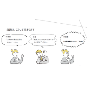
We have released a white paper titled "The Common Points of Attendance Issues Highlighted by the Labor Standards Inspection Office." This document provides a clear explanation of the challenges in attendance management that are likely to be pointed out by the Labor Standards Inspection Office, using specific examples. It addresses operational risks commonly seen in many companies, such as attendance aggregation in Excel, timekeeping management through self-reporting, insufficient management of paid leave, and rounding of overtime hours. Additionally, it introduces points that are often highlighted in inspections by the Labor Standards Inspection Office, such as "objective understanding of working hours," "unpaid overtime," "management of the 36 Agreement limits," and "compliance with the obligation to take 5 days of annual leave." This content can serve as an opportunity for companies that think "there have been no problems so far, so it's fine" to review their operations. Companies considering improving the efficiency of attendance management and strengthening compliance are encouraged to take a look. If you have any additional questions, please feel free to let us know.

Jul 08, 2026

Added to bookmarks

Bookmarks list

Bookmark has been removed

Bookmarks list

You can't add any more bookmarks

By registering as a member, you can increase the number of bookmarks you can save and organize them with labels.

Free membership registration

[Please introduce this to the management and general affairs department] With a checklist for evaluation! The back office system overturns the "single manufacturer option"! Are you aware of the benefits of adopting an agency?

  • NEW
  • CATALOG

What do the members of the back office department consider when choosing or replacing a system? If the same product is handled by both a "manufacturer" and a "distributor," how do you feel about it? "Distributor"? Isn't it cheaper to buy directly from the manufacturer? It's obvious that receiving direct service is better, right? ...Is that really the case? In the materials we are releasing this time, we will explain the benefits of "introducing a distributor." Here’s a preview of the materials: 【If you’re going to choose, you should leverage the power of a distributor that handles the ○○ system!】 【Make the distributor your ○○○○○○○ and use them to the fullest!】 Along with these points, we are offering a "Distributor Evaluation Checklist" that will be your strong ally, free of charge! Please make good use of it.

Jul 07, 2026

Added to bookmarks

Bookmarks list

Bookmark has been removed

Bookmarks list

You can't add any more bookmarks

By registering as a member, you can increase the number of bookmarks you can save and organize them with labels.

Free membership registration

Introducing commercial aroma diffusers to cabaret clubs in Kanagawa Prefecture! The fragrance experience is by Majesta Fragrance.

  • NEW
  • PRODUCT

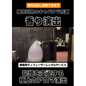
We have introduced the commercial diffuser rental service "MajestaFragrance" to cabaret club establishments in Kanagawa Prefecture. In the nightlife business, such as cabaret clubs, lounges, clubs, and bars, the ambiance created by "fragrance" significantly influences the store's impression and branding, in addition to interior design and lighting. The high-quality scent that customers experience the moment they open the door enhances the sense of luxury and cleanliness, elevating the first impression of the establishment. Creating a memorable space also contributes to increased repeat rates and customer satisfaction. For the establishments that have adopted our service, we selected a sophisticated fragrance inspired by luxury hotels. MajestaFragrance also offers free trial installations. If you are interested in fragrance design, please feel free to contact us.

Jul 06, 2026

Added to bookmarks

Bookmarks list

Bookmark has been removed

Bookmarks list

You can't add any more bookmarks

By registering as a member, you can increase the number of bookmarks you can save and organize them with labels.

Free membership registration

[Special Selection] Commercial Air Conditioners - Benefits of the Latest Commercial Air Conditioners for Store Management - | Suminomori

  • NEW
  • PRODUCT

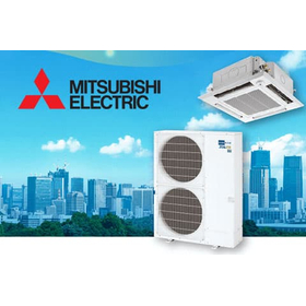
When it comes to updating commercial air conditioning systems, it is often thought of as a way to "reduce electricity costs," but replacing them with the latest models brings various benefits to the operation of stores and offices as well. By improving air conditioning performance, it helps to minimize temperature variations within the store or office, creating a comfortable environment for customers and staff. Additionally, it reduces the risk of sudden breakdowns due to aging equipment, which is a significant advantage in minimizing the impact on business operations. Among these, Mitsubishi Electric's "Mr. SLIM" not only boasts energy-saving performance but also offers a diverse lineup of indoor units, allowing for flexible proposals tailored to the installation environment, whether it be a store, office, or restaurant. Commercial air conditioning is not just a facility that provides heating and cooling; it is an essential system that supports the creation of a comfortable space and the operation of stores. If you are considering an update, please feel free to consult with "Sumino Mori."

Jul 06, 2026

Added to bookmarks

Bookmarks list

Bookmark has been removed

Bookmarks list

You can't add any more bookmarks

By registering as a member, you can increase the number of bookmarks you can save and organize them with labels.

Free membership registration

DXsite NETIS registration information

  • NEW
  • PRODUCT

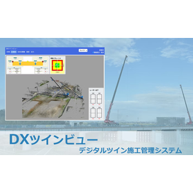
Notice of DXsite NETIS Registration Thank you very much for your continued support of our services. We are pleased to announce that our service, DX Twin View, has been registered as a new technology with NETIS. Technology Name: Digital Twin Construction Management System (DX Twin View) NETIS Registration Number: KK-260017-A We will continue to strive to be a company that meets our customers' expectations with reliable technology and new ideas. We appreciate your continued support.

Jul 06, 2026

Added to bookmarks

Bookmarks list

Bookmark has been removed

Bookmarks list

You can't add any more bookmarks

By registering as a member, you can increase the number of bookmarks you can save and organize them with labels.

Free membership registration
Return to news list
  • Inquiry about this news

    Contact Us Online

Products

  • Search for Products

Company

  • Search for Companies

Special Features

  • Special Features

Ranking

  • Overall Products Ranking
  • Overall Company Ranking

support

  • site map
IPROS
  • privacy policy Regarding external transmission of information
  • terms of service
  • About Us
  • Careers
  • Advertising
COPYRIGHT © 2001-2026 IPROS CORPORATION ALL RIGHTS RESERVED.
Please note that the English text on this page is automatically translated and may contain inaccuracies.